Bruceton Mills, West Virginia

Last updated

Bruceton Mills, West Virginia
Bruceton Mills.jpg
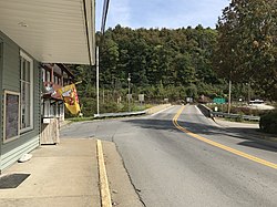
Looking east from Morgantown Street toward North Preston Highway in Bruceton Mills
Preston County West Virginia Incorporated and Unincorporated areas Bruceton Mills Highlighted.svg
Location of Bruceton Mills in Preston County, West Virginia
Coordinates: 39°39′33″N79°38′26″W / 39.65917°N 79.64056°W / 39.65917; -79.64056
Country United States
State West Virginia
County Preston
Area
[1]
  Total0.06 sq mi (0.14 km2)
  Land0.06 sq mi (0.14 km2)
  Water0.00 sq mi (0.00 km2)
Elevation
[2]
1,532 ft (467 m)
Population
 (2020) [3]
  Total64
  Estimate 
(2021) [3]
64
  Density1,527.27/sq mi (584.87/km2)
Time zone UTC-5 (Eastern (EST))
  Summer (DST) UTC-4 (EDT)
ZIP code
26525
Area code 304
FIPS code 54-10852 [4]
GNIS feature ID1553998 [2]

Bruceton Mills is a town in northern Preston County, West Virginia, United States, along Big Sandy Creek. The population was 64 at the 2020 census, making it the second-least populous town in West Virginia, after Thurmond. [3] It is part of the Morgantown metropolitan area.

Contents

History

Old Hemlock southeast of Bruceton Mills Doghouse.JPG
Old Hemlock southeast of Bruceton Mills

An early settler, John M. Hoffman, named this community for his stepfather, George Bruce, who claimed direct descendance from Robert the Bruce, King of Scotland. [5] The post office existed in 1870. Bruceton Mills is the only place in the United States with this name.

Geography

Bruceton Mills is located at 39°39′33″N79°38′26″W / 39.65917°N 79.64056°W / 39.65917; -79.64056 (39.659111, -79.640693). [6]

According to the United States Census Bureau, the town has a total area of 0.06 square miles (0.16 km2), all land. [7]

Climate

The climate in this area has mild differences between highs and lows, and there is adequate rainfall year-round. According to the Köppen Climate Classification system, Bruceton Mills has a marine west coast climate, abbreviated "Cfb" on climate maps. [8]

Demographics

Historical population
CensusPop.Note
1880 84
1900 80
1910 11645.0%
1920 106−8.6%
1930 1169.4%
1940 16542.2%
1950 1650.0%
1960 20926.7%
1970 2090.0%
1980 29641.6%
1990 132−55.4%
2000 74−43.9%
2010 8514.9%
2020 64−24.7%
2021 (est.)64 [3] 0.0%
U.S. Decennial Census [9]

2010 census

As of the census [10] of 2010, there were 85 people, 42 households, and 22 families living in the town. The population density was 1,416.7 inhabitants per square mile (547.0/km2). There were 47 housing units at an average density of 783.3 per square mile (302.4/km2). The racial makeup of the town was 100.0% White.

There were 42 households, of which 28.6% had children under the age of 18 living with them, 40.5% were married couples living together, 11.9% had a female householder with no husband present, and 47.6% were non-families. 45.2% of all households were made up of individuals, and 21.4% had someone living alone who was 65 years of age or older. The average household size was 2.02 and the average family size was 2.73.

The median age in the town was 41.4 years. 17.6% of residents were under the age of 18; 14.1% were between the ages of 18 and 24; 27.1% were from 25 to 44; 17.6% were from 45 to 64; and 23.5% were 65 years of age or older. The gender makeup of the town was 34.1% male and 65.9% female.

2000 census

As of the census [4] of 2000, there were 74 people, 39 households, and 20 families living in the town. The population density was 1,334.0 inhabitants per square mile (476.2/km2). There were 44 housing units at an average density of 793.2 per square mile (283.1/km2). The racial makeup of the town was 100.00% White.

There were 39 households, out of which 15.4% had children under the age of 18 living with them, 46.2% were married couples living together, 5.1% had a female householder with no husband present, and 46.2% were non-families. 43.6% of all households were made up of individuals, and 28.2% had someone living alone who was 65 years of age or older. The average household size was 1.90 and the average family size was 2.62.

In the town, the population was spread out, with 10.8% under the age of 18, 9.5% from 18 to 24, 23.0% from 25 to 44, 36.5% from 45 to 64, and 20.3% who were 65 years of age or older. The median age was 48 years. For every 100 females, there were 80.5 males. For every 100 females age 18 and over, there were 73.7 males.

The median income for a household in the town was $25,625, and the median income for a family was $38,333. Males had a median income of $35,417 versus $21,875 for females. The per capita income for the town was $17,369. There were no families and 6.2% of the population living below the poverty line, including no under eighteens and 22.2% of those over 64.
Related Research Articles

<span class="mw-page-title-main">Belington, West Virginia</span> City in West Virginia

Belington is a town in Barbour County, West Virginia, United States, situated along the Tygart Valley River. The population was 1,804 as of the 2020 census.

<span class="mw-page-title-main">Gassaway, West Virginia</span> Town in West Virginia, United States

Gassaway is a town in Braxton County, West Virginia, United States. The population was 769 at the 2020 census. Gassaway was incorporated in 1905 and named for Henry Gassaway Davis, the Democratic Party's nominee for Vice President of the United States in 1904. The center of population of West Virginia is located approximately 7 miles (11 km) north of Gassaway.

<span class="mw-page-title-main">Bayard, West Virginia</span> Town in West Virginia, United States

Bayard is a town in Grant County, West Virginia, United States. The population was 200 at the 2020 census. Bayard was incorporated in 1893 and named in honor of Thomas F. Bayard, Jr., who later became a United States senator from Delaware (1923–1929). Bayard was founded on the West Virginia Central and Pittsburgh Railroad as a coal mining community. Coal mining has remained the town's chief industry.

<span class="mw-page-title-main">West Milford, West Virginia</span> Town in West Virginia, United States

West Milford is a town in Harrison County, West Virginia, United States. The population was 452 at the 2020 census.

<span class="mw-page-title-main">Jane Lew, West Virginia</span> Town in West Virginia, United States

Jane Lew is a town in Lewis County, West Virginia, United States. The population was 409 at the time of the 2020 census.

<span class="mw-page-title-main">Weston, West Virginia</span> City in West Virginia, United States

Weston is a city in and the county seat of Lewis County, West Virginia, United States. The population was 3,943 at the 2020 census. It is home to the Museum of American Glass in West Virginia and the Trans-Allegheny Lunatic Asylum.

<span class="mw-page-title-main">Man, West Virginia</span> Town in West Virginia, United States

Man is a town in Logan County, West Virginia, United States. The population was 772 at the 2020 census. The town is located along the Guyandotte River at the mouth of Buffalo Creek, which was the site of the 1972 Buffalo Creek Flood following a dam collapse. The name of the town reportedly derives from the last syllable of the surname of Ulysses Hinchman, who was a member of the House of Delegates from Logan County between 1866 and 1869.

<span class="mw-page-title-main">Henderson, West Virginia</span> Unincorporated Town in West Virginia, United States

Henderson is an unincorporated community and former town in Mason County, West Virginia, United States, at the confluence of the Ohio and Kanawha Rivers. The population was 231 at the 2020 census. It is part of the Point Pleasant, WV–OH Micropolitan Statistical Area. The town was incorporated in 1893 and named for Samuel Bruce Henderson, who owned the townsite at the time. The town was unincorporated following a public hearing on August 11, 2022.

<span class="mw-page-title-main">Mason, West Virginia</span> Town in West Virginia, United States

Mason, also known as Mason City, is a town in Mason County, West Virginia, United States. The population was 865 at the 2020 census. It is part of the Point Pleasant, WV–OH Micropolitan Statistical Area.

<span class="mw-page-title-main">Kermit, West Virginia</span> Town in West Virginia, United States

Kermit is a town in Mingo County, West Virginia, United States. The population was 406 at the 2010 census. Kermit is located along the Tug Fork, opposite Warfield, Kentucky. The Norfolk Southern Railway's Kenova District runs through town.

<span class="mw-page-title-main">Granville, West Virginia</span> Town in West Virginia

Granville is a town in Monongalia County, West Virginia, United States. The population was 1,355 at the 2020 census. It is included in the Morgantown metropolitan area.

<span class="mw-page-title-main">Rowlesburg, West Virginia</span> Town in West Virginia, United States

Rowlesburg is a town in southern Preston County, West Virginia, United States, along the Cheat River. The population was 438 at the 2020 census. It is part of the Morgantown metropolitan area. A former railroad town, it is home to the Downtown Rowlesburg Historic District, and was the site of action during the American Civil War.

<span class="mw-page-title-main">Terra Alta, West Virginia</span> Town in West Virginia, United States

Terra Alta is a town in eastern Preston County, West Virginia, United States. The population was 1,415 at the 2020 census. It is part of the Morgantown metropolitan area.

<span class="mw-page-title-main">Mill Creek, West Virginia</span> Town in West Virginia, United States

Mill Creek is a town in Randolph County, West Virginia, United States, along the Tygart Valley River. The population was 563 at the 2020 census.

<span class="mw-page-title-main">Cairo, West Virginia</span> Town in West Virginia, United States

Cairo is a town in Ritchie County, West Virginia, United States, along West Virginia Route 31, the North Fork of the Hughes River, and the North Bend Rail Trail. The population was 174 at the 2020 census.

<span class="mw-page-title-main">Hambleton, West Virginia</span> Town in West Virginia, United States

Hambleton is a town in Tucker County, West Virginia, United States. The population was 216 at the 2020 census. Hambleton was established in 1889, but not incorporated until 1905. It was named by then United States Senator Stephen B. Elkins in honor of a stockholder by this name in the West Virginia Central Railroad Company. The town was previously known as Hulings.

<span class="mw-page-title-main">Middlebourne, West Virginia</span> Town in West Virginia, United States

Middlebourne is a town in Tyler County, West Virginia, United States. The population was 715 at the 2020 census. It serves as the county seat of Tyler County.

<span class="mw-page-title-main">Smithfield, West Virginia</span> Town in West Virginia, United States

Smithfield is a town in Wetzel County, West Virginia, United States. The population was 103 at the 2020 census.

<span class="mw-page-title-main">Elizabeth, West Virginia</span> Town in West Virginia, United States

Elizabeth is a town in and the county seat of Wirt County, West Virginia, United States, situated along the Little Kanawha River. The population was 724 as of the 2020 census.

Lake No. 1 is an unorganized territory in Lake County, Minnesota, United States. The population was 117 at the 2000 census.

References

  1. "2019 U.S. Gazetteer Files". United States Census Bureau. Retrieved August 7, 2020.
  2. 1 2 U.S. Geological Survey Geographic Names Information System: Bruceton Mills, West Virginia
  3. 1 2 3 4 "City and Town Population Totals: 2020-2021". Census.gov. US Census Bureau. Retrieved July 3, 2022.
  4. 1 2 "U.S. Census website". United States Census Bureau . Retrieved January 31, 2008.
  5. Morton, Oren Frederic; Cole, J. R. (1914). A History of Preston County, West Virginia. Journal Publishing Company. p.  245.
  6. "US Gazetteer files: 2010, 2000, and 1990". United States Census Bureau. February 12, 2011. Retrieved April 23, 2011.
  7. "US Gazetteer files 2010". United States Census Bureau. Archived from the original on July 2, 2012. Retrieved January 24, 2013.
  8. Climate Summary for Bruceton Mills, West Virginia
  9. "Census of Population and Housing". Census.gov. Retrieved June 4, 2015.
  10. "U.S. Census website". United States Census Bureau . Retrieved January 24, 2013.