Sandy Township is a township in Saint Louis County, Minnesota, United States. The population was 356 at the 2010 census.

The Big Sandy River is a tributary of the Ohio River, approximately 29 miles (47 km) long, in western West Virginia and northeastern Kentucky in the United States. The river forms part of the boundary between the two states along its entire course. Via the Ohio River, it is part of the Mississippi River watershed.
The Big Sandy River may refer to one of the following rivers in the United States:

The Tug Fork is a tributary of the Big Sandy River, 159 miles (256 km) long, in southwestern West Virginia, southwestern Virginia, and eastern Kentucky in the United States. Via the Big Sandy and Ohio rivers, it is part of the watershed of the Mississippi River.
U.S. Route 340 is a spur route of US 40, and runs from Greenville, Virginia to Frederick, Maryland. In Virginia, it runs north–south, parallel and east of US 11, from US 11 north of Greenville via Waynesboro, Grottoes, Elkton, Luray, Front Royal, and Berryville to the West Virginia state line. A short separate piece crosses northern Loudoun County on its way from West Virginia to Maryland.

The Cacapon River, located in the Appalachian Mountains of West Virginia's Eastern Panhandle region, is an 81.0-mile-long (130.4 km) river known for its fishing, boating, wildlife, and scenery. As part of the Potomac River watershed, it is an American Heritage River.
Evansville is an unincorporated community in Preston County, West Virginia, United States. Evansville lies on the Northwestern Turnpike along Little Sandy Creek.
Britt is an unincorporated area in Saint Louis County, Minnesota, United States.
Sherman is an unincorporated community in northern Jackson County, West Virginia, United States, along the Ohio River. It lies along West Virginia Route 68 north of the city of Ravenswood. Its elevation is 600 feet (183 m).
Big Sandy Creek is a 31.3-mile-long (50.4 km) mountain stream which begins in Fayette County, Pennsylvania, and flows into Preston County, West Virginia, in the United States. The Big Sandy flows through Bruceton Mills and Rockville, West Virginia, before crashing down the mountainside and reaching its confluence with the Cheat River at the abandoned town of Jenkinsburg.
Sandy Huff is an unincorporated community in McDowell County, West Virginia, United States. Sandy Huff is located on the Tug Fork, 2 miles (3.2 km) east-northeast of Iaeger.

Hurricane Sandy was the deadliest, most destructive, and strongest hurricane of the 2012 Atlantic hurricane season. The storm inflicted nearly $70 billion in damage and killed 233 people across eight countries from the Caribbean to Canada. The eighteenth named storm, tenth hurricane, and second major hurricane of the year, Sandy was a Category 3 storm at its peak intensity when it made landfall in Cuba. While it was a Category 2 hurricane off the coast of the Northeastern United States, the storm became the largest Atlantic hurricane on record as measured by diameter, with tropical-storm-force winds spanning 1,150 miles (1,850 km).
Sandy is an unincorporated community in Kanawha County, West Virginia, United States.
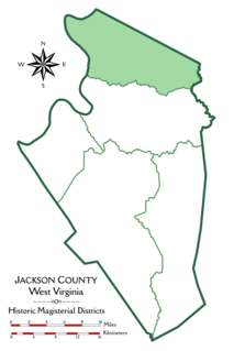
Grant District, formerly Grant Magisterial District, is one of five historic magisterial districts in Jackson County, West Virginia, United States. The district was originally established as a civil township in 1863, and converted into a magisterial district in 1872. When Jackson County was redistricted in the 1990s, the area of Grant District was included in the new Northern Magisterial District. However, the county's historic magisterial districts continue to exist in the form of tax districts, serving all of their former administrative functions except for the election of county officials.

Ravenswood District, formerly Ravenswood Magisterial District, is one of five historic magisterial districts in Jackson County, West Virginia, United States. The district was originally known as Gilmore Township, one of five civil townships established in 1863; the name officially became "Ravenswood" in 1871, and Jackson County's townships were converted into magisterial districts in 1872. When Jackson County was redistricted in the 1990s, the area of Ravenswood District was divided between the new Northern and Western Magisterial Districts. However, the county's historic magisterial districts continue to exist in the form of tax districts, serving all of their former administrative functions except for the election of county officials.
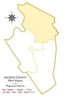
The Northern Magisterial District is one of three magisterial districts in Jackson County, West Virginia, United States. It was established during a process of redistricting undertaken in the 1990s. In 2010, 8,753 people lived in the district.

The Western Magisterial District is one of three magisterial districts in Jackson County, West Virginia, United States. It was established during a process of redistricting undertaken in the 1990s. In 2010, 10,576 people lived in the district.


