
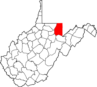
Preston County is a county located in the U.S. state of West Virginia. As of the 2020 Census, the population was 34,216. Its county seat is Kingwood. The county was formed from Monongalia County in 1818 and named for Virginia Governor James Patton Preston.
Preston is a place name, surname and given name that may refer to:

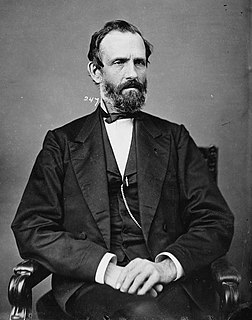
William Ballard Preston was an American politician who served as a Confederate States Senator from Virginia from February 18, 1862, until his death in November. He previously served as the 19th United States Secretary of the Navy from 1849 to 1850. He is also the cousin of William Campbell Preston and William Preston.
The Northwestern Turnpike is a historic road in West Virginia, important for being historically one of the major roads crossing the Appalachians, financed by the Virginia Board of Public Works in the 1830s. In modern times, west of Winchester, Virginia, U.S. Route 50 follows the path of the Northwestern Turnpike into West Virginia, whose major Corridor D project follows the western section of the original Northwestern Turnpike.

This is a list of properties and historic districts in West Virginia that are listed on the National Register of Historic Places. There are listings in every one of West Virginia's 55 counties.
Independence is an unincorporated community in Preston County, West Virginia, United States, adjacent to the town of Newburg.

U.S. Route 50 in West Virginia runs from the border with Ohio to Virginia, passing briefly through Garrett County, Maryland, and following the Northwestern Turnpike. Prior to the U.S. Highway System it was West Virginia Route 1 and in the 1930s, the road was not finished in Maryland. Today the section of US 50 from Clarksburg to Parkersburg on the Ohio River is part of Corridor D of the Appalachian Development Highway System.

William Gay Brown Sr. was a nineteenth-century politician and lawyer from Virginia, who was twice elected to the Virginia General Assembly and thrice to the U.S. House of Representatives. He also served at the Virginia Constitutional Convention of 1850 and later opposed secession at the Virginia Secession Convention of 1861. A leading Unconditional Unionist during the American Civil War, he became one of the founders of West Virginia.
James Clark McGrew was an American politician, merchant, banker and hospital director from Virginia and West Virginia.
This is a list of the National Register of Historic Places listings in Preston County, West Virginia. This is intended to be a complete list of the properties and districts on the National Register of Historic Places in Preston County, West Virginia. The locations of National Register properties and districts for which the latitude and longitude coordinates are included below, may be seen in an online map.
Pleasantdale and Pleasant Dale can refer to:
Cascade is an unincorporated community in Preston County, West Virginia, United States. Cascade is located along West Virginia Route 7, Deckers Creek, and a CSX Railroad line 1.2 miles (1.9 km) northwest of Morgantown.
Rockville is an unincorporated community located in Preston County, West Virginia, United States.
West End is an unincorporated community in Preston County, West Virginia, United States.
Cranesville is an unincorporated community in Preston County, West Virginia, United States. Cranesville is located along County Route 47, 7.9 miles (12.7 km) north-northeast of Terra Alta.
Brookside is an unincorporated community in Preston County, West Virginia, United States. Brookside is located at the junction of U.S. Route 50 and West Virginia Route 24, 7.9 miles (12.7 km) east-southeast of Rowlesburg.
Cheat Canyon Wildlife Management Area is located on 3,836 acres (1,552 ha) northwest of Albright in Preston County, West Virginia. The wildlife management area is centered on the Cheat River canyon.

Fairfax Pond-Rehe Wildlife Management Area is located on 638 acres (258 ha) south of Reedsville in Preston County, West Virginia. The wildlife management area is centered on a series of ponds and wetlands remaining from previous strip mining operations. The land was acquired in 2014.
Herring is an unincorporated community in Preston County, West Virginia, United States.
Pleasantdale is a census-designated place (CDP) in West Orange Township, Essex County, New Jersey, United States. It is in the northwest part of the township, bordered to the north by Eagle Rock Avenue, to the east by Pleasant Valley Way, to the south by Interstate 280, and to the west by Livingston Township and the borough of Roseland. The boundaries of the CDP may differ from local understanding of the community's extent. Crestmont Country Club atop Second Watchung Mountain occupies the western side of the CDP.


