
The Ohio River is a 981-mile (1,579 km) long river in the United States. It is located at the boundary of the Midwestern and Southern United States, flowing in a southwesterly direction from western Pennsylvania to its mouth on the Mississippi River at the southern tip of Illinois. It is the third largest river by discharge volume in the United States and the largest tributary by volume of the north-south flowing Mississippi River that divides the eastern from western United States. It is also the 6th oldest river on the North American continent. The river flows through or along the border of six states, and its drainage basin includes parts of 14 states. Through its largest tributary, the Tennessee River, the basin includes several states of the southeastern U.S. It is the source of drinking water for five million people.

The Appalachian Mountains, often called the Appalachians, are a system of mountains in eastern to northeastern North America. The Appalachians first formed roughly 480 million years ago during the Ordovician Period. They once reached elevations similar to those of the Alps and the Rocky Mountains before experiencing natural erosion. The Appalachian chain is a barrier to east–west travel, as it forms a series of alternating ridgelines and valleys oriented in opposition to most highways and railroads running east–west.

Rockingham County is a county located in the U.S. state of Virginia. As of the 2020 census, the population was 83,757. Its county seat is the independent city of Harrisonburg.

Point Pleasant is a city in and the county seat of Mason County, West Virginia, United States, at the confluence of the Ohio and Kanawha Rivers. The population was 4,101 at the 2020 census. It is the principal city of the Point Pleasant micropolitan area extending into Ohio. The town is best known for the Mothman, a purported humanoid creature reportedly sighted in the area that has become a part of West Virginia folklore.

The Monongahela River, sometimes referred to locally as the Mon, is a 130-mile-long (210 km) river on the Allegheny Plateau in north-central West Virginia and Southwestern Pennsylvania. The river flows from the confluence of its west and east forks in north-central West Virginia northeasterly into southwestern Pennsylvania, then northerly to Pittsburgh and its confluence with the Allegheny River to form the Ohio River. The river includes a series of locks and dams that makes it navigable.

The Great Appalachian Valley, also called The Great Valley or Great Valley Region, is one of the major landform features of eastern North America. It is a gigantic trough—a chain of valley lowlands—and the central feature of the Appalachian Mountains system. The trough stretches about 1,200 miles (1,900 km) from Quebec in the north to Alabama in the south and has been an important north–south route of travel since prehistoric times.

The Allegheny Mountain Range, informally the Alleghenies, is part of the vast Appalachian Mountain Range of the Eastern United States and Canada and posed a significant barrier to land travel in less developed eras. The Allegheny Mountains have a northeast–southwest orientation, running for about 400 miles (640 km) from north-central Pennsylvania, southward through western Maryland and eastern West Virginia.

The Kanawha River is a tributary of the Ohio River, approximately 97 mi (156 km) long, in the U.S. state of West Virginia. The largest inland waterway in West Virginia, its watershed has been a significant industrial region of the state since early in the 19th century.
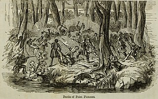
The Battle of Point Pleasant, also known as the Battle of Kanawha and the Battle of Great Kanawha, was the only major action of Dunmore's War. It was fought on October 10, 1774, between the Virginia militia and Shawnee and Mingo warriors. Along the Ohio River near modern-day Point Pleasant, West Virginia, forces under the Shawnee chief Cornstalk attacked Virginia militiamen under Colonel Andrew Lewis, hoping to halt Lewis's advance into the Ohio Valley. After a long and furious battle, Cornstalk retreated. After the battle, the Virginians, along with a second force led by Lord Dunmore, the Royal Governor of Virginia, marched into the Ohio Valley and compelled Cornstalk to agree to a treaty, which ended the war.

The Chesapeake and Ohio Railway was a Class I railroad formed in 1869 in Virginia from several smaller Virginia railroads begun in the 19th century. Led by industrialist Collis P. Huntington, it reached from Virginia's capital city of Richmond to the Ohio River by 1873, where the railroad town of Huntington, West Virginia, was named for him.

Shenandoah Mountain is a mountain ridge approximately 73 miles (117 km) long in Virginia and West Virginia. The steep, narrow, sandstone-capped ridge extends from northern Bath County, Virginia to southern Hardy County, West Virginia. Along the way, its crest defines the borders between Highland and Augusta counties, Virginia, and between Pendleton County, West Virginia, and Rockingham County, Virginia. The name comes from the Iroquoian word for 'deer'. Its high point is 4397’/1340 m Reddish Knob along the Virginia/West Virginia border.

Cass Scenic Railroad State Park is a state park and heritage railroad located in Cass, Pocahontas County, West Virginia.

Roneys Point is an unincorporated community in Ohio County, West Virginia, United States. Roneys Point is located along Little Wheeling Creek on the National Road between Point Mills and Valley Camp. It is part of the Wheeling, West Virginia Metropolitan Statistical Area.

U.S. Route 50 is a transcontinental highway which stretches from Ocean City, Maryland to West Sacramento, California. In the U.S. state of Virginia, US 50 extends 86 miles (138 km) from the border with Washington, D.C. at a Potomac River crossing at Rosslyn in Arlington County to the West Virginia state line near Gore in Frederick County.

Canaan Valley Resort State Park is a state park in the eastern United States, within Canaan Valley in Tucker County, West Virginia. Located in the highest valley east of the Mississippi River, the park contains the second-largest inland wetland area in the United States. The valley featured the first commercial ski development in West Virginia.

Jefferson Rock is a rock formation on the Appalachian Trail in Harpers Ferry, West Virginia. It consists of several large masses of Harpers shale, piled one upon the other, that overlook the Shenandoah River just prior to its confluence with the Potomac River. It was added to the National Register of Historic Places as a contributing property of the Harpers Ferry National Historical Park on October 15, 1966.
Valley Head is a census-designated place (CDP) in Randolph County, West Virginia, United States. Valley Head is located on U.S. Route 219, 12 miles (19 km) south-southwest of Huttonsville. Valley Head has a post office with ZIP code 26294. As of the 2010 census, its population was 267.
Verdunville is an unincorporated community and census-designated place (CDP) in Logan County, West Virginia, United States. It is 3.5 miles (5.6 km) west of Logan, the county seat. Verdunville has a post office with ZIP code 25649. The Verdunville CDP includes the neighboring community of Shegon. As of the 2010 census, the total CDP population was 687.
Parchment Valley is an unincorporated community in Jackson County, West Virginia, United States. Parchment Valley is located at the junction of County Routes 15 and 30, 3.5 miles (5.6 km) south-southwest of Ripley. Parchment Valley once had a post office, which is now closed.
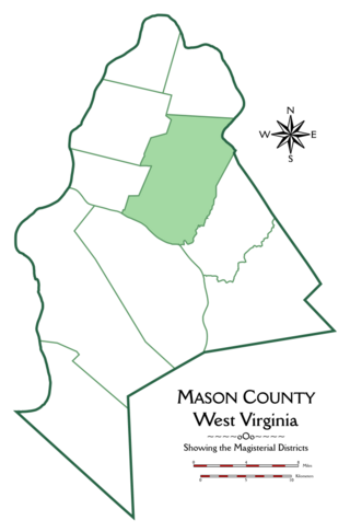
Cooper Magisterial District is one of ten magisterial districts in Mason County, West Virginia, United States. The district was originally established as a civil township in 1863, and converted into a magisterial district in 1872. In 2020, Cooper District was home to 1,700 people.


