Flatwoods, West Virginia

Last updated

Flatwoods, West Virginia
Flatwoods West Virginia.jpg
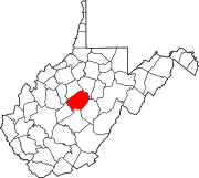
Braxton County West Virginia Incorporated and Unincorporated areas Flatwoods Highlighted.svg
Location of Flatwoods in Braxton County, West Virginia.
Coordinates: 38°43′17″N80°39′11″W / 38.72139°N 80.65306°W / 38.72139; -80.65306
Country Flag of the United States.svg  United States
State Flag of West Virginia.svg  West Virginia
County Braxton
Incorporated 1901;123 years ago (1901)
Government
[1]
  Type Mayor-Council
  MayorDale A. Ball
  Chief of PoliceShawn Brown
Area
[2]
  Total0.66 sq mi (1.70 km2)
  Land0.66 sq mi (1.70 km2)
  Water0.00 sq mi (0.00 km2)
Elevation
[1]
1,071 ft (326 m)
Population
 (2020) [3]
  Total264
  Density400/sq mi (160/km2)
Time zone UTC-5 (Eastern (EST))
  Summer (DST) UTC-4 (EDT)
ZIP code
26621
Area code 304
FIPS code 54-27868 [4]
GNIS feature ID1539070 [5]
Website https://flatwoodswv.org/

Flatwoods is a town in Braxton County, West Virginia, United States, located approximately one mile from exit 67 of Interstate 79.

Contents

The population of Flatwoods was 264 as of the 2020 census.

History

Although first incorporated in 1902, maps show the existence of Flatwoods as a town in 1873, [6] and a church was established by a pastor named John Clark at the community there as early as 1830. [7] The West Virginia and Pittsburgh Railroad extended a branch through Flatwoods in the late 1800s. [8] Later, the line was taken over by Baltimore and Ohio Railroad, and Flatwoods was a halfway point on the B&O Railroad's Clarksburg-Richwood branch, approximately 62.6 miles from the Clarksburg terminal, and 59.1 miles from the Richwood terminal. [9] The town also served as the origin of West Virginia & Pittsburgh Railroad's Sutton Branch. [8]

Flatwoods monster chair, on the lawn by the town hall, welcomes visitors. Flatwoods Visitor Chair.jpg
Flatwoods monster chair, on the lawn by the town hall, welcomes visitors.

The community became nationally known for the Flatwoods monster UFO incident which occurred on September 12, 1952.

Geography

Flatwoods is located at 38°43′17″N80°39′11″W / 38.721374°N 80.652957°W / 38.721374; -80.652957 (38.721374, -80.652957). [10] According to the United States Census Bureau, the town has a total area of 0.66 square miles (1.71 km2), all land. [11]

Demographics

Historical population
CensusPop.Note
1910 284
1920 32514.4%
1930 299−8.0%
1940 3083.0%
1950 288−6.5%
1960 248−13.9%
1970 220−11.3%
1980 40584.1%
1990 324−20.0%
2000 3487.4%
2010 277−20.4%
2020 264−4.7%
U.S. Decennial Census [12]

2010 census

At the 2010 census there were 277 people, 109 households, and 74 families living in the town. The population density was 419.7 inhabitants per square mile (162.0/km2). There were 127 housing units at an average density of 192.4 per square mile (74.3/km2). The racial makeup of the town was 99.3% White, 0.4% Asian, and 0.4% from two or more races. Hispanic or Latino of any race were 0.7%. [3]

Of the 109 households 33.0% had children under the age of 18 living with them, 50.5% were married couples living together, 13.8% had a female householder with no husband present, 3.7% had a male householder with no wife present, and 32.1% were non-families. 28.4% of households were one person and 11% were one person aged 65 or older. The average household size was 2.54 and the average family size was 3.12.

The median age in the town was 41.2 years. 27.1% of residents were under the age of 18; 6.9% were between the ages of 18 and 24; 22.8% were from 25 to 44; 28.2% were from 45 to 64; and 15.2% were 65 or older. The gender makeup of the town was 48.4% male and 51.6% female.

2000 census

At the 2000 census there were 348 people, 146 households, and 102 families living in the town. The population density was 328.7 inhabitants per square mile (126.8/km2). There were 157 housing units at an average density of 148.3 per square mile (57.2/km2). The racial makeup of the town was 97.13% White, 0.57% Asian, 0.29% Pacific Islander, and 2.01% from two or more races. [4] Of the 146 households 29.5% had children under the age of 18 living with them, 58.2% were married couples living together, 8.9% had a female householder with no husband present, and 29.5% were non-families. 26.0% of households were one person and 13.0% were one person aged 65 or older. The average household size was 2.38 and the average family size was 2.89.

The age distribution was 24.1% under the age of 18, 5.2% from 18 to 24, 29.6% from 25 to 44, 27.9% from 45 to 64, and 13.2% 65 or older. The median age was 39 years. For every 100 females, there were 94.4 males. For every 100 females age 18 and over, there were 88.6 males. The median household income was $29,500 and the median family income was $35,250. Males had a median income of $30,000 versus $15,938 for females. The per capita income for the town was $18,025. About 11.4% of families and 18.0% of the population were below the poverty line, including 20.2% of those under age 18 and 8.6% of those age 65 or over.

Flatwoods appears in the video game Fallout 76 , set in West Virginia. It is the first main town the players encounter during their quest.

Related Research Articles

<span class="mw-page-title-main">Braxton County, West Virginia</span> County in West Virginia, United States

Braxton County is a county in the central part of the U.S. state of West Virginia. As of the 2020 census, the population was 12,447. The county seat is Sutton. The county was formed in 1836 from parts of Lewis, Kanawha, and Nicholas counties and named for Carter Braxton, a Virginia statesman and signer of the Declaration of Independence.

<span class="mw-page-title-main">Nicholas County, West Virginia</span> County in West Virginia, United States

Nicholas County is a county located in the central region of U.S. state of West Virginia. As of the 2020 census, the population was 24,604. Its county seat is Summersville. The county was created in 1818 by the Virginia General Assembly and named for Virginia Governor Wilson Cary Nicholas.

<span class="mw-page-title-main">Russell, Kentucky</span> City in Kentucky, United States

Russell is a home rule-class city on the south bank of the Ohio River in Greenup County, Kentucky, United States. The population was 3,380 as of the 2010 census, down from 3,645 in 2000. Russell is a suburb of Ashland and part of the Huntington-Ashland-Ironton metropolitan area. It has close economic affiliations with its neighbors, Ashland and Flatwoods in Kentucky and Ironton, Ohio.

<span class="mw-page-title-main">Burnsville, West Virginia</span> Town in West Virginia, United States

Burnsville is a town in Braxton County, West Virginia, United States, at the confluence of the Little Kanawha River and Saltlick Creek. The population was 401 at the 2020 census. Burnsville was incorporated in 1902 by the Circuit Court and named for Captain John Burns who operated the first sawmill in that section of the state and who established the town shortly after the close of the American Civil War. It was named "All West Virginia City" in 1976.

<span class="mw-page-title-main">Sutton, West Virginia</span> Town in West Virginia

Sutton is a town in Braxton County, West Virginia, United States. The population was 876 at the 2020 census. It is the county seat of Braxton County. Sutton is situated at a center of transportation in West Virginia. Interstate 79, a major north–south route, connects with Appalachian Corridor L, another significant north–south route, passes several miles south of town.

<span class="mw-page-title-main">Bayard, West Virginia</span> Town in West Virginia, United States

Bayard is a town in Grant County, West Virginia, United States. The population was 200 at the 2020 census. Bayard was incorporated in 1893 and named in honor of Thomas F. Bayard, Jr., who later became a United States senator from Delaware (1923–1929). Bayard was founded on the West Virginia Central and Pittsburgh Railroad as a coal mining community. Coal mining has remained the town's chief industry.

<span class="mw-page-title-main">West Logan, West Virginia</span> Town in West Virginia, United States

West Logan is a town along the Guyandotte River in Logan County, West Virginia, United States. The population was 400 at the 2020 census. For unknown reasons, some sources report West Logan to lay west of the county seat at Logan, attributing to this fact the name.

<span class="mw-page-title-main">Worthington, West Virginia</span> Town in West Virginia, United States

Worthington is a town in Marion County, West Virginia, United States. The population was 158 at the 2010 census. Worthington was incorporated in 1893 and named for Colonel George Worthington, an early settler. U.S. Route 19 passes through the town.

<span class="mw-page-title-main">Gilbert, West Virginia</span> Town in West Virginia, United States

Gilbert is a town in Mingo County, West Virginia, United States, along the Guyandotte River. The population was 333 at the 2020 census. Gilbert was incorporated in 1918 and named for Gilbert Creek, which derives its name from the name of an early traveler in the area who was killed by Native Americans. Gilbert is known nationwide for the Hatfield-McCoy ATV Trails that are located in the area. There are a number of lodges and restaurants in Gilbert.

<span class="mw-page-title-main">Richwood, West Virginia</span> City in West Virginia, United States

Richwood is a city in Nicholas County, West Virginia, United States. In 2020, the census showed Richwood with a population of 1,661. During the 19th and early 20th century Richwood was a booming coal and lumber town. Richwood has a very rich history, including the formation of the Cherry River Navy civic organization to draw attention to issues important to the community. Richwood has also become known statewide as the "Ramp Capital of the World". Each year, in April, the city hosts a large festival that draws visitors from around the country.

<span class="mw-page-title-main">Belmont, West Virginia</span> Town in West Virginia, United States

Belmont is a town in Pleasants County, West Virginia, United States. It is part of the Parkersburg–Vienna metropolitan area. The population was 872 at the 2020 census. Belmont was incorporated on April 19, 1946 by the Circuit Court of Pleasants County. The city was named for the beautiful hills in the area.

<span class="mw-page-title-main">Durbin, West Virginia</span> Town in West Virginia, United States

Durbin is a town in Pocahontas County, West Virginia, United States. The population was 235 at the 2020 census.

<span class="mw-page-title-main">Rowlesburg, West Virginia</span> Town in West Virginia, United States

Rowlesburg is a town in southern Preston County, West Virginia, United States, along the Cheat River. The population was 438 at the 2020 census. It is part of the Morgantown metropolitan area. A former railroad town, it is home to the Downtown Rowlesburg Historic District, and was the site of action during the American Civil War.

<span class="mw-page-title-main">Terra Alta, West Virginia</span> Town in West Virginia, United States

Terra Alta is a town in eastern Preston County, West Virginia, United States. The population was 1,415 at the 2020 census. It is part of the Morgantown metropolitan area.

<span class="mw-page-title-main">Tunnelton, West Virginia</span> Town in West Virginia, United States

Tunnelton is a town in southwestern Preston County, West Virginia, United States. The population was 307 at the 2020 census. It is part of the Morgantown metropolitan area.

<span class="mw-page-title-main">Beverly, West Virginia</span> Town in West Virginia, United States

Beverly is a town in Randolph County, West Virginia, United States. Founded in 1787, it is the oldest settlement in the Tygart River Valley. It had a population of 628 at the 2020 census. Beverly was the county seat of Randolph County for over a century—from 1790 until 1899—after which the nearby settlement of Elkins assumed that role following an intense local political "war".

<span class="mw-page-title-main">Ellenboro, West Virginia</span> Town in West Virginia, United States

Ellenboro is a town in Ritchie County, West Virginia, United States. The population was 222 at the 2020 census. The town is located at the junction of U.S. Route 50 and West Virginia Route 16; the North Bend Rail Trail also passes through the town. The town was named for Ellen Mariah Williamson, the eldest daughter of the family that granted a right of way for the Baltimore and Ohio Railroad to build their line through the town; an earlier name for the community was Shumley. Ellenboro was incorporated in 1903.

<span class="mw-page-title-main">Fort Gay, West Virginia</span> Town in West Virginia, United States

Fort Gay is a town in Wayne County, West Virginia, United States, situated along the Tug Fork and Big Sandy rivers. The town adjoins Louisa, Kentucky. The population was 677 at the 2020 census.

<span class="mw-page-title-main">Cowen, West Virginia</span> Town in West Virginia, United States

Cowen is a town in Webster County, West Virginia, United States. The population was 488 at the 2020 census.

<span class="mw-page-title-main">Montgomery, West Virginia</span> City in West Virginia

Montgomery is a city in West Virginia, along the Kanawha River. Most of the city is in Fayette County, with the remainder in Kanawha County. The population was 1,280 at the 2020 census.

References

  1. 1 2 "About Us". The Town of Flatwoods. Retrieved August 27, 2015.
  2. "2019 U.S. Gazetteer Files". United States Census Bureau. Retrieved August 7, 2020.
  3. 1 2 "U.S. Census website". United States Census Bureau . Retrieved January 24, 2013.
  4. 1 2 "U.S. Census website". United States Census Bureau . Retrieved January 31, 2008.
  5. "US Board on Geographic Names". United States Geological Survey. October 25, 2007. Retrieved January 31, 2008.
  6. "White's Toopographical, County, and District Atlas of West Virginia, Counties of Calhoun, Gilmer, Braxton, Lewis and Upshur (with Weston) 1873". David Rumsey Map Collection. Cartography Associates. Retrieved July 31, 2013.
  7. Sutton, John (1919). History of Braxton County and Central West Virginia. Parsons: McClain Printing Company. p. 234. ISBN   978-0870126215.
  8. 1 2 "West Virginia and Pittsburgh Railroad". wvrailroads.net. wvrailroads.net. Archived from the original on February 8, 2017. Retrieved July 31, 2013.
  9. Fergusson, Jim. "West Virginia Railway Station Lists" (PDF). Jim Fergusson's Railway and Tramway Station Lists. Jim Fergusson. Retrieved July 31, 2013.
  10. "US Gazetteer files: 2010, 2000, and 1990". United States Census Bureau. February 12, 2011. Retrieved April 23, 2011.
  11. "US Gazetteer files 2010". United States Census Bureau. Archived from the original on January 12, 2012. Retrieved January 24, 2013.
  12. "Census of Population and Housing". Census.gov. Retrieved June 4, 2015.