Mannington, West Virginia

Last updated

Mannington, West Virginia
Mannington Historic District Southside Bridge.jpg
Marion County West Virginia Incorporated and Unincorporated areas Mannington Highlighted.svg
Location of Mannington in Marion County, West Virginia.
Coordinates: 39°31′38″N80°20′23″W / 39.52722°N 80.33972°W / 39.52722; -80.33972
Country United States
State West Virginia
County Marion
Area
[1]
  Total1.14 sq mi (2.95 km2)
  Land1.09 sq mi (2.83 km2)
  Water0.05 sq mi (0.12 km2)
Elevation
974 ft (297 m)
Population
 (2020) [2]
  Total1,961
  Estimate 
(2021) [2]
1,946
  Density1,850.87/sq mi (714.74/km2)
Time zone UTC-5 (Eastern (EST))
  Summer (DST) UTC-4 (EDT)
ZIP code
26582
Area code 304/681
FIPS code 54-51100 [3]
GNIS feature ID1542721 [4]
Website www.cityofmannington.com OOjs UI icon edit-ltr-progressive.svg

Mannington is a city in Marion County, West Virginia, United States, located in the hills of North Central West Virginia. The population was 1,961 at the 2020 census. In its earliest years it was called Forks of Buffalo or Koon Town, but has been called Mannington since 1856.

Contents

History

Early history

At the time of the first settlement, the west fork of Buffalo Creek was known as Warrior's Fork, while the North Fork has historically borne the name of Pyle's Fork. One of the first settlers in the area was John Ice, who was born in the valley of the South Branch of the Potomac River in what was then Virginia. As a child, Ice and his father searched in vain for his mother, two sisters and brother who had been captured by Native Americans. The mother was never found, although the children ultimately were. Only John's brother, known from then on as "Indian Billy" returned to the family. The sisters chose to remain with their one time captors (Prichard 1983).

Native American activity was not uncommon in the area and many settlers and travelers met their fate at the hands of the Native Americans, including John Madison, the cousin of James Madison the future president, who was killed on a surveying trip in the area in 1783. Although not necessarily as a result of this, James Madison did procure, as an investment, some land on Brush Run and Pyles Fork just north of Forks of Buffalo.

The earliest population concentration did not occur in what is now Mannington, but rather approximately two miles west of Dent's Run. Most of the land now falling within the city limits, some 1,360 acres (5.5 km2), was owned by Robert Rutherford, a Revolutionary War financier and an intimate friend of George Washington. In 1799, Rutherford sold his Forks of Buffalo holdings to James Brown of Berkeley County, Virginia, who, after experiencing financial setbacks, eventually sold the property at public sale in 1824 to a group of Baltimore, Maryland, investors which included William Baker. Baker apparently bought out his partners and, in turn, sold the parcel to James Hanway, a surveyor living in Monongalia County, who parceled the land and began selling it. This final transaction occurred in 1840 and it was then that the area now known as Mannington had its genesis.

After the parceling of the land around the Forks of Buffalo, interest in the area increased as did the population. A number of log houses began to be built, with the accompanying entrepreneurial activities that one might expect in an early settlement. By 1850 a tavern owned by George and Samuel Koon appeared in the heart of the burgeoning town. Not long after the tavern was opened, the Forks of Buffalo began to be known as Koon Town. While the local inhabitants may have used the newer name, the United States government failed to do so, in 1850 naming their first postal office in the community the Forks of Buffalo Post Office. It was not until 1856 that the village officially became known as Mannington, named after Charles Manning, a civil engineer with the Baltimore and Ohio (B&O) Railroad. Manning was well liked by the community and the inhabitants were eager to have a more "dignified" name for a growing town on the new railroad line.

The coming of the railroad heralded the introduction of heavier industry in the Mannington area. Logging and coal were two of the obvious industries which were developed along the railroad line, but there were a great many peripheral industries which appeared as well. Tree bark was used by the tanneries, which, in turn, produced a wide range of leather goods. New planing mills, sawmills, and woodworking plants were started, and the availability of transportation also witnessed an increase in cattle, sheep and crop production.

During the American Civil War, the B&O railroad, of vital interest to both of the conflicting sides, sustained more damage than Mannington proper did. While Confederate forces succeeded in burning several of the railroad bridges at the very beginning of the conflict, reinforcements from the Union insured the integrity of the Mannington section of the line for the remainder of the war.

Oil and gas boom

A new chapter in Mannington's history began in 1889 with the first oil drilling, following recommendations made by Dr. Israel C. White, a well-known geologist who later became West Virginia State Geologist. Although many felt that the area was unfavorable for oil reserves, White persisted and soon gained enough local support to drill. Following the first strike, late in 1889, real estate prices soared 100% in two days in a boom-town mentality. The Mannington field became one of the largest in the state, with the largest well producing about 1,600 barrels per day (250 m3/d).

Dr. White also pushed for natural gas exploration. It was this venture, more successful than any before or since, that was most responsible for Mannington's growth. The population increased from approximately 700 people in the late 19th century to over 4,000 by 1917. By 1900, Mannington was a thriving town, complete with its own trolley system, electricity, theaters, schools, fire department, telephones and other amenities. The Mannington School Building, constructed in 1902–1903, was the pride of both the town and the state. In 1923, Albert Heck began the formation of the first community radio cable system from Mannington to its outlying areas.

Boom to bust

The 1929 stock market crash and the Depression severely affected Mannington's economy. The trolley ceased operation in 1933, factory workers left as demand for products decreased, and the town's population began to decline.

Geography

Mannington is located at 39°31′38″N80°20′23″W / 39.52722°N 80.33972°W / 39.52722; -80.33972 (39.527340, -80.339742), [5] along Buffalo Creek. [6]

According to the United States Census Bureau, the city has a total area of 1.15 square miles (2.98 km2), of which 1.10 square miles (2.85 km2) is land and 0.05 square miles (0.13 km2) is water. [7]

Climate

The climate in this area is characterized by relatively high temperatures and evenly distributed precipitation throughout the year. According to the Köppen Climate Classification system, Mannington has a Humid subtropical climate, abbreviated "Cfa" on climate maps. [8]

Climate data for Mannington, West Virginia (1991–2020 normals, extremes 1980–present)
MonthJanFebMarAprMayJunJulAugSepOctNovDecYear
Record high °F (°C)75
(24)
80
(27)
88
(31)
93
(34)
94
(34)
97
(36)
103
(39)
100
(38)
98
(37)
93
(34)
82
(28)
75
(24)
103
(39)
Mean daily maximum °F (°C)38.3
(3.5)
42.1
(5.6)
52.4
(11.3)
65.7
(18.7)
74.1
(23.4)
80.9
(27.2)
84.1
(28.9)
83.1
(28.4)
77.1
(25.1)
65.7
(18.7)
52.8
(11.6)
42.5
(5.8)
63.2
(17.3)
Daily mean °F (°C)28.5
(−1.9)
31.2
(−0.4)
39.7
(4.3)
51.0
(10.6)
60.4
(15.8)
68.1
(20.1)
72.1
(22.3)
70.7
(21.5)
63.8
(17.7)
52.2
(11.2)
41.1
(5.1)
33.2
(0.7)
51.0
(10.6)
Mean daily minimum °F (°C)18.7
(−7.4)
20.3
(−6.5)
27.1
(−2.7)
36.2
(2.3)
46.7
(8.2)
53.3
(11.8)
60.0
(15.6)
58.3
(14.6)
50.5
(10.3)
38.7
(3.7)
29.4
(−1.4)
23.9
(−4.5)
38.8
(3.8)
Record low °F (°C)−34
(−37)
−21
(−29)
−13
(−25)
12
(−11)
25
(−4)
25
(−4)
32
(0)
34
(1)
22
(−6)
14
(−10)
4
(−16)
−24
(−31)
−34
(−37)
Average precipitation inches (mm)4.41
(112)
3.99
(101)
4.36
(111)
4.32
(110)
4.92
(125)
4.44
(113)
5.64
(143)
4.10
(104)
4.17
(106)
3.37
(86)
3.57
(91)
4.15
(105)
51.44
(1,307)
Average precipitation days (≥ 0.01 in)18.215.914.115.415.113.112.610.910.510.712.716.7165.9
Source: NOAA [9] [10]

Demographics

Historical population
CensusPop.Note
1860 241
1870 41170.5%
1890 908
1900 1,68185.1%
1910 2,67259.0%
1920 3,67337.5%
1930 3,261−11.2%
1940 3,145−3.6%
1950 3,2413.1%
1960 2,996−7.6%
1970 2,747−8.3%
1980 3,03610.5%
1990 2,184−28.1%
2000 2,124−2.7%
2010 2,063−2.9%
2020 1,961−4.9%
2021 (est.)1,946 [2] −0.8%
U.S. Decennial Census [11]

2010 census

As of the census [12] of 2010, there were 2,063 people, 842 households, and 578 families living in the city. The population density was 1,875.5 inhabitants per square mile (724.1/km2). There were 964 housing units at an average density of 876.4 per square mile (338.4/km2). The racial makeup of the city was 98.8% White, 0.2% African American, 0.2% Native American, 0.3% Asian, and 0.4% from two or more races. Hispanic or Latino of any race were 0.9% of the population.

There were 842 households, of which 31.8% had children under the age of 18 living with them, 49.5% were married couples living together, 13.3% had a female householder with no husband present, 5.8% had a male householder with no wife present, and 31.4% were non-families. 27.0% of all households were made up of individuals, and 13% had someone living alone who was 65 years of age or older. The average household size was 2.45 and the average family size was 2.95.

The median age in the city was 41.8 years. 23.5% of residents were under the age of 18; 6.8% were between the ages of 18 and 24; 24.6% were from 25 to 44; 27.5% were from 45 to 64; and 17.5% were 65 years of age or older. The gender makeup of the city was 47.8% male and 52.2% female.

2000 census

As of the census [3] of 2000, there were 2,124 people, 884 households, and 625 families living in the city. The population density was 1,823.8 people per square mile (707.0/km2). There were 990 housing units at an average density of 850.1 per square mile (329.5/km2). The racial makeup of the city was 83.9% White,2.54% African American, 0.42% Native American, 0.19% Asian, and 0.71% from two or more races. Hispanics or Latinos of any race were 0.33% of the population.

There were 884 households, out of which 28.3% had children under the age of 18 living with them, 52.7% were married couples living together, 14.4% had a female householder with no husband present, and 29.2% were non-families. 26.4% of all households were made up of individuals, and 17.4% had someone living alone who was 65 years of age or older. The average household size was 2.40 and the average family size was 2.88.

The age distribution was 23.0% under the age of 18, 7.8% from 18 to 24, 25.3% from 25 to 44, 24.7% from 45 to 64, and 19.2% who were 65 years of age or older. The median age was 40 years. For every 100 females, there were 85.2 males. For every 100 females age 18 and over, there were 82.9 males.

The median income for a household in the city was $26,806, and the median income for a family was $31,852. Males had a median income of $25,078 versus $19,464 for females. The per capita income for the city was $13,036. About 12.7% of families and 18.3% of the population were below the poverty line, including 37.1% of those under age 18 and 9.8% of those age 65 or over.

Infrastructure

Roads

Mannington is the model for the fictional town of Grantville in Eric Flint's best selling 1632 series of alternate history novels: 1632 , 1633 , Ring of Fire , The Grantville Gazette , and other book-length and shorter works. [13] The 1632 series has evolved into a large-scale experiment in collaborative fiction and has attracted considerable interest from other best selling writers, including David Weber and Mercedes Lackey. [14] [15] The premise of the series is that, in about April 2000, irresponsible aliens (accidentally) exchanged a sphere with a radius of about three miles (5 km) centered on Grantville with an equally sized chunk of Thuringia from 1631, plunging the town into the midst of the Thirty Years' War. [16]

Mannington continues to be used as a detailed model for the series in order to determine realistically what resources and skill sets the town of Grantville would bring to the past. [17] Flint has stated, "The town of Grantville is very closely modeled on the actual town of Mannington. There are rules that I require everyone to follow when they write in the series. One of them is that it if it wasn’t in the town of Mannington in 2000, you can’t have it in Grantville. The one cheat I had to do was that I needed a power plant. The power plant is about 15 miles away, in a town called Granttown, so I just sorta moved it over. That’s the only real cheat.” [18] The fans and writers of the 1632 series have held at least four conventions in Mannington. The fourth was held on August 46, 2006. [19]

See also

Related Research Articles

<span class="mw-page-title-main">Marion County, West Virginia</span> County in West Virginia, United States

Marion County is a county in the U.S. state of West Virginia. As of the 2020 census, the population was 56,205. Its county seat is Fairmont. The county was named in honor of General Francis Marion, known to history as "The Swamp Fox".

<span class="mw-page-title-main">Cumberland, Kentucky</span> City in Kentucky, United States

Cumberland is a home rule-class city in Harlan County, Kentucky, in the United States. The population according to the 2010 Census was 2,237, down from 2,611 at the 2000 census. The city sits at the confluence of Looney Creek and the Poor Fork Cumberland River.

<span class="mw-page-title-main">Louisa, Kentucky</span> City in Kentucky, United States

Louisa is a home-rule class city located in eastern Kentucky at the merger of the Levisa and Tug Forks into the Big Sandy River, which forms part of the state's border with West Virginia. It is the seat of Lawrence County. The population was 2,467 at the 2010 census and an estimated 2,375 in 2018.

<span class="mw-page-title-main">Clinchco, Virginia</span> Town in Virginia, United States

Clinchco is a town in Dickenson County, Virginia, United States. The town, formerly known as Moss, was named for both the Clinchfield Railroad and the Clinchfield Coal Corporation. The population was 337 at the 2010 census, down from 424 at the 2000 census. The Clinchco post office was established in 1917.

<span class="mw-page-title-main">Haysi, Virginia</span> Town in Virginia, United States

Haysi is a town in Dickenson County, Virginia, United States. The population was 498 at the 2010 census, up from 186 at the 2000 census, over which time period the town's area tripled.
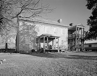
<span class="mw-page-title-main">Falling Spring, West Virginia</span> Town in West Virginia, United States

Falling Spring is a town in Greenbrier County, West Virginia, United States. It is also known as Renick from the name of its post office. The population was 171 at the 2020 census.

<span class="mw-page-title-main">Man, West Virginia</span> Town in West Virginia, United States

Man is a town in Logan County, West Virginia, United States. The population was 772 at the 2020 census. The town is located along the Guyandotte River at the mouth of Buffalo Creek, which was the site of the 1972 Buffalo Creek Flood following a dam collapse. The name of the town reportedly derives from the last syllable of the surname of Ulysses Hinchman, who was a member of the House of Delegates from Logan County between 1866 and 1869.

<span class="mw-page-title-main">Kermit, West Virginia</span> Town in West Virginia, United States

Kermit is a town in Mingo County, West Virginia, United States. The population was 406 at the 2010 census. Kermit is located along the Tug Fork, opposite Warfield, Kentucky. The Norfolk Southern Railway's Kenova District runs through town.

<span class="mw-page-title-main">Williamson, West Virginia</span> City in West Virginia, United States

Williamson is a city in Mingo County, West Virginia, United States, situated along the Tug Fork River. The population was 3,042 at the 2020 census. It is the county seat of Mingo County, and is the county's largest and most populous city. Williamson is home to Southern West Virginia Community and Technical College. The Tug Fork River separates Williamson from South Williamson, Kentucky.

<span class="mw-page-title-main">Durbin, West Virginia</span> Town in West Virginia, United States

Durbin is a town in Pocahontas County, West Virginia, United States. The population was 235 at the 2020 census.

<span class="mw-page-title-main">Rowlesburg, West Virginia</span> Town in West Virginia, United States

Rowlesburg is a town in southern Preston County, West Virginia, United States, along the Cheat River. The population was 438 at the 2020 census. It is part of the Morgantown metropolitan area. A former railroad town, it is home to the Downtown Rowlesburg Historic District, and was the site of action during the American Civil War.

<span class="mw-page-title-main">Terra Alta, West Virginia</span> Town in West Virginia, United States

Terra Alta is a town in eastern Preston County, West Virginia, United States. The population was 1,415 at the 2020 census. It is part of the Morgantown metropolitan area.

<span class="mw-page-title-main">Cairo, West Virginia</span> Town in West Virginia, United States

Cairo is a town in Ritchie County, West Virginia, United States, along West Virginia Route 31, the North Fork of the Hughes River, and the North Bend Rail Trail. The population was 174 at the 2020 census.

<span class="mw-page-title-main">Hambleton, West Virginia</span> Town in West Virginia, United States

Hambleton is a town in Tucker County, West Virginia, United States. The population was 216 at the 2020 census. Hambleton was established in 1889, but not incorporated until 1905. It was named by then United States Senator Stephen B. Elkins in honor of a stockholder by this name in the West Virginia Central Railroad Company. The town was previously known as Hulings.

<span class="mw-page-title-main">Parsons, West Virginia</span> City in West Virginia, United States

Parsons is the largest city in and county seat of Tucker County, West Virginia, United States. The population was 1,322 at the 2020 census. Parsons is located at the confluence of the Shavers Fork and the Black Fork, forming the head of the Cheat River.

<span class="mw-page-title-main">Thomas, West Virginia</span> City in West Virginia, United States

Thomas is a city and former coal town in Tucker County, West Virginia, United States. The population was 623 at the 2020 census.

<span class="mw-page-title-main">Wayne, West Virginia</span> Town in West Virginia, United States

Wayne is a town in and the county seat of Wayne County, West Virginia, United States. The population was 1,441 at the 2020 census. It is part of the Huntington–Ashland metropolitan area.

<span class="mw-page-title-main">Mullens, West Virginia</span> City in West Virginia, United States

Mullens is a city in Wyoming County, West Virginia. The population was 1,475 at the time of the 2020 census.

<span class="mw-page-title-main">Oceana, West Virginia</span> Town in West Virginia, United States

Oceana is a town in Wyoming County, West Virginia. The population was 1,462 at the time of the 2020 census. Oceana is the oldest city in Wyoming County and was the county seat until 1907.

<span class="mw-page-title-main">Grantville, Kansas</span> Unincorporated community in Kansas, United States

Grantville is an unincorporated community in Jefferson County, Kansas, United States. As of the 2020 census, the population of the community and nearby areas was 182. It is located east of Topeka on the south side of US-24 highway between Barton Rd and KOA/Wilson Rd.

References

  1. "2019 U.S. Gazetteer Files". United States Census Bureau. Retrieved August 7, 2020.
  2. 1 2 3 "City and Town Population Totals: 2020-2021". Census.gov. US Census Bureau. Retrieved July 3, 2022.
  3. 1 2 "U.S. Census website". United States Census Bureau . Retrieved January 31, 2008.
  4. "US Board on Geographic Names". United States Geological Survey. October 25, 2007. Retrieved January 31, 2008.
  5. "US Gazetteer files: 2010, 2000, and 1990". United States Census Bureau. February 12, 2011. Retrieved April 23, 2011.
  6. West Virginia Atlas & Gazetteer. Yarmouth, Me.: DeLorme. 1997. p. 25. ISBN   0-89933-246-3.
  7. "US Gazetteer files 2010". United States Census Bureau. Archived from the original on February 20, 2011. Retrieved January 24, 2013.
  8. Climate Summary for Mannington, West Virginia
  9. "NowData - NOAA Online Weather Data". National Oceanic and Atmospheric Administration. Retrieved June 13, 2021.
  10. "Station: Mannington 8 WNW, WV". U.S. Climate Normals 2020: U.S. Monthly Climate Normals (1991-2020). National Oceanic and Atmospheric Administration. Retrieved June 13, 2021.
  11. "Census of Population and Housing". Census.gov. Retrieved June 4, 2015.
  12. "U.S. Census website". United States Census Bureau . Retrieved January 24, 2013.
  13. Eric Flint: Remaking History , Locus Magazine, Issue 671, page 10. December 2016.
  14. 1632 Author's Manual. Retrieved 2021-10-19.
  15. Interview with Virginia DeMarce. Baen Books. March 2006. Retrieved 2021-10-19.
  16. 1632. Eric Flint. Baen Books. February 2000.
  17. Grantville Gets Transported Back To 1632. Marion County Convention & Visitors Bureau. July 31, 2020. Retrieved 2021-10-19.
  18. "Eric Flint: Remaking History" December 4, 2016 Locus magazine website
  19. Mini-Con 2006. Kim Mackey. Retrieved 2021-10-19.