Deltana is a census-designated place (CDP) in the Southeast Fairbanks Census Area, Alaska, United States. At the 2020 census, the population was 2,359, up from 2,251 in 2010. Native inhabitants are Tanana Athabaskans.

Milledgeville is a village in Carroll County, Illinois, United States. The population of the village was 1,026 at the 2020 census. The town was named for the mill at the edge of the village, which was torn down in 1908.
Ridge Farm is a village in Elwood Township, Vermilion County, Illinois, United States. It is part of the Danville, Illinois Metropolitan Statistical Area. The population was 940 at the 2020 census.
Detroit is a town in Somerset County, Maine, United States. The population was 885 at the 2020 census.
Meddybemps is a town in Washington County, Maine, United States. The population was 139 at the 2020 census.
Salem Township is a civil township of Allegan County in the U.S. state of Michigan. The population was 5,156 at the 2020 census, up from 3,486 at the 2000 census.

Coalton is a village in Jackson County, Ohio, United States. The population was 445 at the 2020 census.

Dewar is a town in Okmulgee County, Oklahoma, United States. The population was 763 at the 2020 census. Founded in 1909 by workers for the Missouri, Oklahoma and Gulf Railway (MO&G), it was named for William Peter Dewar, a railroad official. It incorporated in 1909.

Heidelberg Township is a township in Berks County, Pennsylvania, United States. The population was 1,726 at the 2020 census.

Marion Township is a township in Berks County, Pennsylvania, United States. The population was 1,688 at the 2010 census.
Womelsdorf is a borough in Berks County, Pennsylvania, United States. The population was 2,892 at the 2020 census. The main thoroughfares through Womelsdorf are High Street, which runs east–west, and Pennsylvania Route 419, which runs north–south. U.S. Route 422 runs along the northern edge of town.

Tresckow, formerly known as Dutchtown, is an unincorporated community and census-designated place (CDP) in Carbon County, Pennsylvania, United States. It is part of Northeastern Pennsylvania and is located west of Junedale and Beaver Meadows, which share the same road network. The community has deep roots in the anthracite coal mining and transportation industries.

Newell is a borough in Fayette County, Pennsylvania, United States. The population was 512 at the time of the 2020 census.

Newmanstown is an unincorporated community and census-designated place (CDP) in Millcreek Township, Lebanon County, Pennsylvania. The population was 2,478 at the 2010 census, an increase over the figure of 1,536 tabulated in 2000.

Stockdale is a city in Wilson County, Texas, United States. The population was 1,413 at the 2020 census. It is part of the San Antonio Metropolitan Statistical Area.

New Haven is a town in Mason County, West Virginia, United States, along the Ohio River. The population was 1,485 at the 2020 census. It is part of the Point Pleasant, WV–OH Micropolitan Statistical Area.

Bancroft is a town in Putnam County, West Virginia, United States, along the Kanawha River. The population was 389 at the 2020 census. It is part of the Huntington–Ashland metropolitan area.
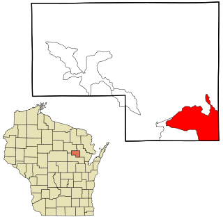
Legend Lake is a census-designated place (CDP) in Menominee County, Wisconsin, Wisconsin, United States, on the Menominee Indian Reservation. The population was 1,670 at the 2020 census.

Star Valley Ranch is a town in Lincoln County, Wyoming, United States. The population was 1,866 at the 2020 census. It was incorporated on November 8, 2005; at the 2000 census, it was only a census-designated place (CDP).

Uhland is a city in Caldwell and Hays counties in the U.S. state of Texas. The population was 1,588 at the 2020 census, up from 1,014 at the 2010 census. Uhland is named after the German poet Ludwig Uhland. Like its neighbor to the north, the city of Niederwald, Uhland was also settled by German emigrants in the 1800s in a region of central Texas known as the Texas-German belt.

