East Dailey, West Virginia | |
|---|---|
 East Dailey  East Dailey | |
| Coordinates: 38°46′49″N79°53′27″W / 38.78028°N 79.89083°W | |
| Country | United States |
| State | West Virginia |
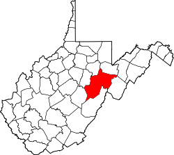
| County | Randolph |
| Area | |
• Total | 1.051 sq mi (2.72 km2) |
| • Land | 1.051 sq mi (2.72 km2) |
| • Water | 0 sq mi (0 km2) |
| Elevation | 1,998 ft (609 m) |
| Population (2020) | |
• Total | 469 |
| • Density | 450/sq mi (170/km2) |
| Time zone | UTC-5 (Eastern (EST)) |
| • Summer (DST) | UTC-4 (EDT) |
| GNIS feature ID | 1554350 [2] |
East Dailey is a census-designated place (CDP) in Randolph County, West Virginia, United States. As of the 2020 census, its population was 469 (down from 557 at the 2010 census). [3] [4] It is located within the Monongahela National Forest adjacent to the Tygart Valley River. East Dailey and its Old Timer's Camp are host to the Elkhenge Music Festival.