Alpena, West Virginia | |
|---|---|
 Alpena  Alpena | |
| Coordinates: 38°54′35″N79°39′04″W / 38.90972°N 79.65111°W | |
| Country | United States |
| State | West Virginia |
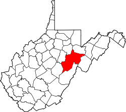
| County | Randolph |
| Elevation | 2,717 ft (828 m) |
| Time zone | UTC-5 (Eastern (EST)) |
| • Summer (DST) | UTC-4 (EDT) |
| GNIS ID | 1553717 [1] |
Alpena is an unincorporated community in Randolph County, West Virginia, United States.
Originally settled as Alpina, the village was located at the foothills of Shaver's Mountain and named after the Swiss Alps because the terrain reminded the settlers of their homeland. Nearby is Spruce Knob, the state's highest elevation, at 4,863 feet. The name Alpina was later corrupted to Alpena, though the exact circumstances of this change are unclear. [2]