Randolph County is a county located in the U.S. state of West Virginia. As of the 2020 census, the population was 27,932. Its county seat is Elkins. The county was founded in 1787 and is named for Edmund Jennings Randolph.

Osceola, named Billy Powell at birth in Alabama, became an influential leader of the Seminole people in Florida. His mother was Muscogee, and his great-grandfather was a Scotsman, James McQueen. He was reared by his mother in the Creek (Muscogee) tradition. When he was a child, they migrated to Florida with other Red Stick refugees, led by a relative, Peter McQueen, after their group's defeat in 1814 in the Creek Wars. There they became part of what was known as the Seminole people.

The Monongahela National Forest is a national forest located in the Allegheny Mountains of eastern West Virginia, USA. It protects over 921,000 acres of federally managed land within a 1,700,000 acres proclamation boundary that includes much of the Potomac Highlands Region and portions of 10 counties.

The Cacapon River, located in the Appalachian Mountains of West Virginia's Eastern Panhandle region, is an 81.0-mile-long (130.4 km) shallow river known for its fishing, boating, wildlife, hunting, and wilderness scenery. As part of the Potomac River watershed, it is an American Heritage River.

The Black Fork is a principal tributary of the Cheat River in the Allegheny Mountains of eastern West Virginia, USA. It is a short stream, about four miles (6 km) in length, formed by the confluence of two other streams not far above its mouth. It was traditionally considered one of the five Forks of Cheat.

The Dry Fork is a 39.1-mile-long (62.9 km) tributary of the Black Fork of the Cheat River in the Allegheny Mountains of eastern West Virginia, USA. Via the Black Fork, the Cheat, and the Monongahela and Ohio rivers, it is part of the watershed of the Mississippi River. The Dry Fork flows for much of its length in the Monongahela National Forest and drains mostly rural and forested areas. It was traditionally considered one of the five Forks of Cheat.
The Potomac Highlands of West Virginia centers on five West Virginian counties in the upper Potomac River watershed in the western portion of the state's Eastern Panhandle, bordering Maryland and Virginia. Because of geographical proximity, similar topography and landscapes, and shared culture and history, the Potomac Highlands region also includes Pocahontas, Randolph, and Tucker counties, even though they are in the Monongahela River or New River watersheds and not that of the Potomac River.

Virginia State Route 311 and West Virginia Route 311 are adjoining state highways in the U.S. states of Virginia and West Virginia. The two state highways together run 58.7 miles (94.5 km) from U.S. Route 11 in Salem, Virginia north to Interstate 64 and U.S. Route 60 near White Sulphur Springs, West Virginia. The two Virginia portions of Route 311 are maintained by the Virginia Department of Transportation, with the exception of the city-maintained portion within Salem. The West Virginia segments are maintained by the West Virginia Division of Highways.

Seneca Creek is a 19.6-mile-long (31.5 km) tributary of the North Fork of the South Branch of the Potomac River located entirely within Pendleton County, West Virginia, USA.

State Route 42 is a primary state highway in the U.S. state of Virginia. Running parallel to and west of Interstate 81, SR 42 consists of three sections, with gaps filled by secondary routes in between. Some of SR 42 lies along the old Fincastle Turnpike. Another major piece, from near Clifton Forge to Buffalo Gap, parallels the old Virginia Central Railroad.

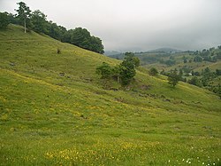
The Sinks of Gandy — also called the Sinks of Gandy Creek, or simply "The Sinks" — are a modestly celebrated cave and underground stream at Osceola in eastern Randolph County, West Virginia, United States. The Sinks are on private property within the Monongahela National Forest.

Newport is an unincorporated community in Giles County, Virginia, United States, with the ZIP code of 24128. It is located in a valley between Salt Pond Mountain, Sherman's Nose and Gap Mountain.
Gandy is a unincorporated community in the northwestern corner of Millard County, Utah, United States, located just east of the Nevada-Utah state line.
Vallscreek is an unincorporated community in McDowell County, West Virginia, United States. Vallscreek is 5.5 miles (8.9 km) south-southeast of War. It was also known as Hartwell.
Laneville is an unincorporated community in Tucker County, West Virginia, United States. It lies on Red Creek along the southern border of the Dolly Sods Wilderness in the Monongahela National Forest.
Litwar is an unincorporated community in McDowell County, West Virginia, United States. Litwar is located on the Tug Fork, 2 miles (3.2 km) west-northwest of Iaeger.
Little Italy is an unincorporated community in Randolph County, West Virginia, United States. Little Italy is located on Gandy Creek and County Route 29/5, 1.3 miles (2.1 km) south of Whitmer and 18.5 miles (29.8 km) east-southeast of Elkins.
Laurel Creek is an unincorporated community and coal town in Fayette County, West Virginia, United States.

The Sinking Creek Valley Cluster is a region in the Jefferson National Forest recognized by The Wilderness Society for its unique recreational and scenic values as well as the importance of its watershed protection for Johns Creek and Craig Creek. Sinking Creek Valley is one of the most scenic valleys in Virginia.