Marmet, West Virginia

Last updated

Town of Marmet
Town
Seal of Marmet, West Virginia.png
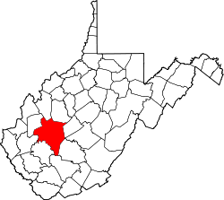
Kanawha County West Virginia Incorporated and Unincorporated areas Marmet Highlighted.svg
Location of Marmet in Kanawha County, West Virginia.
Coordinates: 38°14′43″N81°34′3″W / 38.24528°N 81.56750°W / 38.24528; -81.56750
Country Flag of the United States.svg  United States
State Flag of West Virginia.svg  West Virginia
County Kanawha
Government
  MayorDavid T. Fontalbert
Area
[1]
  Total1.41 sq mi (3.65 km2)
  Land1.27 sq mi (3.30 km2)
  Water0.14 sq mi (0.35 km2)
Elevation
610 ft (186 m)
Population
 (2020) [2]
  Total1,501
  Estimate 
(2021) [2]
1,473
  Density1,072.21/sq mi (414.13/km2)
Time zone UTC-5 (Eastern (EST))
  Summer (DST) UTC-4 (EDT)
ZIP codes
25315, 25365
Area code 304 & 681
FIPS code 54-51724 [3]
GNIS feature ID1542771 [4]
Website townofmarmetwv.com

Marmet (pronounced mar-MET) is a town in Kanawha County, West Virginia, United States, along the Kanawha River. The population was 1,501 at the 2020 census.
Contents

The community was re-named in 1900 after the local Marmet Coal Company, which had the name of its proprietors Edwin and William Marmet. [5] The town name was changed from Brownsville. The town name prior to 1829 was Elizaville that was founded in 1780 by Leonard Morris. [6]

Geography

Marmet is located at 38°14′43″N81°34′3″W / 38.24528°N 81.56750°W / 38.24528; -81.56750 (38.245148, -81.567510). [7]

According to the United States Census Bureau, the town has a total area of 1.41 square miles (3.65 km2), of which 1.27 square miles (3.29 km2) is land and 0.14 square miles (0.36 km2) is water. [8]

Demographics

Historical population
CensusPop.Note
1930 1,200
1940 1,81451.2%
1950 2,51538.6%
1960 2,500−0.6%
1970 2,339−6.4%
1980 2,196−6.1%
1990 1,879−14.4%
2000 1,693−9.9%
2010 1,503−11.2%
2020 1,501−0.1%
2021 (est.)1,473 [2] −1.9%
U.S. Decennial Census [9]

2010 census

As of the census [10] of 2010, there were 1,503 people, 616 households, and 397 families living in the town. The population density was 1,183.5 inhabitants per square mile (457.0/km2). There were 700 housing units at an average density of 551.2 per square mile (212.8/km2). The racial makeup of the town was 96.5% White, 1.6% African American, 0.2% Native American, 0.2% Asian, and 1.5% from two or more races. Hispanic or Latino of any race were 0.3% of the population.

There were 616 households, of which 26.3% had children under the age of 18 living with them, 42.2% were married couples living together, 15.7% had a female householder with no husband present, 6.5% had a male householder with no wife present, and 35.6% were non-families. 30.7% of all households were made up of individuals, and 13.6% had someone living alone who was 65 years of age or older. The average household size was 2.29 and the average family size was 2.83.

The median age in the town was 46.2 years. 18.5% of residents were under the age of 18; 9.4% were between the ages of 18 and 24; 20.6% were from 25 to 44; 28.7% were from 45 to 64; and 23.1% were 65 years of age or older. The gender makeup of the town was 43.5% male and 56.5% female.

Battle of Blair Mountain

In August 1921, thousands of pro-union coal miners organized in Marmet and marched 60 miles to Mingo County through Boone County and then into Logan before entering into Mingo. [11] The aim was an attempt to free striking miners who had been arrested after the governor declared martial law. This confrontation between armed miners’ and the coal companies' army constituted the largest pitched battle in the history of the labor movement in the United States and became the largest insurrection on U.S. soil since the American Civil War. The battle only ended after President Harding called in the army to suppress the uprising. Once the military intervened, the miners laid down their weapons and the fighting ended. [12]

Related Research Articles

<span class="mw-page-title-main">Raleigh County, West Virginia</span> County in West Virginia, United States

Raleigh County is a county in the U.S. state of West Virginia. As of the 2020 census, the population was 74,591. Its county seat is Beckley. The county was founded in 1850 and is named for Sir Walter Raleigh. Raleigh County is included in the Beckley, West Virginia Metropolitan Statistical Area.

<span class="mw-page-title-main">Mingo County, West Virginia</span> County in West Virginia, United States

Mingo County is a county in the U.S. state of West Virginia. As of the 2020 census, the population was 23,568. Its county seat and largest city is Williamson. Created in 1895, Mingo is West Virginia's newest county, named for the historic Iroquoian Mingo people.

<span class="mw-page-title-main">Logan County, West Virginia</span> County in West Virginia, United States

Logan County is a county in the U.S. state of West Virginia. As of the 2020 census, the population was 32,567. Its county seat is Logan. Logan County comprises the Logan, WV Micropolitan Statistical Area, which is also included in the Charleston–Huntington–Ashland, WV–OH–KY Combined Statistical Area.

<span class="mw-page-title-main">Kanawha County, West Virginia</span> County in West Virginia, United States

Kanawha County is a county in the U.S. state of West Virginia. As of the 2020 census, the population was 180,745, making it West Virginia's most populous county. The county seat is Charleston, which is also the state capital and most populous city. Kanawha County is part of the Charleston, WV Metropolitan Statistical Area.

<span class="mw-page-title-main">Boone County, West Virginia</span> County in West Virginia, United States

Boone County is a county in the U.S. state of West Virginia. As of the 2020 census, the population was 21,809. Its county seat is Madison. Boone County is part of the Charleston, WV Metropolitan Statistical Area. Leading industries and chief agricultural products in Boone County include coal, lumber, natural gas, tobacco, and strawberries.

<span class="mw-page-title-main">Whitesville, West Virginia</span> Town in West Virginia, United States

Whitesville is a town and former coal town in Boone County, West Virginia, United States, along the Big Coal River. The population was 361 at the 2020 census. Whitesville was incorporated on August 15, 1935 by the Boone County Circuit Court. The town derives its name from B. W. White, a pioneer settler. Whitesville was formerly known as Jarrold's Valley and Pritchard City.

<span class="mw-page-title-main">Ansted, West Virginia</span> Town in West Virginia, United States

Ansted is a town in Fayette County in the U.S. state of West Virginia. The population was 1,404 at the 2010 census. It is situated on high bluffs along U.S. Route 60 on a portion of the Midland Trail near Hawks Nest overlooking the New River far below.

<span class="mw-page-title-main">Gauley Bridge, West Virginia</span> Town in West Virginia, United States

Gauley Bridge is a town in Fayette County, West Virginia, United States. The population was 614 at the 2010 census. The Kanawha River is formed at Gauley Bridge by the confluence of the New and Gauley Rivers. Two miles to the southwest of Gauley Bridge, in Glen Ferris, is Kanawha Falls, a popular stopping point on Midland Trail Scenic Highway.

<span class="mw-page-title-main">Clendenin, West Virginia</span> Town in West Virginia, United States

Clendenin is a town in Kanawha County, West Virginia, United States, situated along the Elk River. The population was 850 at the 2020 census.

<span class="mw-page-title-main">East Bank, West Virginia</span> Town in West Virginia, United States

East Bank is a town in Kanawha County, West Virginia, United States, situated along the Kanawha River. The population was 820 at the 2020 census. East Bank was incorporated in 1889 by special charter enacted by the West Virginia Legislature. It is so named on account of the town's location on the east side of the Kanawha River.

<span class="mw-page-title-main">Pinch, West Virginia</span> Census-designated place in West Virginia, United States

Pinch is a census-designated place (CDP) in Kanawha County, West Virginia, United States. The population was 3,262 at the 2010 census.

<span class="mw-page-title-main">Pratt, West Virginia</span> Town in West Virginia, United States

Pratt is a town in Kanawha County, West Virginia, United States, along the Kanawha River. The population was 482 at the 2020 census.

<span class="mw-page-title-main">Leon, West Virginia</span> Town in West Virginia, United States

Leon is a town in Mason County, West Virginia, United States, situated along the Kanawha River. The population was 137 at the 2020 census. It is part of the Point Pleasant, WV–OH Micropolitan Statistical Area.

<span class="mw-page-title-main">Gilbert, West Virginia</span> Town in West Virginia, United States

Gilbert is a town in Mingo County, West Virginia, United States, along the Guyandotte River. The population was 333 at the 2020 census. Gilbert was incorporated in 1918 and named for Gilbert Creek, which derives its name from the name of an early traveler in the area who was killed by Native Americans. Gilbert is known nationwide for the Hatfield-McCoy ATV Trails that are located in the area. There are a number of lodges and restaurants in Gilbert.

<span class="mw-page-title-main">Matewan, West Virginia</span> Town in West Virginia, United States

Matewan is a town in Mingo County, West Virginia, United States at the confluence of the Tug Fork River and Mate Creek. The population was 412 at the 2020 census, down from 499 in 2010. The Norfolk Southern Railway's Pocahontas District passes through the town. It was a key site of the Coal Wars and the location of the Battle of Matewan in 1920.

<span class="mw-page-title-main">Buffalo, West Virginia</span> Town in West Virginia, United States

Buffalo is a town in Putnam County, West Virginia, United States, located along the Kanawha River. The population was 1,211 at the time of the 2020 census It is part of the Huntington–Ashland metropolitan area.

<span class="mw-page-title-main">Stanaford, West Virginia</span> Census-designated place in West Virginia, United States

Stanaford is a census-designated place (CDP) and coal town in Raleigh County, West Virginia, United States. The population was 1,350 at the 2010 census.

<span class="mw-page-title-main">Montgomery, West Virginia</span> City in West Virginia

Montgomery is a city in West Virginia, along the Kanawha River. Most of the city is in Fayette County, with the remainder in Kanawha County. The population was 1,280 at the 2020 census.

<span class="mw-page-title-main">Smithers, West Virginia</span> Place in West Virginia, United States

Smithers is a city in Fayette and Kanawha counties in the U.S. state of West Virginia. Located along the Kanawha River, it lies almost entirely in Fayette County. The population was 751 at the 2020 census. The city most likely takes its name from Smithers Creek. The small river city is noted for having a rich cultural history related to both its coal mining and Italian-American heritages.

<span class="mw-page-title-main">Tornado, West Virginia</span> Census-designated place in West Virginia, United States

Tornado, also called Upper Falls, is a census-designated place (CDP) in Kanawha County, West Virginia, United States.

References

  1. "2019 U.S. Gazetteer Files". United States Census Bureau. Retrieved August 7, 2020.
  2. 1 2 3 "City and Town Population Totals: 2020-2021". Census.gov. US Census Bureau. Retrieved July 3, 2022.
  3. "U.S. Census website". United States Census Bureau . Retrieved January 31, 2008.
  4. "US Board on Geographic Names". United States Geological Survey. October 25, 2007. Retrieved January 31, 2008.
  5. Kenny, Hamill (1945). West Virginia Place Names: Their Origin and Meaning, Including the Nomenclature of the Streams and Mountains. Piedmont, WV: The Place Name Press. p. 403.
  6. Explorer Magazine, WV. "Marmet, West Virginia". wvexplorer.com. WV Explorer Magazine. Retrieved February 2, 2022.
  7. "US Gazetteer files: 2010, 2000, and 1990". United States Census Bureau. February 12, 2011. Retrieved April 23, 2011.
  8. "US Gazetteer files 2010". United States Census Bureau. Archived from the original on January 25, 2012. Retrieved January 24, 2013.
  9. "Census of Population and Housing". Census.gov. Retrieved June 4, 2015.
  10. "U.S. Census website". United States Census Bureau . Retrieved January 24, 2013.
  11. "Men Don't Know Why They Fight". The West Virginian. No. Friday Evening Copy. The West Virginian. newspapers.com. September 2, 1921. Retrieved February 2, 2022.
  12. Park Service, National. "Introduction to the West Virginia Mine Wars". National Park Service. National Park Service. Retrieved February 2, 2022.