
Charleston is the capital and most populous city of the U.S. state of West Virginia. Located at the confluence of the Elk and Kanawha rivers, the city had a population of 51,400 at the 2010 census and an estimated population of 46,536 in 2019. The Charleston metropolitan area as a whole had an estimated 208,089 residents in 2019. Charleston is the center of government, commerce, and industry for Kanawha County, of which it is the county seat.
Interstate 79 (I-79) is an Interstate Highway in the eastern United States, designated from I-77 in Charleston, West Virginia to Pennsylvania Route 5 and PA 290 in Erie, Pennsylvania. It is a primary thoroughfare through western Pennsylvania and West Virginia, and makes up part of an important corridor to Buffalo, New York, and the border with Canada. Major metropolitan areas connected by I-79 include Charleston and Morgantown in West Virginia, and Pittsburgh, and Erie in Pennsylvania. In West Virginia, I-79 is known as the Jennings Randolph Expressway, named for Jennings Randolph. In the three most northern counties it is signed as part of the High Tech Corridor. For most of its Pennsylvania stretch, it is known as the Raymond P. Shafer Highway, named for Raymond P. Shafer.

Kanawha County is a county in the U.S. state of West Virginia. As of the 2019 American Community Survey, the population was 183,279. This was a decrease of 9,784 since the 2010 Census; nevertheless, it is West Virginia's most populous county. The county seat is Charleston, which is also the state capital. Kanawha County is part of the Charleston, WV Metropolitan Statistical Area.
Interstate 64 (I-64) is an east–west Interstate Highway in the Eastern United States. Its western terminus is at I-70, U.S. Route 40 (US 40), and US 61 in Wentzville, Missouri. Its eastern terminus is at an interchange with I-264 and I-664 at Bowers Hill in Chesapeake, Virginia. I-64 connects the major metropolitan areas of St. Louis, Missouri, Louisville and Lexington in Kentucky, Charleston, West Virginia, and Richmond and Hampton Roads in Virginia. At 953.74 miles, I-64 is the second longest interstate highway not ending with a 5 or 0, after I-94.

Sissonville is a census-designated place (CDP) in Kanawha County, West Virginia, United States, along the Pocatalico River. The population was 4,028 at the 2010 census. Sissonville is located within 14 miles of Charleston, the state capital.

Red House is a small unincorporated community located in Putnam County in the U.S. state of West Virginia. The community is divided into two distinct areas: Red House (Proper) which follows the Kanawha River Valley along WV 62, and Red House Hill along WV 34 which is in the hills just off the Kanawha River Valley. The Red House Post Office is still in service and was founded on September 26, 1840. Some say the town was named for a red house which stood at the town site, while others believe nearby red rock formations account for the name.

The Kanawha River is a tributary of the Ohio River, approximately 97 mi (156 km) long, in the U.S. state of West Virginia. The largest inland waterway in West Virginia, its valley has been a significant industrial region of the state since early in the 19th century.

The Little Kanawha River is a tributary of the Ohio River, 169 mi (269 km) long, in western West Virginia in the United States. Via the Ohio, it is part of the watershed of the Mississippi River, draining an area of 2,320 mi² (6,009 km²) on the unglaciated portion of the Allegheny Plateau. It served as an important commercial water route in the early history of West Virginia, particularly in the logging and petroleum industries.
U.S. Route 119 (US 119) is a spur of US 19. It is a north–south route that was an original United States highway of 1926. It is Corridor G of the Appalachian Development Highway System (ADHS) east of US 23 and KY 80 in Kentucky to Interstate 64 at Charleston, West Virginia.
Marshall University – South Charleston Campus is a non-residential branch campus of Marshall University located in South Charleston, West Virginia, which is primarily focused on extension graduate programs.
Institute is an unincorporated community on the Kanawha River in Kanawha County, West Virginia, United States. Interstate 64 and West Virginia Route 25 pass by the community, which has grown to intermingle with nearby Dunbar. As of 2018, the community had a population of 1489, 54% of whom were African American.

The Charleston Metropolitan Statistical Area, as defined by the United States Census Bureau, is an area consisting of three counties in West Virginia, anchored by the city of Charleston. It is the largest metropolitan area entirely within the state of West Virginia. While the Huntington Metro Area is more populous, it spans three states, and the core county of the Charleston area, Kanawha County, is more populous than the West Virginia portion of the Huntington area.
Interstate 77 (I-77) in the U.S. state of West Virginia is a major north–south Interstate Highway. It extends for 187.21 miles (301.29 km) between Bluefield at the Virginia state line and Williamstown at the Ohio state line.
Interstate 64 (I-64) is an Interstate Highway in the U.S. state of West Virginia. It travels through the state for 184 miles (296 km) passing by the major towns and cities of Huntington, Charleston, Beckley, and Lewisburg.
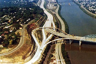
The roads of Charleston, West Virginia, include three major interstate highways, several U.S. highways and state routes, and numerous major thoroughfares.
Mink Shoals is an unincorporated community along U.S. Route 119 in Kanawha County, West Virginia, United States and can be accessed by Interstate 79, Exit 1. It is located on the Elk River and has a public access site of the Elk River. Its rural-like feel attracts many residents, although it is only slightly over two miles from the Charleston city limits. It is located at an altitude of 571 feet (174 m). It also has an elementary school, Shoals Elementary.
Kanawha City is a neighborhood of the city of Charleston in Kanawha County, West Virginia, United States. It is in the southeastern part of the city, and located along WV 61 It officially starts at the 35th Street bridge, where there is a sign welcoming visitors and B&D Gastropub is located. It comprises mostly small stores and neighborhood/residential on both sides. The stores, malls, and restaurants are mostly located in the southern part of the neighborhood.

BridgeValley Community and Technical College (BVCTC) is a multi-campus community and technical college serving the Charleston, West Virginia metropolitan area. It was formed in 2014 by the merger of Bridgemont Community and Technical College of Montgomery, West Virginia and Kanawha Valley Community and Technical College of South Charleston, West Virginia. Its current president is Eunice Bellinger.

The Elk River chemical spill occurred on January 9, 2014 when crude 4-Methylcyclohexanemethanol (MCHM) was released from a Freedom Industries facility into the Elk River, a tributary of the Kanawha River, in Charleston in the U.S. state of West Virginia.


