
Charleston is the capital and most populous city of the U.S. state of West Virginia and the seat of Kanawha County. Located at the confluence of the Elk and Kanawha rivers, the city had a population of 48,864 at the 2020 census and an estimated population of 48,018 in 2021. The Charleston metropolitan area had 308,248 residents in 2020.

Mason County is a county in the U.S. state of West Virginia. As of the 2020 census, the population was 25,453. Its county seat and largest city is Point Pleasant. The county was founded in 1804 and named for George Mason, delegate to the U.S. Constitutional Convention. Before the Civil War, the county was in the State of Virginia.

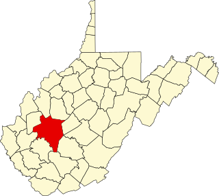
Kanawha County is a county in the U.S. state of West Virginia. As of the 2020 census, the population was 180,745, making it West Virginia's most populous county. The county seat is Charleston, which is also the state capital and most populous city. Kanawha County is part of the Charleston, WV Metropolitan Statistical Area.

The Kanawha River is a tributary of the Ohio River, approximately 97 mi (156 km) long, in the U.S. state of West Virginia. The largest inland waterway in West Virginia, its watershed has been a significant industrial region of the state since early in the 19th century.

The Little Kanawha River is a tributary of the Ohio River, 169 mi (269 km) long, in western West Virginia in the United States. Via the Ohio, it is part of the watershed of the Mississippi River, draining an area of 2,320 mi2 (6,009 km2) on the unglaciated portion of the Allegheny Plateau. It served as an important commercial water route in the early history of West Virginia, particularly in the logging and petroleum industries.

The James River and Kanawha Canal was a partially built canal in Virginia intended to facilitate shipments of passengers and freight by water between the western counties of Virginia and the coast. Ultimately its towpath became the roadbed for a rail line following the same course.

Magic Island is an island in the Kanawha River near its confluence with the Elk River in Charleston, West Virginia. Kanawha Boulevard separates Magic Island from Charleston's West Side neighborhood. It serves as a public park for the city. The island gained its name due to the rise and fall of the river level in the Kanawha, which caused the island to slip underwater, as if by "magic".
Transport in the U.S. state of West Virginia is handled by the West Virginia Department of Transportation (WVDOT) which employs more than 6,000 in West Virginia.
The 5th West Virginia Infantry Regiment was an infantry regiment that served in the Union Army during the American Civil War.
This is a list of the National Register of Historic Places listings in Kanawha County, West Virginia.
Kanawha Falls is an unincorporated community in Fayette County, West Virginia, United States. Kanawha Falls is located on the east bank of the Kanawha River, 2 miles (3.2 km) southwest of Gauley Bridge and 0.6 miles (0.97 km) downstream from the waterfall of the same name. Kanawha Falls had a post office, which opened on March 26, 1856, and closed on November 2, 2002.
Diamond is an unincorporated community in Kanawha County, West Virginia, United States. Diamond is located on the north bank of the Kanawha River, 1.5 miles (2.4 km) southeast of Belle. The community is served by U.S. Route 60.
Dickinson, also known as Quincy, is an unincorporated community in Kanawha County, West Virginia, United States. Dickinson is located on the north bank of the Kanawha River, 3 miles (4.8 km) southeast of Belle. The community is served by U.S. Route 60.
Joplin is an unincorporated community in Kanawha County, West Virginia, United States. It is likely named after an early white settler in Kanawha County, James Jopling. In the early 19th century, Jopling purchased land alongside the creek later called Joplin Branch, a tributary of the Kanawha River. Many of Jopling's children and grandchildren lived along the creek near the family patriarch, and gave the community its name. James Jopling was described as "a man of powerful frame, and loved adventure. He was a noted trapper, hunter, and Indian fighter, and delighted in relating his narrow escapes and wonderful feats in woods life." Jopling also reportedly killed the last elk in the region, nearby on the Elk River.
Sandy, West Virginia may refer to the following unincorporated communities:
Otis Kermit Rice was an American academic historian specializing in West Virginia history. His career was mostly at the West Virginia Institute of Technology (1957–87) at Montgomery where he was chairman of the history department and dean of the School of Human Studies. In 2003 he became West Virginia’s first Historian Laureate.

Cologne Magisterial District is one of ten magisterial districts in Mason County, West Virginia, United States. The district was originally established as a civil township in 1863, and converted into a magisterial district in 1872. In 2020, Cologne District was home to 1,413 people.

The Western Magisterial District is one of three magisterial districts in Jackson County, West Virginia, United States. It was established during a process of redistricting undertaken in the 1990s. In 2010, 10,576 people lived in the district.


