Cedar Grove, West Virginia

Last updated

Cedar Grove, West Virginia
Nickname: 
The Grove "G-Town"
Motto: 
We Can Supply Your Every Need
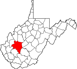
Kanawha County West Virginia Incorporated and Unincorporated areas Cedar Grove Highlighted.svg
Location of Cedar Grove in Kanawha County, West Virginia.
Coordinates: 38°13′12″N81°25′46″W / 38.22000°N 81.42944°W / 38.22000; -81.42944
Country United States
State West Virginia
County Kanawha
Area
[1]
  Total0.72 sq mi (1.86 km2)
  Land0.72 sq mi (1.86 km2)
  Water0.00 sq mi (0.00 km2)
Elevation
614 ft (187 m)
Population
 (2020) [2]
  Total714
  Estimate 
(2021) [2]
700
Time zone UTC-5 (Eastern (EST))
  Summer (DST) UTC-4 (EDT)
ZIP code
25039
Area code 304
FIPS code 54-13924 [3]
GNIS feature ID1537132 [4]
Website https://townofcedargrovewv.com/

Cedar Grove is a town in Kanawha County, West Virginia, United States. The population was 714 at the 2020 census. [2] Cedar Grove was incorporated in 1902. Its name is derived from the time the town was established, when a large juniper forest, misidentified as cedars by early settlers, was growing at that location. Cedar Grove is the site of Fort Kelley and the oldest settlement in the Kanawha Valley, dating from 1773. Landmarks located here include the Tompkins Home (1844) and the Old Brick Church (1853). [5] The current mayor is as of July 1, 2023, is Melissa (Missy) Young.

Contents

Geography

Cedar Grove is located at 38°13′12″N81°25′46″W / 38.22000°N 81.42944°W / 38.22000; -81.42944 (38.220096, -81.429449). [6]

According to the United States Census Bureau, the town has a total area of 0.72 square miles (1.86 km2), all land. [7]

Demographics

Historical population
CensusPop.Note
1910 679
1920 91835.2%
1930 1,11020.9%
1940 1,41127.1%
1950 1,73823.2%
1960 1,569−9.7%
1970 1,275−18.7%
1980 1,47916.0%
1990 1,213−18.0%
2000 862−28.9%
2010 99715.7%
2020 714−28.4%
2021 (est.)700 [2] −2.0%
U.S. Decennial Census [8]

2010 census

As of the census [9] of 2010, there were 997 people, 400 households, and 279 families living in the town. The population density was 1,384.7 inhabitants per square mile (534.6/km2). There were 447 housing units at an average density of 620.8 per square mile (239.7/km2). The racial makeup of the town was 96.6% White, 1.4% African American, 0.2% Native American, 0.1% Asian, 0.2% from other races, and 1.5% from two or more races. Hispanic or Latino of any race were 0.9% of the population.

There were 400 households, of which 34.3% had children under the age of 18 living with them, 46.5% were married couples living together, 16.5% had a female householder with no husband present, 6.8% had a male householder with no wife present, and 30.3% were non-families. 26.0% of all households were made up of individuals, and 15.8% had someone living alone who was 65 years of age or older. The average household size was 2.48 and the average family size was 2.97.

The median age in the town was 39.4 years. 25.1% of residents were under the age of 18; 6.8% were between the ages of 18 and 24; 25% were from 25 to 44; 27% were from 45 to 64; and 15.8% were 65 years of age or older. The gender makeup of the town was 46.4% male and 53.6% female.

2000 census

As of the census [3] of 2000, there were 862 people, 368 households, and 241 families living in the town. The population density was 1,143.8 inhabitants per square mile (443.8/km2). There were 408 housing units at an average density of 541.4 per square mile (210.0/km2). The racial makeup of the town was 98.72% White, 0.93% African American, and 0.35% from two or more races. Hispanic or Latino of any race were 0.23% of the population.

There were 368 households, out of which 28.5% had children under the age of 18 living with them, 42.7% were married couples living together, 15.8% had a female householder with no husband present, and 34.5% were non-families. 31.5% of all households were made up of individuals, and 18.2% had someone living alone who was 65 years of age or older. The average household size was 2.33 and the average family size was 2.90.

In the town, the population was spread out, with 21.6% under the age of 18, 9.7% from 18 to 24, 25.9% from 25 to 44, 21.8% from 45 to 64, and 21.0% who were 65 years of age or older. The median age was 40 years. For every 100 females, there were 90.7 males. For every 100 females age 18 and over, there were 86.7 males.

The median income for a household in the town was $23,250, and the median income for a family was $27,604. Males had a median income of $27,361 versus $22,222 for females. The per capita income for the town was $12,911. About 23.2% of families and 22.9% of the population were below the poverty line, including 30.1% of those under age 18 and 7.9% of those age 65 or over.

Things to do in Cedar Grove

Cedar Grove offers non-handicap fishing access behind Cedar Grove Community School, as well as a park for the youth to play.

Utilities in Cedar Grove

The town of Cedar Grove supplies residents with trash pickup. Electricity for the area is supplied by Appalachian Electric and Power (AEP). Cable services are supplied by Suddenlink Communications, and various satellite providers are available in the area. Cedar Grove Fire Department is volunteer based, with paid emergency medical technicians on the ambulance service.

Related Research Articles

<span class="mw-page-title-main">East Earl Township, Pennsylvania</span> Township in Pennsylvania, United States

East Earl Township is a township in northeastern Lancaster County, Pennsylvania, United States. At the 2020 census, the population was 6,721.

<span class="mw-page-title-main">Cedar Bluff, Alabama</span> Town in Alabama, United States

Cedar Bluff is a town in Cherokee County, Alabama, United States. At the 2020 census, the population was 1,845. Unlike the rest of the county, Cedar Bluff is a wet town. Cedar Bluff is located on the north shore of Weiss Lake, noted for its crappie fishing.

<span class="mw-page-title-main">Cedar Grove, Florida</span> Census-designated place in Florida, United States

Cedar Grove is an unincorporated area and census-designated place in Bay County, Florida, United States. It was formerly an incorporated town, but it was dissolved in 2008 after a vote by residents. The town had 90 days from October 3, 2008, to implement the dissolution ordinance and hand over all operations to organs of the county government. This was the first time in Florida history that a town was disincorporated by a vote of its citizens. The dissolution ordinance took effect at 8:00 AM on October 22, 2008, at which time the police department was disbanded and all assets became the property of the Bay County Commission. The current census-designated place had a population of 3,397 at the 2010 census. It is part of the Panama City–Lynn Haven–Panama City Beach Metropolitan Statistical Area.

<span class="mw-page-title-main">Cedar Grove, Indiana</span> Town in Indiana, United States

Cedar Grove is a town in Highland Township, Franklin County, Indiana, United States. The population was 156 at the 2010 census.

<span class="mw-page-title-main">Mount Auburn, Iowa</span> City in Iowa, United States

Mount Auburn is a city in Benton County, Iowa, United States. The population was 162 at the time of the 2020 census. It is part of the Cedar Rapids Metropolitan Statistical Area.

<span class="mw-page-title-main">Jesup, Iowa</span> City in Iowa, United States

Jesup is a city in Buchanan County and partly in Black Hawk County in the U.S. state of Iowa. The population was 2,508 at the time of the 2020 census. It was named for Morris Ketchum Jesup, president of the Dubuque and Sioux City Railroad.

<span class="mw-page-title-main">Fairfax, Iowa</span> City in Iowa, United States

Fairfax is a city in Linn County, Iowa, United States. The population was 2,828 at the time of the 2020 census. It is part of the Cedar Rapids Metropolitan Statistical Area.

<span class="mw-page-title-main">Cedar Vale, Kansas</span> City in Chautauqua County, Kansas

Cedar Vale is a city in Chautauqua County, Kansas, United States. As of the 2020 census, the population of the city was 476.

<span class="mw-page-title-main">Cedar, Kansas</span> City in Smith County, Kansas

Cedar is a city in Smith County, Kansas, United States. As of the 2020 census, the population of the city was 11.

<span class="mw-page-title-main">Jerico Springs, Missouri</span> Village in Missouri, United States

Jerico Springs is a village in Cedar County, Missouri, United States. The population was 160 at the 2020 census.

<span class="mw-page-title-main">Cedar Rapids, Nebraska</span> Village in Nebraska, United States

Cedar Rapids is a village in Boone County, Nebraska, United States. The population was 382 at the 2010 census.

<span class="mw-page-title-main">Cedar Creek, Nebraska</span> Village in Nebraska, United States

Cedar Creek is a village in Cass County, Nebraska, United States. The population was 465 at the 2020 census.

<span class="mw-page-title-main">Cedar Grove, New Mexico</span> CDP in New Mexico, United States

Cedar Grove is a census-designated place (CDP) in Santa Fe County, New Mexico, United States. It is part of the Santa Fe, New Mexico Metropolitan Statistical Area. The population was 747 at the 2010 census. Cedar Grove was formerly a stage and freight stop. It has developed into a Santa Fe suburb. New Mexico "cedars" are abundant in the town.

<span class="mw-page-title-main">Sugar Grove, Ohio</span> Village in Ohio, United States

Sugar Grove is a village in Fairfield County, Ohio, United States. The population was 429 at the 2020 census.

<span class="mw-page-title-main">Bethel Township, Fulton County, Pennsylvania</span> Township in Pennsylvania, United States

Bethel Township is a township in Fulton County, Pennsylvania, United States. The population was 1,552 at the 2020 census.

<span class="mw-page-title-main">Ladonia, Texas</span> Town in Texas, United States

Ladonia is a town in Fannin County, Texas, United States. Its population was 612 at the 2010 census.

<span class="mw-page-title-main">Chesapeake, West Virginia</span> Town in West Virginia, United States

Chesapeake is a town in Kanawha County, West Virginia, United States. The population was 1,336 at the 2020 census. The town is situated on the Kanawha River.

<span class="mw-page-title-main">Pine Grove, West Virginia</span> Town in West Virginia, United States

Pine Grove is a town in Wetzel County, West Virginia, United States. The population was 363 at the 2020 census. The community was named for a grove of pine trees near the original town site.

<span class="mw-page-title-main">Cedar Rapids, Wisconsin</span> Town in Wisconsin, United States

Cedar Rapids is a town in Rusk County, Wisconsin, United States. The population was 37 at the 2000 census.

<span class="mw-page-title-main">Cedar Grove, Wisconsin</span> Village in Wisconsin, United States

Cedar Grove is a village in Sheboygan County, Wisconsin, United States, within the Town of Holland. The population was 2,101 at the 2020 census. It is included in the Sheboygan, Wisconsin Metropolitan Statistical Area.

References

  1. "2019 U.S. Gazetteer Files". United States Census Bureau. Retrieved August 7, 2020.
  2. 1 2 3 4 "City and Town Population Totals: 2020-2021". Census.gov. US Census Bureau. Retrieved July 3, 2022.
  3. 1 2 "U.S. Census website". United States Census Bureau . Retrieved January 31, 2008.
  4. "US Board on Geographic Names". United States Geological Survey. October 25, 2007. Retrieved January 31, 2008.
  5. "National Register Information System". National Register of Historic Places . National Park Service. July 9, 2010.
  6. "US Gazetteer files: 2010, 2000, and 1990". United States Census Bureau. February 12, 2011. Retrieved April 23, 2011.
  7. "US Gazetteer files 2010". United States Census Bureau. Archived from the original on January 25, 2012. Retrieved January 24, 2013.
  8. "Census of Population and Housing". Census.gov. Retrieved June 4, 2015.
  9. "U.S. Census website". United States Census Bureau . Retrieved January 24, 2013.