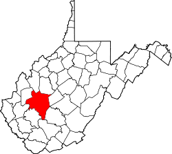
Dial, West Virginia

Last updated
Dial, West Virginia
USA West Virginia location map.svg
Red pog.svg
Dial
Usa edcp location map.svg
Red pog.svg
Dial
Coordinates: 38°25′12″N81°29′11″W / 38.42000°N 81.48639°W / 38.42000; -81.48639 Coordinates: 38°25′12″N81°29′11″W / 38.42000°N 81.48639°W / 38.42000; -81.48639
Country United States
State West Virginia
County Kanawha
Elevation
689 ft (210 m)
Time zone UTC-5 (Eastern (EST))
  Summer (DST) UTC-4 (EDT)
FIPS code 1741879 [1]

Dial is an unincorporated community in Kanawha County, West Virginia, United States.

The community most likely was named after an early settler. [2]

Related Research Articles

Harts, West Virginia Census-designated place in West Virginia, United States

Harts is a census-designated place (CDP) at the mouth of Big Harts Creek in Lincoln County, West Virginia, United States, situated along the Guyandotte River. As of the 2010 census, its population was 656. Harts is a part of the Huntington-Ashland, WV-KY-OH, Metropolitan Statistical Area (MSA). The Harts CDP includes the unincorporated communities of Harts, Atenville, Ferrellsburg, and Sand Creek.

In telecommunications, an overlay plan is a telephone numbering plan that assigns multiple area codes to a geographic numbering plan area (NPA). Overlaying numbering plan area codes is practiced in territories of the North American Numbering Plan (NANP) to prevent exhaustion of telephone numbers and central office codes in growth areas.

Area code 804 Telephone area code in east-central Virginia, United States

North American telephone area code 804 serves the east-central portion of Virginia. The area code is anchored by Virginia's capital, Richmond, and includes most of its metropolitan area. Other communities using 804 include Chesterfield, Henrico, Hopewell, Mechanicsville, Powhatan, Midlothian, Petersburg, and Colonial Heights. The 804 code also includes the Northern Neck and the Middle Peninsula. The two southernmost counties on the Middle Peninsula, Gloucester and Mathews, are part of the Hampton Roads metropolitan area, but use 804 instead of the area code 757 used by the rest of Hampton Roads.

Dial may refer to:

Odd, West Virginia Unincorporated community in West Virginia, United States

Odd is an unincorporated community in Raleigh County, West Virginia, United States. It is located along Tommy Creek.

Emmons, West Virginia Unincorporated community in West Virginia, United States

Emmons is an unincorporated community located on the Big Coal River in Boone and Kanawha counties in the U.S. state of West Virginia. Jay Rockefeller's political affiliation with West Virginia began in 1964-1965 while he served as a VISTA volunteer in Emmons.

Area codes 304 and 681 Area codes of West Virginia

Area codes 304 and 681 are telephone area codes in the North American Numbering Plan (NANP) for the entirety of the U.S. state of West Virginia. The numbering plan area was established in October 1947 with area code 304, as one of the eighty-six original North American area codes. Area code 681 was added to the same area in an overlay plan that took effect on March 28, 2009.

Area codes 301 and 240 North American telephone area codes in Maryland

Area codes 301 and 240 are telephone area codes in the North American Numbering Plan (NANP) for the western part of the U.S. state of Maryland. The numbering plan area (NPA) comprises Maryland's portion of the Greater Washington, D.C. metro area,portions of southern Maryland, along with rural western Maryland. This includes the communities of Cumberland, Frederick, Hagerstown, Gaithersburg, Potomac, Bethesda, Rockville, Landover, Silver Spring, and Waldorf, Maryland.

Area code 810

Area code 810 is a telephone area code in the North American Numbering Plan (NANP) for East Central Michigan. The numbering plan area (NPA) comprises the cities of Flint, Lapeer, Port Huron, and the southern portion of the Thumb.

The following is a set–index article, providing a list of lists, for the cities, towns and villages within the jurisdictional United States. It is divided, alphabetically, according to the state, territory, or district name in which they are located.

The Huntington–Ashland metropolitan area is a metropolitan area in the Appalachian Plateau region of the United States. Referred to locally as the “Tri-State area”, the region spans seven counties in the three states of West Virginia, Kentucky, and Ohio. With a population of 361,580, the Tri-State area is nestled along the banks of the Ohio River. The region offers a diverse range of outdoor activities.

Quick, West Virginia Unincorporated community in West Virginia, United States

Quick is a small unincorporated community in Kanawha County, West Virginia, United States. It is located along Indian Creek Road. The community is where Whitoak Fork and Blue Creek come together and meet. It is also where the abandoned railroad that follows Blue Creek joins the road, and follows it all the way to the community of Hitop, along Pond Fork. Its post office is closed.

Belva, West Virginia Census-designated place in West Virginia, United States

Belva is an unincorporated community and census-designated place in west Nicholas County and north Fayette County, West Virginia, United States; while the CDP only includes the Nicholas County portion, the Fayette County portion is considered part of the community. The town is situated at the bottomland surrounding the convergence of Bells Creek with Twentymile Creek and, subsequently, Twenty Mile Creek with the Gauley River. Belva is also the location of the convergence of two state highways: West Virginia Route 16 and West Virginia Route 39.

Dickinson, West Virginia Unincorporated community in West Virginia, United States

Dickinson, also known as Quincy, is an unincorporated community in Kanawha County, West Virginia, United States. Dickinson is located on the north bank of the Kanawha River, 3 miles (4.8 km) southeast of Belle. The community is served by U.S. Route 60.

Toney, West Virginia Unincorporated community in West Virginia, United States

Toney is an unincorporated community in Lincoln County, West Virginia, United States. Its post office was established in 1904 by Brad Toney, merchant.

Olcott, West Virginia Unincorporated community in West Virginia, United States

Olcott is an unincorporated community and coal town in Kanawha County, West Virginia, United States. Its post office is closed.

Weir, West Virginia Unincorporated community in West Virginia, United States

Weir is an unincorporated community in Kanawha County, West Virginia, United States. Its post office is called Falling Rock.

Legg, West Virginia Unincorporated community in West Virginia, United States

Legg is an unincorporated community in Kanawha County, West Virginia, United States. Its post office is closed.

Wevaco, West Virginia Unincorporated community in West Virginia, United States

Wevaco is an unincorporated community and former coal town in Kanawha County, West Virginia, United States. Its post office is closed.

AT&T Communications, Inc., was a division of the AT&T Corporation that, through 23 subsidiaries, provided interexchange carrier and long-distance telephone services.

References

  1. U.S. Geological Survey Geographic Names Information System: Dial, West Virginia
  2. Kenny, Hamill (1945). West Virginia Place Names: Their Origin and Meaning, Including the Nomenclature of the Streams and Mountains. Piedmont, WV: The Place Name Press. p. 208.