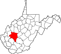
Annfred, West Virginia

Last updated

Annfred, West Virginia
USA West Virginia location map.svg
Red pog.svg
Annfred
Location in West Virginia and the United States
Usa edcp location map.svg
Red pog.svg
Annfred
Annfred (the United States)
Coordinates: 38°18′15″N81°24′49″W / 38.30417°N 81.41361°W / 38.30417; -81.41361
Country United States
State West Virginia
County Kanawha
Elevation
1,217 ft (371 m)
Time zone UTC-5 (Eastern (EST))
  Summer (DST) UTC-4 (EDT)
GNIS ID 1742027 [1]

Annfred is an unincorporated community in Kanawha County, West Virginia, United States.

The name Annfred is a portmanteau of Anna and Fred, honoring a railroad worker and his wife. [2]

Related Research Articles

Palestine may refer to:

<span class="mw-page-title-main">West Virginia</span> U.S. state

West Virginia is a state in the Southern United States. It is bordered by Pennsylvania to the north and east, Maryland to the east and northeast, Virginia to the southeast, Kentucky to the southwest, and Ohio to the northwest. West Virginia is the 10th-smallest state by area and ranks as the 12th-least populous state, with a population of 1,793,716 residents. The capital and largest city is Charleston which has a population of 49,055.

<span class="mw-page-title-main">Huntington, West Virginia</span> City in West Virginia, United States

Huntington is a city in Cabell and Wayne counties in the U.S. state of West Virginia. The county seat of Cabell County, the city is located at the confluence of the Ohio and Guyandotte rivers. Huntington is the second-largest city in West Virginia, with a population of 46,842 as of the 2020 census. Its metro area, the Huntington–Ashland metropolitan area, is the largest in West Virginia, spanning seven counties across three states and having a population of 359,862 at the 2020 census. During the 1900s, the city was a major hub for manufacturing, transportation, and Industrialization. After World War II, due to the shutdown of these industries, the city lost nearly 46% of its population, from a peak of 86,353 in 1950 to 54,844 in 1990. Both the city and metropolitan area declined in population from the 2010 census, a trend that has been ongoing for six decades. It is home to the Port of Huntington Tri-State, the second-busiest inland port in the United States.

<span class="mw-page-title-main">Wheeling, West Virginia</span> City in West Virginia, United States

Wheeling is a city in the U.S. state of West Virginia. Located almost entirely in Ohio County, of which it is the county seat, it lies along the Ohio River in the foothills of the Appalachian Mountains and also contains a tiny portion extending into Marshall County. Wheeling is located about 60 miles (96 km) west of Pittsburgh and is the principal city of the Wheeling metropolitan area. As of the 2020 census, the city had a population of 27,062, and the metro area had a population of 139,513. It is the fifth-largest city in West Virginia, and the largest in the state’s Northern Panhandle.

<span class="mw-page-title-main">West Virginia University</span> Public university in Morgantown, West Virginia, U.S.

West Virginia University (WVU) is a public land-grant research university with its main campus in Morgantown, West Virginia. Its other campuses are those of the West Virginia University Institute of Technology in Beckley, Potomac State College of West Virginia University in Keyser, and clinical campuses for the university's medical and school at Charleston Area Medical Center in Charleston and the Eastern Division at the WVU Medicine Berkeley and Jefferson Medical Centers. WVU Extension Service provides outreach with offices in all 55 West Virginia counties.

<span class="mw-page-title-main">Odd, West Virginia</span> Unincorporated community in West Virginia, United States

Odd is an unincorporated rural hamlet in Raleigh County, West Virginia, United States. It is located along Tommy Creek. Only a post office is located there, with small residences spread along the nearby roads.

<span class="mw-page-title-main">National Register of Historic Places listings in West Virginia</span>

This is a list of properties and historic districts in West Virginia that are listed on the National Register of Historic Places. There are listings in every one of West Virginia's 55 counties.

Emmons is an unincorporated community located on the Big Coal River in Boone and Kanawha counties in the U.S. state of West Virginia. Jay Rockefeller's political affiliation with West Virginia began in 1964–1965 while he served as a VISTA volunteer in Emmons.

The following is a set–index article, providing a list of lists, for the cities, towns and villages within the jurisdictional United States. It is divided, alphabetically, according to the state, territory, or district name in which they are located.

Belva is an unincorporated community and census-designated place in west Nicholas County and north Fayette County, West Virginia, United States; while the CDP only includes the Nicholas County portion, the Fayette County portion is considered part of the community. The town is situated at the bottomland surrounding the convergence of Bells Creek with Twentymile Creek and, subsequently, Twenty Mile Creek with the Gauley River. Belva is also the location of the convergence of two state highways: West Virginia Route 16 and West Virginia Route 39.

Prince is a census-designated place (CDP) in Fayette County, West Virginia, United States. As of the 2010 census, its population was 116. Located at an altitude of 1,263 feet (385 m), it is served by an Amtrak station.

<span class="mw-page-title-main">Outline of West Virginia</span> Overview of and topical guide to West Virginia

The following outline is provided as an overview of and topical guide to the U.S. state of West Virginia:

<span class="mw-page-title-main">Chelyan, West Virginia</span> Census-designated place in West Virginia, United States

Chelyan is a census-designated place (CDP) in Kanawha County, West Virginia, United States. Chelyan is located on the south bank of the Kanawha River, southeast of Chesapeake. It is served by Exit 85 of the West Virginia Turnpike. As of the 2010 census, its population was 776.

Dixie is a census-designated place (CDP) in Fayette and Nicholas counties, West Virginia, United States. Dixie is located on West Virginia Route 16, 5.5 miles (8.9 km) north of Gauley Bridge. Dixie has a post office with ZIP code 25059. As of the 2010 census, its population was 291, with 202 residents in Nicholas County and 89 in Fayette County.

Patterson Creek is a 51.2-mile-long (82.4 km) tributary of the North Branch Potomac River in West Virginia's Eastern Panhandle, in the United States. It enters the North Branch east of Cumberland, Maryland, with its headwaters located in Grant County, West Virginia. Patterson Creek is the watershed for two-thirds of Mineral County, West Virginia. The creek passes through Lahmansville, Forman, Medley, Williamsport, Burlington, Headsville, Reeses Mill, Champwood, and Fort Ashby.

Olcott is an unincorporated community and coal town in Kanawha County, West Virginia, United States. Its post office is closed.

Rensford is an unincorporated community in Kanawha County, West Virginia, United States. Its post office is closed. It was also known as Point Lick.

<span class="mw-page-title-main">Campbells Creek (West Virginia)</span> River in West Virginia, United States

Campbells Creek is a tributary of the Kanawha River, 18.5 miles (29.8 km) long, in West Virginia in the United States. Via the Kanawha and Ohio rivers, it is part of the watershed of the Mississippi River, draining an area of 39.3 square miles (102 km2) on the unglaciated portion of the Allegheny Plateau, in the Charleston metropolitan area.

References

  1. U.S. Geological Survey Geographic Names Information System: Annfred, West Virginia
  2. Kenny, Hamill (1945). West Virginia Place Names: Their Origin and Meaning, Including the Nomenclature of the Streams and Mountains. Piedmont, WV: The Place Name Press. p. 81.