
Red House is a small unincorporated community located in Putnam County in the U.S. state of West Virginia. The community is divided into two distinct areas: Red House (Proper) which follows the Kanawha River Valley along WV 62, and Red House Hill along WV 34 which is in the hills just off the Kanawha River Valley. The Red House Post Office is still in service and was founded on September 26, 1840. Some say the town was named for a red house which stood at the town site, while others believe nearby red rock formations account for the name.

The Little Kanawha River is a tributary of the Ohio River, 169 mi (269 km) long, in western West Virginia in the United States. Via the Ohio, it is part of the watershed of the Mississippi River, draining an area of 2,320 mi² (6,009 km²) on the unglaciated portion of the Allegheny Plateau. It served as an important commercial water route in the early history of West Virginia, particularly in the logging and petroleum industries.
Rada is an unincorporated community in Hampshire County in the U.S. state of West Virginia. Rada is located on U.S. Highway 220/West Virginia Route 28 between Junction and Purgitsville in southwest Hampshire County along Mill Creek. It lies at an intersection of US 220/WV 28 with Rada Road.
Halltown is an unincorporated community on land that was originally owned by William Hall that is along Flowing Springs Run in Jefferson County, West Virginia, United States. Halltown is located off U.S. Route 340 on West Virginia Route 230 between Charles Town and Bolivar. A few houses, a fork in the road, a tiny post office, and the large Halltown Paper Plant are the distinguishing features of the community.
Stumptown is an unincorporated community in Gilmer County, West Virginia, United States, at the confluence of the left and right forks of Steer Creek. It was named for Michael Stump III, a pioneer settler. It lies at an elevation of 725 feet (221 m). The Stumptown Post Office opened May 29, 1883 and closed February 1, 1997.

Left Hand is an unincorporated community in southeastern Roane County, West Virginia, United States. It lies along West Virginia Route 36 southeast of the city of Spencer, the county seat of Roane County. Its post office is still active.
Robson is an unincorporated community in Fayette County, West Virginia, United States, situated primarily on the banks of Loup Creek. Robson is served by State Highway 61, and is located 8 miles (13 km) from Montgomery and 15 miles (24 km) from Oak Hill. Robson's Post Office serves the smaller communities of Beards Fork and Mulberry.
Beards Fork is a census-designated place (CDP) and coal town in Fayette County, West Virginia, United States that was founded as a coal town. As of the 2010 census, its population was 199.
Falling Rock is an unincorporated community in Kanawha County, West Virginia, United States. Falling Rock is located at the confluence of Falling Rock Creek with the Elk River 3 miles (4.8 km) southwest of Clendenin along US Route 19. Falling Rock has a post office with ZIP code 25079.
Lockney is an unincorporated community in Gilmer County, West Virginia, United States. Lockney is located along U.S. Routes 33 and 119 and the Left Fork Steer Creek, 9 miles (14 km) southwest of Glenville. Lockney had a post office, which opened on May 17, 1898, and closed on November 9, 2002. The community was named after H. C. Lockney, a senator who was instrumental in securing for the town a post office.
Liverpool is an unincorporated community in Jackson and Roane counties, West Virginia, United States. Liverpool is located along the Right Fork Sandy Creek at the junction of Jackson County Route 13 and Roane County Route 1, 5.7 miles (9.2 km) west of Reedy Liverpool had a post office, which closed on May 30, 1989. The community was named after Liverpool, in England.
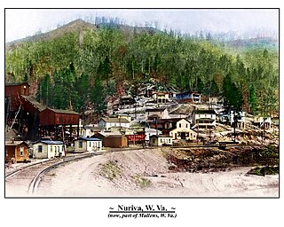
Nuriva is an unincorporated community in Wyoming County, West Virginia, United States.It was also known as Trace Fork and Tracoal. Its post office is closed.
Blue Pennant is an unincorporated community in Boone County, West Virginia. At one time, it was known as Red Dragon, which has closed its post office. Red Dragon as a community was also called Kam and then Mordue.
Fink is an unincorporated community in Lewis County, West Virginia, United States. Its post office is closed.
Sedalia is an unincorporated community in McClellan District, Doddridge County, West Virginia, United States. The community is located along Robinson Fork, a tributary of McElroy Creek. Its former post office is now closed.
Miletus is an unincorporated community in Doddridge County, West Virginia, United States, along Buckeye Creek. Its post office is closed.
Booher is an unincorporated community in Tyler County, West Virginia, United States, along Indian Creek. Its post office is closed.
Sancho was an unincorporated community in Tyler County, West Virginia, United States. Its post office is closed.
Polard is an unincorporated community in Tyler County, West Virginia, United States, along Elk Fork. Its post office is closed.
Flatfork is an unincorporated community in Roane County, in the U.S. state of West Virginia.


