Pratt, West Virginia

Last updated

Pratt, West Virginia
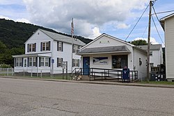
Pratt Historic District 2021a.jpg
Post office in 2021
Logo of Pratt, West Virginia.png
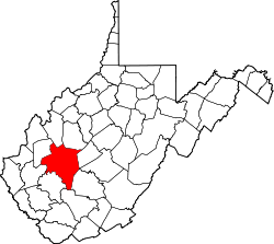
Kanawha County West Virginia Incorporated and Unincorporated areas Pratt Highlighted.svg
Location of Pratt in Kanawha County, West Virginia.
Coordinates: 38°12′26″N81°23′14″W / 38.20722°N 81.38722°W / 38.20722; -81.38722
Country United States
State West Virginia
County Kanawha
Area
[1]
  Total0.29 sq mi (0.76 km2)
  Land0.29 sq mi (0.74 km2)
  Water0.01 sq mi (0.01 km2)
Elevation
633 ft (193 m)
Population
 (2020) [2]
  Total482
  Estimate 
(2021) [2]
471
  Density1,944.06/sq mi (749.59/km2)
Time zone UTC-5 (Eastern (EST))
  Summer (DST) UTC-4 (EDT)
ZIP code
25162
Area code 304
FIPS code 54-65356 [3]
GNIS feature ID1555404 [4]
Website townofpratt.com

Pratt is a town in Kanawha County, West Virginia, United States, along the Kanawha River. The population was 482 at the 2020 census. [2]

Contents

History

The Pratt Historic District is listed on the National Register of Historic Places. [5]

Until its incorporation in 1905, the town was known as Clifton. It was renamed Pratt after the owner of the Charles Pratt Coal Company, Charles Pratt. [6] Many of the structures built by that company, including the miners' clubhouse for and various company houses are still standing. [7]

Geography

Pratt is located at 38°12′26″N81°23′14″W / 38.20722°N 81.38722°W / 38.20722; -81.38722 (38.207149, -81.387354). [8]

According to the United States Census Bureau, the town has a total area of 0.30 square miles (0.78 km2), of which 0.29 square miles (0.75 km2) is land and 0.01 square miles (0.03 km2) is water. [9]

Demographics

Fire station in 2021 Pratt Historic District 2021f.jpg
Fire station in 2021
Historical population
CensusPop.Note
1910 306
1920 3152.9%
1930 3253.2%
1940 41728.3%
1950 4579.6%
1960 60231.7%
1970 67111.5%
1980 82122.4%
1990 640−22.0%
2000 551−13.9%
2010 6029.3%
2019 (est.)556 [10] −7.6%
U.S. Decennial Census [11]

2010 census

As of the census [12] of 2010, there were 602 people, 248 households, and 167 families living in the town. The population density was 2,075.9 inhabitants per square mile (801.5/km2). There were 280 housing units at an average density of 965.5 per square mile (372.8/km2). The racial makeup of the town was 96.5% White, 2.5% African American, 0.2% Native American, 0.2% Asian, and 0.7% from two or more races. Hispanic or Latino of any race were 1.2% of the population.

There were 248 households, of which 27.0% had children under the age of 18 living with them, 52.4% were married couples living together, 11.7% had a female householder with no husband present, 3.2% had a male householder with no wife present, and 32.7% were non-families. 29.4% of all households were made up of individuals, and 14.1% had someone living alone who was 65 years of age or older. The average household size was 2.43 and the average family size was 2.95.

The median age in the town was 41.3 years. 21.8% of residents were under the age of 18; 7.9% were between the ages of 18 and 24; 23.9% were from 25 to 44; 27.6% were from 45 to 64; and 18.6% were 65 years of age or older. The gender makeup of the town was 48.3% male and 51.7% female.

2000 census

As of the census [3] of 2000, there were 551 people, 239 households, and 163 families living in the town. The population density was 1,911.8 inhabitants per square mile (733.6/km2). There were 251 housing units at an average density of 870.9 per square mile (334.2/km2). The racial makeup of the town was 98.00% White, 0.54% African American, 0.18% Asian, 0.18% from other races, and 1.09% from two or more races. Hispanic or Latino of any race were 0.36% of the population.

There were 239 households, out of which 23.8% had children under the age of 18 living with them, 54.4% were married couples living together, 10.0% had a female householder with no husband present, and 31.4% were non-families. 28.5% of all households were made up of individuals, and 16.3% had someone living alone who was 65 years of age or older. The average household size was 2.31 and the average family size was 2.79.

In the town, the population was spread out, with 19.1% under the age of 18, 7.1% from 18 to 24, 27.0% from 25 to 44, 25.2% from 45 to 64, and 21.6% who were 65 years of age or older. The median age was 43 years. For every 100 females, there were 88.7 males. For every 100 females age 18 and over, there were 82.0 males.

The median income for a household in the town was $37,500, and the median income for a family was $42,115. Males had a median income of $31,500 versus $25,208 for females. The per capita income for the town was $18,773. About 5.4% of families and 9.4% of the population were below the poverty line, including 17.1% of those under age 18 and 5.2% of those age 65 or over.
Related Research Articles

<span class="mw-page-title-main">Petrey, Alabama</span> Town in Alabama, United States

Petrey is a town in Crenshaw County, Alabama, United States. The population was 58 at the 2010 census.

<span class="mw-page-title-main">Huslia, Alaska</span> City in Alaska, United States

Huslia is a city in Yukon-Koyukuk Census Area, Alaska, United States. Rarely known as Hussliakatna, it is inhabited by Koyukuk-hotana Athabascans. The population was 293 at the 2000 census and 275 as of the 2010 census.

<span class="mw-page-title-main">Eden, Idaho</span> City in Idaho, United States

Eden is a city in Jerome County, Idaho, United States. The population was 405 at the 2010 census. It is part of the Twin Falls, Idaho Metropolitan Statistical Area.

<span class="mw-page-title-main">St. Olaf, Iowa</span> City in Iowa, United States

St. Olaf is a large village in Clayton County, Iowa, United States. The population was 106 at the time of the 2020 census, down from 136 in 2000. Swiss Valley has a large cheese packaging plant in St. Olaf. There is also a large feed granary, a post office, and a tavern.

<span class="mw-page-title-main">Coats, Kansas</span> City in Pratt County, Kansas

Coats is a city in Pratt County, Kansas, United States. As of the 2020 census, the population of the city was 68. It is located approximately 12 miles southwest of Pratt.

<span class="mw-page-title-main">Pratt, Kansas</span> City in Pratt County, Kansas

Pratt is a city in and the county seat of Pratt County, Kansas, United States. As of the 2020 census, the population of the city was 6,603. It is home to Pratt Community College.

<span class="mw-page-title-main">Preston, Kansas</span> City in Pratt County, Kansas

Preston is a city in Pratt County, Kansas, United States. As of the 2020 census, the population of the city was 115.

<span class="mw-page-title-main">Stockholm, Maine</span> Town in the state of Maine, United States

Stockholm is a town in Aroostook County, Maine, United States. The population was 250 at the 2020 census.

<span class="mw-page-title-main">White Pigeon, Michigan</span> Village in Michigan, United States

White Pigeon is a village in St. Joseph County in the U.S. state of Michigan. The population was 1,718 at the 2020 census. The village is located within White Pigeon Township. Its also located along Michigan's border with Indiana.

<span class="mw-page-title-main">Forestport, New York</span> Town in New York, United States

Forestport is a town in Oneida County, New York, United States. The population was 1,477 at the 2020 census.

<span class="mw-page-title-main">Conesville, New York</span> Town in New York, United States

Conesville is a town in Schoharie County, New York, United States. The population was 687 at the 2020 census. The town is named after Jonathan Cone, an early resident.

<span class="mw-page-title-main">Sheakleyville, Pennsylvania</span> Borough in Pennsylvania, United States

Sheakleyville is a borough in northern Mercer County, Pennsylvania, United States. The population was 142 at the 2010 census, a figure which increased to 150 tabulated residents in 2020. It is part of the Hermitage micropolitan area.

<span class="mw-page-title-main">Blaine Township, Pennsylvania</span> Township in Pennsylvania, United States

Blaine Township is a township in Washington County, Pennsylvania, United States. The population was 619 at the 2020 census.

<span class="mw-page-title-main">Due West, South Carolina</span> Town in South Carolina, United States

Due West is a town in Abbeville County, South Carolina. The population was 1,247 at the 2010 census. It is the home of Erskine College and Dixie High School.

<span class="mw-page-title-main">Millwood, South Carolina</span> CDP in South Carolina, United States

Millwood is a census-designated place (CDP) in Sumter County, South Carolina, United States. The population was 885 at the 2000 census. It is included in the Sumter, South Carolina Metropolitan Statistical Area.

<span class="mw-page-title-main">Moxee, Washington</span> City in Washington, United States

Moxee is a small suburban community southeast of Yakima, Washington. Yakima and Moxee are both north of the Yakama Indian Reservation in Yakima County, Washington, United States. The population of Moxee was 4,326 at the 2020 census.

<span class="mw-page-title-main">Davy, West Virginia</span> Town in West Virginia, United States

Davy is a town in McDowell County, West Virginia, United States. The population was 420 at the 2010 census. Founded in 1873, the town was originally called Hallsville but the name would change to Davy by 1901. Davy was officially incorporated in 1948. It is a mostly residential community in a coal mining district along the main line of the Norfolk Southern Railway.

<span class="mw-page-title-main">Bancroft, West Virginia</span> Town in West Virginia, United States

Bancroft is a town in Putnam County, West Virginia, United States, along the Kanawha River. The population was 389 at the 2020 census. It is part of the Huntington–Ashland metropolitan area.

<span class="mw-page-title-main">Camden-on-Gauley, West Virginia</span> Town in West Virginia, United States

Camden-on-Gauley is a town in Webster County, West Virginia, United States, along the Gauley River. The population was 126 at the 2020 census.

<span class="mw-page-title-main">Schoepke, Wisconsin</span> Town in Wisconsin, United States

Schoepke is a town in Oneida County, Wisconsin, United States. The population was 352 at the 2000 census. The unincorporated communities of Jennings, Lennox, Pelican Lake, and Pratt Junction are located in the town.

References

  1. "2019 U.S. Gazetteer Files". United States Census Bureau. Retrieved August 7, 2020.
  2. 1 2 3 "City and Town Population Totals: 2020-2021". Census.gov. US Census Bureau. Retrieved July 3, 2022.
  3. 1 2 "U.S. Census website". United States Census Bureau . Retrieved January 31, 2008.
  4. "US Board on Geographic Names". United States Geological Survey. October 25, 2007. Retrieved January 31, 2008.
  5. "National Register Information System". National Register of Historic Places . National Park Service. July 9, 2010.
  6. Kenny, Hamill (1945). West Virginia Place Names: Their Origin and Meaning, Including the Nomenclature of the Streams and Mountains. Piedmont, WV: The Place Name Press. p. 507.
  7. "A Brief History of Pratt, WV 1781-1913". April 19, 2011. Retrieved May 5, 2013.
  8. "US Gazetteer files: 2010, 2000, and 1990". United States Census Bureau. February 12, 2011. Retrieved April 23, 2011.
  9. "US Gazetteer files 2010". United States Census Bureau. Archived from the original on January 25, 2012. Retrieved January 24, 2013.
  10. "Population and Housing Unit Estimates". United States Census Bureau. May 24, 2020. Retrieved May 27, 2020.
  11. "Census of Population and Housing". Census.gov. Retrieved June 4, 2015.
  12. "U.S. Census website". United States Census Bureau . Retrieved January 24, 2013.