Acme, West Virginia

Last updated
Acme, West Virginia
USA West Virginia location map.svg
Red pog.svg
Acme
Location in West Virginia and the United States
Usa edcp location map.svg
Red pog.svg
Acme
Acme (the United States)
Coordinates: 38°2′12″N81°27′20″W / 38.03667°N 81.45556°W / 38.03667; -81.45556 Coordinates: 38°2′12″N81°27′20″W / 38.03667°N 81.45556°W / 38.03667; -81.45556
Country United States
State West Virginia
County Kanawha
Elevation
709 ft (216 m)
Time zone UTC-5 (Eastern (EST))
  Summer (DST) UTC-4 (EDT)
GNIS ID 1553689 [1]

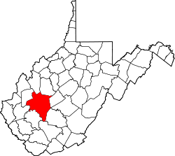
Acme is an unincorporated community in Kanawha County, West Virginia, United States.

Related Research Articles

USS <i>Abarenda</i> (IX-131)

The second USS Abarenda (IX-131) was a storage tanker, one of many miscellaneous-class Navy vessel manned by the United States Coast Guard during World War II.

Hu Maxwell

Hu Maxwell was a local historian, novelist, editor, poet, and author of several histories of West Virginia counties.

Big Ugly Wildlife Management Area

Big Ugly Wildlife Management Area is located on 3,061 acres (1,239 ha) near Logan in Lincoln County, West Virginia. The Big Ugly's steep terrain is covered with mixed hardwoods second growth woodlands. Camping is not allowed at Big Ugly WMA, but is available at nearby Chief Logan State Park.

Hilbert Wildlife Management Area

Hilbert Wildlife Management Area is located in Lincoln County near Sod, West Virginia, less than forty-five minutes drive south of Charleston, the state capital. Located on 289 acres (117 ha), the WMA land is steep and heavily covered with second growth hickory-oak hardwood forest.

Hillcrest Wildlife Management Area

Hillcrest Wildlife Management Area is located in Hancock County near New Cumberland, West Virginia. Located on 2,212 acres (895 ha) of former farmland, the flat bottoms and rolling hills provide open fields, old orchards and small forest lots.

Meadow River Wildlife Management Area

Meadow River Wildlife Management Area, is located near Rupert, West Virginia in Greenbrier County. Occupying 2,385 acres (965 ha) of river bottomland, the WMA is located along the Meadow River and consists mainly of wetlands habitat.

Mill Creek Wildlife Management Area

Mill Creek Wildlife Management Area is 1,470 acres (590 ha) of steeply forested woodlands located near Milton, West Virginia in Cabell County. Mill Creek WMA can be accessed from Johns Creek Road about three miles north from the Milton exit of I-64.

Morris Creek Wildlife Management Area

Morris Creek Wildlife Management Area is located near Clendenin, West Virginia in Clay and Kanawha counties. Located on 9,874 acres (3,996 ha) of steeply forested woodlands, the Morris Creek WMA can be accessed from Morris Creek Road north of Clendenin, or from Leatherwood Creek Road south of Clendenin.

Pruntytown State Farm Wildlife Management Area

Pruntytown State Farm Wildlife Management Area, is located near Pruntytown, West Virginia in Taylor County. The WMA is managed as a beef cattle farm by the West Virginia Department of Agriculture. Located on 1,764 acres (7.14 km2) gently sloping farmland with hay and pasture fields and woodlots on the steeper slopes.

Ritchie Mines Wildlife Management Area

Ritchie Mines Wildlife Management Area, is located near Smithville, West Virginia in Ritchie County. Ritchie Mines WMA is located on 2,300 acres (930 ha) of rugged, hilly woodlands.

Stumptown Wildlife Management Area

Stumptown Wildlife Management Area is located in both Calhoun and Gilmer Counties near the community of Stumptown, West Virginia. Stumptown WMA is located on 1,675 acres (678 ha) of hilly terrain, mostly covered with mixed oak and pine forest, with stands of mixed hardwoods.

Tate Lohr Wildlife Management Area

Tate Lohr Wildlife Management Area, is located in Mercer County near the community of Oakvale, West Virginia. Tate Lohr WMA is located on 500 acres (200 ha) of sloping terrain varying from 2,100 feet (640 m) to 3,500 feet (1,100 m).

Thorn Creek Wildlife Management Area

Thorn Creek Wildlife Management Area, is located about 7 miles south of Franklin, West Virginia in Pendleton County. Thorn Creek WMA is located on 528 acres (214 ha) of steep terrain along hills above Thorn Creek.

Tug Fork Wildlife Management Area

Tug Fork Wildlife Management Area (WMA) is located about 10 miles northwest of Welch, West Virginia in McDowell County. Tug Fork WMA is located on 2,165 acres (876 ha) of steep terrain along hills above the Tug Fork River. The WMA is heavily forested, primarily with mixed hardwoods and yellow poplar/black cherry forests in the coves. The WMA is accessed from U.S. Route 52 at Premier. Several tracks and jeep trails provide walking access into the Tug Fork WMA from U.S. Route 52.

Turkey Run Wildlife Management Area

Turkey Run Wildlife Management Area, is located immediately north of Ravenswood, West Virginia in Jackson County. Turkey Run WMA is located on 27 acres (11 ha), consisting of a fishing lake and some small wooded hills around the lake.

Upper Deckers Creek Wildlife Management Area

Upper Deckers Creek Wildlife Management Area, is located about 1 mile (1.6 km) north of Reedsville, West Virginia in Preston County. Upper Deckers Creek WMA is located on 56 acres (23 ha), consisting of two small fishing ponds and surrounding forested rolling hills.

Upper Mud River Wildlife Management Area

Upper Mud River Wildlife Management Area, is located about 12 miles (19 km) south of Hamlin, West Virginia in Lincoln County, U.S.A. Upper Mud River WMA is located on 1,425 acres (577 ha) of steeply forested terrain.

Widmeyer Wildlife Management Area

Widmeyer Wildlife Management Area, is located about 3 miles (4.8 km) north of Great Cacapon, West Virginia in Morgan County. Widmeyer WMA is located on 422 acres (171 ha) of upland hills above the Potomac River.

Davin, West Virginia Unincorporated community in West Virginia, United States

Davin is an unincorporated community in Logan County, West Virginia, United States. Davin is located on West Virginia Route 10 and Huff Creek, 3 miles (4.8 km) east-southeast of Man. Davin has a post office with ZIP code 25617. Davin's population is counted as part of the Mallory census-designated place.

Mineral City, West Virginia Unincorporated community in West Virginia, United States

Mineral City is an unincorporated community in Logan County, West Virginia, United States. Mineral City is located along Huff Creek and West Virginia Route 10, 3 miles (4.8 km) east of Man. It is part of the Mallory census-designated place.

References