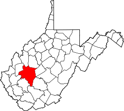
West Dunbar, West Virginia

Last updated

West Dunbar, West Virginia
USA West Virginia location map.svg
Red pog.svg
West Dunbar
Usa edcp location map.svg
Red pog.svg
West Dunbar
Coordinates: 38°22′23″N81°45′19″W / 38.37306°N 81.75528°W / 38.37306; -81.75528
CountryUnited States
State West Virginia
County Kanawha
Area
[1]
  Total0.24 sq mi (0.63 km2)
  Land0.22 sq mi (0.58 km2)
  Water0.02 sq mi (0.05 km2)
Elevation
605 ft (184 m)
Population
 (2020) [2]
617
Time zone UTC-5 (Eastern (EST))
  Summer (DST) UTC-4 (EDT)
ZIP Code
25064 (Dunbar)
Area code(s) 304/681
FIPS code 54-85636
GNIS feature ID2807493 [3]

West Dunbar is an unincorporated community and census-designated place (CDP) in Kanawha County, West Virginia, United States. As of the 2020 census, it had a population of 617. [2]

West Dunbar is in the western part of the county, on the north side of the Kanawha River valley. It is bordered to the south and east by the city of Dunbar. West Virginia Route 25 (Fairlawn Avenue) forms the northeast border of the community. Route 25 leads southeast into Dunbar and east 8 miles (13 km) to Charleston, the state capital, while in the other direction it leads northwest 6 miles (10 km) to Nitro. Interstate 64 runs parallel to Route 25 just outside the CDP; the closest highway access is from Exit 50, 1 mile (1.6 km) to the northwest in Institute, or from Exit 53, 1.5 miles (2.4 km) to the southeast in Dunbar.

Related Research Articles

<span class="mw-page-title-main">Littleton Common, Massachusetts</span> Census-designated place in Massachusetts, United States

Littleton Common is a census-designated place (CDP) in the town of Littleton in Middlesex County, Massachusetts, United States. The population was 3,065 at the 2020 census, up from 2,789 in 2010.

<span class="mw-page-title-main">Wolf Trap, Virginia</span> Census-designated place in Virginia, United States

Wolf Trap is a census-designated place (CDP) in Fairfax County, Virginia, United States. The population was 16,131 at the 2010 census. Wolf Trap National Park for the Performing Arts is located in the CDP.

Salunga is an unincorporated community and census-designated place (CDP) in West Hempfield and East Hempfield townships in Lancaster County, Pennsylvania, United States. As of the 2010 census, the population was 2,695. The community was once part of the Salunga-Landisville CDP, before splitting into two separate CDPs for the 2010 census, the other being Landisville.

<span class="mw-page-title-main">Derry (CDP), New Hampshire</span> Census-designated place in New Hampshire, United States

Derry is a census-designated place (CDP) in the town of Derry in Rockingham County, New Hampshire, United States. The CDP comprises the urban center of the town, as well as the village of East Derry and connected suburban areas. The population of the CDP was 22,879 at the 2020 census, out of 34,317 in the entire town.

McConnell is an unincorporated community and census-designated place (CDP) in Logan County, West Virginia, United States, on the Guyandotte River. As of the 2010 census, its population was 514. It was established in 1933.

Hopeland is a small unincorporated hamlet and census-designated place (CDP) in Lancaster County in the south of the U.S. state of Pennsylvania. The hamlet's ZIP code is 17533. As of the 2010 census the population was 738.

Hutton is an unincorporated community and census-designated place (CDP) in Garrett County, Maryland, United States. Variant names for Hutton include Huttons Switch Station and Kindness.

<span class="mw-page-title-main">Fair Oaks, Fairfax County, Virginia</span> Census-designated place in Virginia, United States

Fair Oaks is a census-designated place in Fairfax County, Virginia, United States. The population as of the 2010 census was 30,223. It encompasses a large area west of the city of Fairfax, centered on Fair Oaks Mall. Suburban neighborhoods and office parks occupy most of Fair Oaks, largely developed since the 1980s.

Mooreville, sometimes misspelled as Mooresville, is an unincorporated community and census-designated place (CDP) in Lee County, Mississippi, United States. As of the 2010 census the population was 650.

Barnet is the primary village and a census-designated place (CDP) in the town of Barnet, Caledonia County, Vermont, United States. As of the 2020 census, the CDP had a population of 127, out of 1,663 in the entire town of Barnet.

Kanauga is an unincorporated community and census-designated place (CDP) in Gallia County, Ohio, United States. As of the 2020 census it had a population of 185.

<span class="mw-page-title-main">Pottery Addition, Ohio</span> Census-designated place in Ohio, United States

Pottery Addition is a census-designated place (CDP) in Jefferson County, Ohio, United States. Its population was 258 as of the 2020 census. The community is located along the Ohio River and is served by Ohio State Route 7.

Woodsville is a hamlet and census-designated place (CDP) in Livingston County, New York, United States. Its population was 70 as of the 2020 census. New York State Route 36 passes through the community.

Goose Creek Village is a census-designated place (CDP) in Loudoun County, Virginia, United States. It was first drawn as a CDP prior to the 2020 census.

<span class="mw-page-title-main">Salem Heights, Columbiana County, Ohio</span> Census-designated place in Ohio, United States

Salem Heights is an unincorporated community and census-designated place (CDP) in Columbiana County, Ohio, United States. It was first listed as a CDP prior to the 2020 census, in which its population was 336. Salem Heights sits on the 1,275-foot (389 m) Blackburn Hill, separated from the city of Salem by the valley of the Middle Fork of the Little Beaver Creek. It is part of the Salem micropolitan area.

Wilkshire Hills is an unincorporated community and census-designated place (CDP) in Tuscarawas County, Ohio, United States. It was first listed as a CDP prior to the 2020 census.

Townshend is the primary village and a census-designated place (CDP) in the town of Townshend, Windham County, Vermont, United States. As of the 2020 census, it had a population of 199, compared to 1,291 in the entire town.

Innovation is an unincorporated area and census-designated place (CDP) in Prince William County, Virginia, United States. As of the 2020 census, it had a population of 926.

Fairfield is an unincorporated community and census-designated place (CDP) in Rockbridge County, Virginia, United States. As of the 2020 census, it had a population of 257.

Erlands Point is an unincorporated community and census-designated place (CDP) in Kitsap County, Washington, United States. As of the 2020 census, it had a population of 916. Prior to 2020, it was part of the Erlands Point-Kitsap Lake CDP.

References

  1. "2020 U.S. Gazetteer Files – West Virginia". United States Census Bureau. Retrieved October 26, 2021.
  2. 1 2 "West Dunbar CDP, West Virginia: 2020 DEC Redistricting Data (PL 94-171)". U.S. Census Bureau. Retrieved October 26, 2021.
  3. "West Dunbar Census Designated Place". Geographic Names Information System . United States Geological Survey, United States Department of the Interior.