
West Virginia is a state in the Appalachian, Mid-Atlantic and Southeastern regions of the United States. It is bordered by Pennsylvania to the northeast, Maryland to the east and northeast, Virginia to the southeast, Kentucky to the southwest, and Ohio to the northwest. West Virginia is the 41st-largest state by area and ranks 38th in population, with a population of 1,795,045 residents. The capital and largest city is Charleston.

Charleston is the capital and most populous city of the U.S. state of West Virginia. Located at the confluence of the Elk and Kanawha rivers, the city had a population of 51,400 at the 2010 census and an estimated population of 46,536 in 2019. The Charleston metropolitan area as a whole had an estimated 208,089 residents in 2019. Charleston is the center of government, commerce, and industry for Kanawha County, of which it is the county seat.

Kanawha County is a county in the U.S. state of West Virginia. As of the 2019 American Community Survey, the population was 183,279. This was a decrease of 9,784 since the 2010 Census; nevertheless, it is West Virginia's most populous county. The county seat is Charleston, which is also the state capital. Kanawha County is part of the Charleston, WV Metropolitan Statistical Area.
West Virginia University (WVU) is a public, land-grant, research university with its main campus in Morgantown, West Virginia. Its other campuses are those of the West Virginia University Institute of Technology in Beckley, Potomac State College of West Virginia University in Keyser, and a second clinical campus for the university's medical and dental schools at Charleston Area Medical Center in Charleston. WVU Extension Service provides outreach with offices in all of West Virginia's 55 counties.
Holly Grove may refer to:

Athleague is a village and a parish in the Diocese of Elphin on the River Suck in the west of Ireland in County Roscommon, near the town of Roscommon.

Hollygrove or sometimes Holly Grove is a townland of 283 acres in Athleague parish, Killeroran district, Killian barony, Union of Mountbellew, in County Galway, Ireland. Hollygrove is adjacent to the townland of Coalpits and is on the border of Roscommon and Galway.
Coalpits or sometimes Coal Pits is a townland of 386 acres in Athleague parish, in Killeroran district, in the Killian barony, the Union of Mountbellew, in County Galway, Ireland. Coalpits, which is known in Irish as Clais an Ghuail, is adjacent to the town of Hollygrove.

The 17th Ward is one of the 17 Wards of New Orleans, a section of the city of New Orleans, Louisiana. New Orleans Districts and Wards. The 17th Ward, along with the 16th, was formed when the City of New Orleans annexed City of Carrollton in 1870.
In 1980 the New Orleans City Planning Commission divided the city into 13 planning districts and 72 distinct neighborhoods. See Orleans Parish neighborhood map
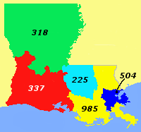
Area code 504 is a telephone area code that covers greater New Orleans, Louisiana. Besides New Orleans itself, it includes all of St. Bernard and Plaquemines parishes and most of Jefferson Parish.
Theryl DeClouet, also known as House Man, was an American soul/R&B singer, best known as the one-time lead vocalist of the musical group Galactic.

Hollygrove is a neighborhood of the city of New Orleans, Louisiana, located in the city's 17th Ward. A subdistrict of the Uptown/Carrollton area, its boundaries as defined by the City Planning Commission are: Palmetto Street to the north, Cambronne, Edinburgh, Forshey, Fig and Leonidas Streets to the east, Earhart Boulevard to the south and the Jefferson Parish boundary to the west. Conrad playground, the Cuccia-Byrnes playground and Larry Gilbert baseball stadium are located in Hollygrove. The Hollygrove Market and Farm is also located in Hollygrove. Notable people, including rapper Lil Wayne, have grown up in the neighborhood.
The Huntington–Ashland metropolitan area is a metropolitan area in the Appalachian Plateau region of the United States. Referred to locally as the “Tri-State area”, the region spans seven counties in the three states of West Virginia, Kentucky, and Ohio. With a population of 361,580, the Tri-State area is nestled along the banks of the Ohio River. The region offers a diverse range of outdoor activities.

Lakewood is a neighborhood of the city of New Orleans. A subdistrict of the Lakeview District Area, its boundaries as defined by the City Planning Commission are: Veterans Memorial Boulevard to the north, Pontchartrain Boulevard and the Pontchartrain Expressway to the east, Last, Quince, Hamilton, Peach, Mistletoe, Dixon, Cherry and Palmetto Streets to the south and the 17th Street Canal to the west.
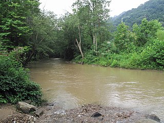
Paint Creek is a 42.1-mile (67.8 km) tributary of the Kanawha River in southern West Virginia. Paint Creek is part of the Mississippi River watershed via the Kanawha and Ohio Rivers and drains an area of 123 square miles (320 km2).
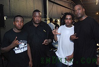
The Chopstars, also known as Chopstar DJs or simply Chopstars, are a collective that include American DJs and turntablists that perform chopped and screwed remixes of popular music including Drake's 2011 Take Care album, as well as Little Dragon's 2014 Nabuma Rubberband album. and recently released Savage Mode II from Metro Boomin and 21 Savage. Created by OG Ron C, the co-founder of Swishahouse Records, it is a homage to the late DJ Screw. The motto of The Chopstars is "Keeping DJ Screw alive since 2001" and "Dedicated to the memory of DJ Screw." Notable members include DJ Candlestick, Mike G, DJ Ryan Wolf the official DJ of the Cleveland Browns, DJ Hollygrove formerly of KQBT, and Academy Award-winning director Barry Jenkins.


