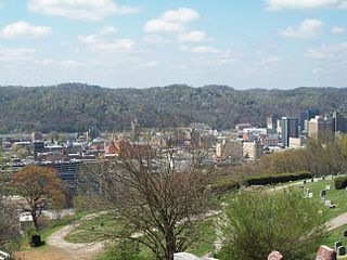
Charleston is the most populous city in, and the capital of, the U.S. state of West Virginia. Located at the confluence of the Elk and Kanawha rivers, the population during the 2016 Census Estimate was 49,138. The Charleston metropolitan area as a whole had 217,916 residents. Charleston is the center of government, commerce, and industry for Kanawha County, of which it is the county seat.

Buffalo is a town in Putnam County, West Virginia, United States, along the Kanawha River. The population was 1,236 at the 2010 census. Buffalo is a part of the Huntington-Ashland, WV-KY-OH, Metropolitan Statistical Area (MSA).

The New River is a river which flows through the U.S. states of North Carolina, Virginia, and West Virginia before joining with the Gauley River to form the Kanawha River at the town of Gauley Bridge, West Virginia. Part of the Ohio River watershed, it is about 360 miles (580 km) long.

The Teays River was a major preglacial river that drained much of the present Ohio River watershed, but took a more northerly downstream course. Traces of the Teays across northern Ohio and Indiana are represented by a network of river valleys. The largest still existing contributor to the former Teays River is the Kanawha River in West Virginia, which is itself an extension of the New River. The name Teays from the Teays Valley is associated with this buried valley since 1910. The more appropriate name would be ancestral Kanawha Valley. The term Teays is used when discussing the buried portion of the ancestral Kanawha River. The Teays was comparable in size to the Ohio River. The River's headwaters were near Blowing Rock, North Carolina; it then flowed through Virginia, West Virginia, Ohio, Indiana and Illinois.. The largest tributary to the Teays River was the Old Kentucky River, which extended from southern Kentucky through Frankfort and subsequently flowed northeast, meeting other tributaries and eventually joining the Teays.

The Kanawha River is a tributary of the Ohio River, approximately 97 mi (156 km) long, in the U.S. state of West Virginia. The largest inland waterway in West Virginia, it has formed a significant industrial region of the state since early in the 19th century.

The Little Kanawha River is a tributary of the Ohio River, 169 mi (269 km) long, in western West Virginia in the United States. Via the Ohio, it is part of the watershed of the Mississippi River, draining an area of 2,320 mi² (6,009 km²) on the unglaciated portion of the Allegheny Plateau. It served as an important commercial water route in the early history of West Virginia, particularly in the logging and petroleum industries.

The Elk River is a tributary of the Kanawha River, 172 miles (277 km) long, in central West Virginia in the United States. Via the Kanawha and Ohio rivers, it is part of the watershed of the Mississippi River.

The Hughes River is a tributary of the Little Kanawha River in western West Virginia in the United States. Via the Little Kanawha and Ohio Rivers, it is part of the watershed of the Mississippi River. As measured from the confluence of its north and south forks, the Hughes is 18 mi (29 km) long, and drains a rural area of the unglaciated portion of the Allegheny Plateau.
Rock Lake is the name of several locations:

Summersville Lake is a reservoir located in the US state of West Virginia. The lake is formed by a rock-fill dam on the Gauley River, south of Summersville in Nicholas County. It is the largest lake in West Virginia, with 2,700 acres (1,100 ha) of water and over 60 miles (97 km) of shoreline at the summer pool water level. Its maximum depth is 327 feet.
The Prehistory of West Virginia spans ancient times until the arrival of Europeans in the early 17th century. Hunters ventured into West Virginia's mountain valleys and made temporary camp villages since the Archaic period in the Americas. Many ancient human-made earthen mounds from various mound builder cultures survive, especially in the areas of Moundsville, South Charleston, and Romney. The artifacts uncovered in these areas give evidence of a village society with a tribal trade system culture that included limited cold worked copper. As of 2009, over 12,500 archaeological sites have been documented in West Virginia.
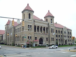
Kanawha County Courthouse is a historic courthouse located at Charleston, West Virginia. It is located across from the Charleston City Hall, and is a block-long structure constructed in 1892 of rock-face masonry.
Boomer is a census-designated place (CDP) in Fayette County, West Virginia, United States. Boomer is located on the north bank of the Kanawha River 2 miles (3.2 km) southeast of Smithers. Boomer has a post office with ZIP code 25031. As of the 2010 census, its population was 615.

Falling Rock is an unincorporated community in Kanawha County, West Virginia, United States. Falling Rock is located at the confluence of Falling Rock Creek with the Elk River 3 miles (4.8 km) southwest of Clendenin along US Route 19. Falling Rock has a post office with ZIP code 25079.
Diamond is an unincorporated community in Kanawha County, West Virginia, United States. Diamond is located on the north bank of the Kanawha River 1.5 miles (2.4 km) southeast of Belle. The community is served by U.S. Route 60.
Kanawha is an unincorporated community in Wood County, West Virginia, USA. Kanawha is located on West Virginia Route 47 7 miles (11 km) southeast of Parkersburg.
Joplin is an unincorporated community in Kanawha County, West Virginia. It is likely named after an early white settler in Kanawha County, James Jopling. In the early 19th century, Jopling purchased land alongside the creek later called Joplin Branch, a tributary of the Kanawha River. Many of Jopling's children and grandchildren lived along the creek near the family patriarch, and gave the community its name. James Jopling was described as "a man of powerful frame, and loved adventure. He was a noted trapper, hunter, and Indian fighter, and delighted in relating his narrow escapes and wonderful feats in woods life." Jopling also reportedly killed the last elk in the region, nearby on the Elk River.
Airport Village is an unincorporated community in Kanawha County, West Virginia.
Weir is an unincorporated community in Kanawha County, West Virginia, United States. Its post office is called Falling Rock.


