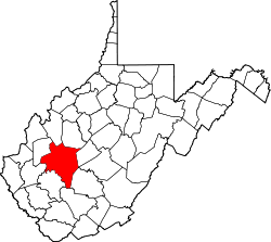
Coco, West Virginia

Last updated

Coco, West Virginia
USA West Virginia location map.svg
Red pog.svg
Coco
Location in West Virginia and the United States
Usa edcp location map.svg
Red pog.svg
Coco
Coco (the United States)
Coordinates: 38°24′11″N81°25′9″W / 38.40306°N 81.41917°W / 38.40306; -81.41917
Country United States
State West Virginia
County Kanawha
Elevation
653 ft (199 m)
Time zone UTC-5 (Eastern (EST))
  Summer (DST) UTC-4 (EDT)
GNIS ID 1549635 [1]

Coco is an unincorporated community in Kanawha County, West Virginia, United States.

The community was originally named Poco, after the name of a rooster in a story, but the spelling was changed in processing by the postal service. Prior to being named "Coco", the community was known as "Elklick", a name that likely started because of the region's elk population. Coco, West Virginia is also home to a cemetery named "Coco Cemetery." It is home to 19 memorials. [2]

Related Research Articles

Coco commonly refers to:

<span class="mw-page-title-main">Three Churches, West Virginia</span> Unincorporated community in West Virginia, United States

Three Churches is an unincorporated community in Hampshire County in the U.S. state of West Virginia. The town is located north of Romney along Jersey Mountain Road at a crossroads with Three Churches Hollow Road. Originally known as Jersey Mountain, Three Churches was renamed for the three historic white wooden churches located there: Mount Bethel Church, Mount Bethel Primitive Baptist Church, and Branch Mountain United Methodist Church. The Three Churches Post Office is no longer in service.

Purgitsville is an unincorporated community in Hampshire County in the U.S. state of West Virginia. According to the 2000 census, the ZCTA for Purgitsville had a population of 813. Purgitsville is located on U.S. Highway 220/West Virginia Route 28 at its intersection with Huffman Road south of Junction. An elementary school, Mill Creek Elementary, was open here until 1993 when it was consolidated with Romney Elementary.

Loom is an unincorporated community in Hampshire County, West Virginia, United States. Loom is located between Capon Bridge and Hanging Rock along the Northwestern Turnpike on the western flanks of Cooper Mountain. Timber Mountain Road and Beck's Gap Road converge at Loom on U.S. Route 50.

<span class="mw-page-title-main">Capon Chapel</span> Historic United Methodist church in West Virginia, U.S.

Capon Chapel, also historically known as Capon Baptist Chapel and Capon Chapel Church, is a mid-19th century United Methodist church located near to the town of Capon Bridge, West Virginia, in the United States. Capon Chapel is one of the oldest existing log churches in Hampshire County, along with Mount Bethel Church and Old Pine Church.

Largent is an unincorporated community village located chiefly in Morgan County and partly in Hampshire County in the U.S. state of West Virginia. Largent is located on the Cacapon River, approximately 18 miles southwest of Berkeley Springs along Cacapon Road. It is located by Old Enon Cemetery, Stony Creek, and the Cacapon River. Largent's original town name was Enon. It was most likely renamed when Postal Service found another town of Enon elsewhere in the state. The Enon name is found in local church and cemetery names. The Enon school is found on USGS maps from 1914 through 1923. The school has been open at least since the 1930s. The Baileys bought the building in 1958 and it has been a residence since.

<span class="mw-page-title-main">Heaters, West Virginia</span> Unincorporated community in West Virginia, United States

Heaters is an unincorporated community in Braxton County, West Virginia, United States. Heaters is situated approximately three miles north of Flatwoods on U.S. Route 19, which is a paved two-lane road. Access from I-79 is at exit 67 in Flatwoods, or exit 79 at Burnsville, then Route 5 to Heaters. There is no stoplight in Heaters. Heaters has a United States Postal Service post office and the ZIP Code is 26627.

<span class="mw-page-title-main">Bandytown, West Virginia</span> Unincorporated community in West Virginia, United States

Bandytown is an unincorporated community in Boone County, West Virginia, United States. Bandytown is approximately 18 miles from Madison. Bandytown is accessible from Boone County Route 26, which is located right off West Virginia Route 85 at the Van Bridge split. The community has a total population of over 100 with approximately 70 homes.

<span class="mw-page-title-main">Bristow, Virginia</span> Unincorporated community in Virginia, United States

Bristow is an unincorporated community of Prince William County in Northern Virginia about 30 miles (48 km) from Washington, D.C. In 2014, Bristow's postal area population was 29,346, a 287% increase since 2000; however, the Bristow community is formally included in the Linton Hall, Virginia census-designated place (CDP).

<span class="mw-page-title-main">Quick, West Virginia</span> Unincorporated community in West Virginia, United States

Quick is a small unincorporated community in Kanawha County, West Virginia, United States. It is located along Indian Creek Road. The community is where Whitoak Fork and Blue Creek come together and meet. It is also where the abandoned railroad that follows Blue Creek joins the road, and follows it all the way to the community of Hitop, along Pond Fork. Its post office is closed.

Sharon is an unincorporated community and coal town in southeastern Kanawha County, West Virginia, United States, located along the West Virginia Turnpike.

Howesville is an unincorporated community and coal town in Preston County, West Virginia, United States. It sits at an altitude of 2,218 feet (676 m). The community once possessed a post office, which has since been closed.

<span class="mw-page-title-main">Mitchell's Brick House Tavern</span> Historic tavern in Virginia, United States

Mitchell's Brick House Tavern, also known as Oakland, Hite House, Goodwin Tavern, Goodwin House and Coco House, is a historic home located at Arrington, Nelson County, Virginia. It is a two-story, painted brick Greek Revival-style house with a raised or English basement, built about 1838. The estate consists of the main house with two additions, several dependencies, a garage, and the small Goodwin Family cemetery.

Key Rock is an unincorporated community in Wyoming County, West Virginia, United States. The community is home to the Coon Fork Church congregation and the Lester Family Cemetery.

<span class="mw-page-title-main">Wadestown, West Virginia</span> Unincorporated community in West Virginia

Wadestown — formerly West Warren — is an unincorporated community in Monongalia County, West Virginia, United States. It is located on West Virginia Route 7, approximately 7.5 miles (12.1 km) west-southwest of Blacksville.

Jodie, also known as Imboden, is an unincorporated community in Fayette County, West Virginia, United States. It is located along the Gauley River at the mouth of Rich Creek, 4 miles (6.4 km) northeast of Gauley Bridge. Due to its proximity to the county line, Jodie is part of the Nicholas County ZIP code of 26690; it had its own post office until its closure on July 23, 2005.

Dillon is an unincorporated community in Raleigh County, West Virginia, United States. It was also known as Irish Mountain and is the location of St. Colman's Roman Catholic Church and Cemetery, which is on the National Register of Historic Places.

Randolph is a historically black middle class neighborhood located within the West End of Richmond, Virginia. The neighborhood is named in honor of Virginia E. Randolph, a former African-American educator in Henrico County, Virginia during the 19th century. The neighborhood is bounded by the Downtown Expressway to the north, Harrison Street to the east, Colorado Avenue to the south, and South Meadow street to the west. Some famous landmarks and places of interest in the neighborhood include Petronius Park, the Randolph Community Center, and just adjacent to the neighborhood, the Hollywood Cemetery.

Basnettville is an unincorporated community in Marion County, in the U.S. state of West Virginia.

References

  1. U.S. Geological Survey Geographic Names Information System: Coco, West Virginia
  2. Kenny, Hamill (1945). West Virginia Place Names: Their Origin and Meaning, Including the Nomenclature of the Streams and Mountains. Piedmont, WV: The Place Name Press. p. 180.