Braxton County is a county in the central part of the U.S. state of West Virginia. As of the 2020 census, the population was 12,447. The county seat is Sutton. The county was formed in 1836 from parts of Lewis, Kanawha, and Nicholas counties and named for Carter Braxton, a Virginia statesman and signer of the Declaration of Independence.
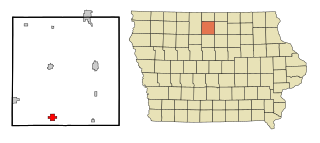
Kanawha is a city in Hancock County, Iowa, United States. The population was 658 at the time of the 2020 census.

Mountainhome is a census-designated place (CDP) in Barrett Township, Monroe County, Pennsylvania, United States. The population was 1,182 at the 2010 census.

Grantsville is a town in Calhoun County, West Virginia, United States. The population was 482 at the 2020 census. It is the county seat of Calhoun County. The town was established along the Little Kanawha River in 1865 and named for Ulysses S. Grant. Grantsville is home to Wayne Underwood Park, which includes a .25-mile-long (0.40 km) walking trail, and to the annual West Virginia Wood Festival.

Gauley Bridge is a town in Fayette County, West Virginia, United States. The population was 614 at the 2010 census. The Kanawha River is formed at Gauley Bridge by the confluence of the New and Gauley Rivers. Two miles to the southwest of Gauley Bridge, in Glen Ferris, is Kanawha Falls, a popular stopping point on Midland Trail Scenic Highway.

Belle is a town in Kanawha County, West Virginia, United States, situated along the Kanawha River. The population was 1,171 at the 2020 census. Belle was incorporated on December 13, 1958, by the Kanawha County Circuit Court. It is the home of the Belle Bulldogs Elementary School.

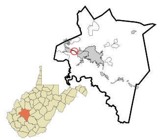
Cedar Grove is a town in Kanawha County, West Virginia, United States. The population was 714 at the 2020 census. Cedar Grove was incorporated in 1902. Its name is derived from the time the town was established, when a large juniper forest, misidentified as cedars by early settlers, was growing at that location. Cedar Grove is the site of Fort Kelley and the oldest settlement in the Kanawha Valley, dating from 1773. Landmarks located here include the Tompkins Home (1844) and the Old Brick Church (1853). The current mayor is as of July 1, 2023, is Melissa (Missy) Young.

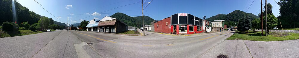
Chesapeake is a town in Kanawha County, West Virginia, United States. The population was 1,336 at the 2020 census. The town is situated on the Kanawha River.

Dunbar is a city in Kanawha County, West Virginia, United States, situated along the Kanawha River. The population was 7,479 at the 2020 census.

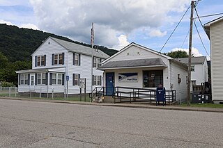
East Bank is a town in Kanawha County, West Virginia, United States, situated along the Kanawha River. The population was 820 at the 2020 census. East Bank was incorporated in 1889 by special charter enacted by the West Virginia Legislature. It is so named on account of the town's location on the east side of the Kanawha River.

Glasgow is a town in Kanawha County, West Virginia, United States, situated along the Kanawha River. The population was 708 at the 2020 census. Glasgow was incorporated on June 20, 1920. Folk etymology derives its name from a combination of the word "glass" with the word "company" for a glass factory that was built there many years ago, but the presence of many Scottish immigrants to this part of Appalachia, particularly from the Strathclyde region, indicates that the town was most likely named after the Scottish city of Glasgow in Strathclyde. Other Virginia and West Virginia locations named for places in Strathclyde include Dumbarton, Argyle, Loudoun County, Hamilton in Loudoun County, Lanark and Renfrew.
Jefferson is a census-designated place (CDP) in Kanawha County, West Virginia, United States, along the Kanawha River. The population was 676 at the 2010 census. Jefferson was incorporated on March 22, 1997, but was disincorporated less than a decade later on February 21, 2007.
Pratt is a town in Kanawha County, West Virginia, United States, along the Kanawha River. The population was 482 at the 2020 census.

St. Albans is a city in western Kanawha County, West Virginia, United States, at the confluence of the Kanawha and Coal rivers. The population was 10,861 at the 2020 census. It is part of the Charleston metropolitan area.

Henderson is an unincorporated community and former town in Mason County, West Virginia, United States, at the confluence of the Ohio and Kanawha Rivers. The population was 231 at the 2020 census. It is part of the Point Pleasant, WV–OH Micropolitan Statistical Area. The town was incorporated in 1893 and named for Samuel Bruce Henderson, who owned the townsite at the time. The town was unincorporated following a public hearing on August 11, 2022.

Leon is a town in Mason County, West Virginia, United States, situated along the Kanawha River. The population was 137 at the 2020 census. It is part of the Point Pleasant, WV–OH Micropolitan Statistical Area.

Bancroft is a town in Putnam County, West Virginia, United States, along the Kanawha River. The population was 389 at the 2020 census. It is part of the Huntington–Ashland metropolitan area.

Buffalo is a town in Putnam County, West Virginia, United States, located along the Kanawha River. The population was 1,211 at the time of the 2020 census It is part of the Huntington–Ashland metropolitan area.

Reedy is a town in Roane County, West Virginia, United States. The population was 152 at the 2020 census.

Montgomery is a city in West Virginia, United States, along the Kanawha River. Most of the city is in Fayette County, with the remainder in Kanawha County. The population was 1,280 at the 2020 census.