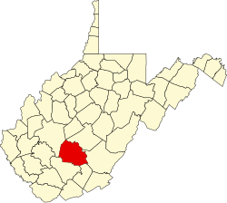
Rush Run, West Virginia

Last updated

Rush Run, West Virginia
USA West Virginia location map.svg
Red pog.svg
Rush Run
Usa edcp location map.svg
Red pog.svg
Rush Run
Coordinates: 37°57′52″N81°3′56″W / 37.96444°N 81.06556°W / 37.96444; -81.06556
Country United States
State West Virginia
County Fayette
Elevation
1,089 ft (332 m)
Time zone UTC-5 (Eastern (EST))
  Summer (DST) UTC-4 (EDT)
GNIS ID 1556191 [1]

Rush Run was an unincorporated community and coal town in Fayette County, West Virginia, United States.

The community takes its name from nearby Rush Run. [2]

See also

Related Research Articles

<span class="mw-page-title-main">Cacapon River</span> River in West Virginia, United States

The Cacapon River, located in the Appalachian Mountains of West Virginia's eastern panhandle region, is an 81.0-mile-long (130.4 km) shallow river known for its fishing, boating, wildlife, hunting, and wilderness scenery. As part of the Potomac River watershed, it is an American Heritage River.

<span class="mw-page-title-main">Capon Springs, West Virginia</span> Unincorporated community in West Virginia, United States

Capon Springs is an unincorporated community in Hampshire County, West Virginia, United States. According to the 2000 census, the Capon Springs community has a population of 95.

<span class="mw-page-title-main">Opequon Creek</span>

Opequon Creek is an approximately 35 mile tributary stream of the Potomac River. It flows into the Potomac northeast of Martinsburg in Berkeley County, West Virginia, and its source lies northwest of the community of Opequon at the foot of Great North Mountain in Frederick County, Virginia. The Opequon forms part of the boundary between Frederick and Clarke counties in Virginia and also partially forms the boundary between Berkeley and Jefferson counties in West Virginia's Eastern Panhandle.

<span class="mw-page-title-main">Cucumber, West Virginia</span> Census-designated place in West Virginia, United States

Cucumber is a census-designated place (CDP) in McDowell County, West Virginia, United States. Its population was 74 at the 2020 census. The community is centered on mining. Named either for nearby Cucumber Creek or for the cucumber trees in the area, it is the only community in the United States with this name. Its post office was still active as of October 2011.

Halltown is an unincorporated community situated along Flowing Springs Run in Jefferson County, West Virginia. Halltown is located off U.S. Route 340 on West Virginia Route 230 between Charles Town and Bolivar. The Halltown Paperboard Mill has operated in the community since 1869.

Kabletown is an unincorporated community in Jefferson County, West Virginia, United States. The town lies along a spring-fed stream called Bullskin Run near the Shenandoah River on Kabletown Road, very close to the border with Virginia. Kabletown's population was 10,073 in 2000.

Files Crossroad is an unincorporated community in Berkeley County, West Virginia, United States. The community is located east of Martinsburg on West Virginia Route 45 at its crossroads with County Route 45/4. The community was originally known as Smoketown, hence the name of its historic Smoketown Cemetery.

Scrabble is an unincorporated community in Berkeley County, West Virginia, United States. According to the Geographic Names Information System, the community has been known as Hard Scrabble, Hard Scrabble Town, and Hardscrabble throughout its history.

<span class="mw-page-title-main">Uneeda, West Virginia</span> Unincorporated community in West Virginia, United States

Uneeda is an unincorporated community on the Pond Fork River in Boone County in the U.S. state of West Virginia. The town lies along West Virginia Route 85.

<span class="mw-page-title-main">Bristow, Virginia</span> Unincorporated community in Virginia, United States

Bristow is an unincorporated community of Prince William County about 30 miles from Washington, D.C. It is situated between Manassas, Virginia and Gainesville, Virginia. As of 2014, the total population was 29,346, a 287% increase since 2000. The Bristow community is formally included in the Linton Hall, Virginia census-designated place (CDP)

The following is a set–index article, providing a list of lists, for the cities, towns and villages within the jurisdictional United States. It is divided, alphabetically, according to the state, territory, or district name in which they are located.

<span class="mw-page-title-main">Charlottesville, Indiana</span> Unincorporated community and Census-designated place in Indiana, United States

Charlottesville is an unincorporated community in Hancock and Rush counties in the U.S. state of Indiana. The Hancock County portion is in Jackson Township, while the Rush County portion is in Ripley Township.

Rush Run is an unincorporated community in Warren Township, Jefferson County, Ohio, United States. It is mainly around the area of Rush Run Road also known as County Road 17. It is named for David Rush who settled in that area in 1798.

Morrisvale is an unincorporated community and coal town in Boone County, West Virginia, United States. Morrisvale is located on County Route 8 and Jack Smith Run, 7 miles (11 km) northwest of Madison.

Burnt House is an unincorporated community in Ritchie County, West Virginia, United States. Burnt House is located on West Virginia Route 47 and Grass Run, 11.8 miles (19.0 km) south-southeast of Harrisville. The Burnt House Post Office closed 5/23/1986.

Booger Hole is an unincorporated community in northern Clay County, West Virginia, United States. It is located in the Rush Fork Valley, near the town of Ivydale.

Miracle Run is an unincorporated community in Monongalia County, West Virginia, United States.

Peeltree — formerly Scoop Town, then Peel Tree — is an unincorporated community in Barbour County, West Virginia, United States.

Coe is an unincorporated community in Nicholas County, West Virginia, United States. Coe is located on County Route 7/6, 5.4 miles (8.7 km) east of Craigsville.

Dunloup or Dunloop is an unincorporated community and coal town in Fayette County, West Virginia, United States.

References

  1. U.S. Geological Survey Geographic Names Information System: Rush Run, West Virginia
  2. Kenny, Hamill (1945). West Virginia Place Names: Their Origin and Meaning, Including the Nomenclature of the Streams and Mountains. Piedmont, WV: The Place Name Press. p. 544.