
The Potomac River is a major river in the Mid-Atlantic region of the United States that flows from the Potomac Highlands in West Virginia to the Chesapeake Bay in Maryland. It is 405 miles (652 km) long, with a drainage area of 14,700 square miles (38,000 km2), and is the fourth-largest river along the East Coast of the United States. More than 6 million people live within its watershed.

WaKeeney is a city in and the county seat of Trego County, Kansas, United States. As of the 2020 census, the population of the city was 1,799.

The Shenandoah River is the principal tributary of the Potomac River, 55.6 miles (89.5 km) long with two forks approximately 100 miles (160 km) long each, in the U.S. states of Virginia and West Virginia. The river and its tributaries drain the central and lower Shenandoah Valley and the Page Valley in the Appalachians on the west side of the Blue Ridge Mountains, in northwestern Virginia and the eastern panhandle of West Virginia. There is a hydroelectric plant along the Shenandoah River constructed in 2014 by Dominion.
Back Creek is a 59.5-mile-long (95.8 km) tributary of the Potomac River that flows north from Frederick County, Virginia, to Berkeley County in West Virginia's Eastern Panhandle. Back Creek originates along Frederick County's border with Hampshire County, West Virginia, at Farmer's Gap in the Great North Mountain. Its name reflects its location to the west of North Mountain. The perspective of colonists from the east in the 18th century led them to call it "Back Creek", because it lay to the back of North Mountain.
Sleepy Creek is a 44.0-mile-long (70.8 km) tributary of the Potomac River in the United States, belonging to the Chesapeake Bay's watershed. The stream rises in Frederick County, Virginia, and flows through Morgan County, West Virginia before joining the Potomac near the community of Sleepy Creek.
The Jug — formerly known as the Jug Handle — is a jug-shaped island formed by a horseshoe bend on Middle Island Creek near Middlebourne in Tyler County, West Virginia, USA. It is maintained by the state of West Virginia as The Jug Wildlife Management Area.

The Battle of Blair Mountain was the largest labor uprising in United States history and is the largest armed uprising since the American Civil War. The conflict occurred in Logan County, West Virginia, as part of the Coal Wars, a series of early-20th-century labor disputes in Appalachia.

Cedar Bluff State Park is a public recreation area located 21 miles (34 km) southeast of WaKeeney and 23 miles (37 km) southwest of Ellis in Trego County, Kansas, United States.

The Weirton–Steubenville, WV–OH Metropolitan Statistical Area, also known as the Upper Ohio Valley, is a metropolitan statistical area consisting of two counties in the Northern Panhandle of West Virginia and one in Ohio, anchored by the cities of Weirton and Steubenville. As of the 2020 census, the MSA had a population of 116,903. This puts it at 334th largest in the United States. It is also included in the larger Pittsburgh–New Castle–Weirton, PA–OH–WV Combined Statistical Area.

Cross Creek Wildlife Management Area, named after Cross Creek which flows through its southern part, is located on 630 acres (250 ha) in Brooke County near Wellsburg, West Virginia. Mixed hardwoods cover most of the former strip mine site. The rolling terrain is punctuated with a few highwalls and ponds. Cross Creek WMA can be reached by State Route 7 about 6 miles (9.7 km) northeast of Wellsburg.
Thorn Creek Wildlife Management Area, is located about 7 miles south of Franklin, West Virginia in Pendleton County. Thorn Creek WMA is located on 528 acres (214 ha) of steep terrain along hills above Thorn Creek.
William H. Blizzard was an American union organizer, a commander of the miners' army during the Battle of Blair Mountain, and president of District 17 of the United Mine Workers (UMWA). Blizzard is most remembered for his role in the Battle of Blair Mountain, leading the miners against the forces of Logan County sheriff Don Chafin. For his leadership role in the battle, Blizzard was charged with treason, but was acquitted at his trial on these charges. From that time forward, he remained an important leader within the UMWA and organized labor.
Clayton is an unincorporated community in Summers County, West Virginia, United States. The community was first settled in 1813. Clayton once had a post office, which opened in 1879 and closed in 1959.
Keeney's Knob is a mountain of the Ridge-and-Valley Appalachians in Summers County, West Virginia. It is the highest point in Summers County. The mountain is the site of the WVNS-TV transmitter. The city nearest to Keeney's Knob is Alderson.
Patterson Creek is a 51.2-mile-long (82.4 km) tributary of the North Branch Potomac River in West Virginia's Eastern Panhandle, in the United States. It enters the North Branch east of Cumberland, Maryland, with its headwaters located in Grant County, West Virginia. Patterson Creek is the watershed for two-thirds of Mineral County, West Virginia. The creek passes through Lahmansville, Forman, Medley, Williamsport, Burlington, Headsville, Reeses Mill, Champwood, and Fort Ashby.

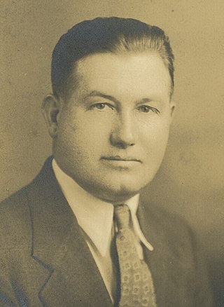
Charles Francis Keeney Jr. was a union organizer during the West Virginia Coal Wars. He served as a rank-and-file leader during the Paint Creek-Cabin Creek strike of 1912–13 and became president of United Mine Workers District 17 from his election in 1916 until 1924. He played a leadership role during the strike of 1920–21 leading up to the Battle of Blair Mountain.

The North Branch Potomac River flows from Fairfax Stone in West Virginia to its confluence with the South Branch Potomac River near Green Spring, West Virginia, where it turns into the Potomac River proper.


