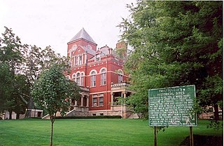
Fayette County is a county in the U.S. state of West Virginia. As of the 2010 census, the population was 46,039. Its county seat is Fayetteville. It is part of the Beckley, WV Metropolitan Statistical Area in Southern West Virginia.
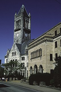
Fayette County is a county of the U.S. state of Pennsylvania. Fayette County is located in southwestern Pennsylvania, adjacent to Maryland and West Virginia. As of the 2010 census, the population was 136,606. Its county seat is Uniontown. The county was created on September 26, 1783, from part of Westmoreland County and named after the Marquis de Lafayette.
Fayette County May refer to one of several counties in the United States, each named for the Marquis de Lafayette, a Frenchman who served in the American Revolution:
Pennsylvania Route 21 is a 50.75-mile (81.67 km) long east–west state highway in the US state of Pennsylvania. The western terminus of the route is at the West Virginia state line in Richhill Township, where PA 21 continues into West Virginia as West Virginia Route 891. The eastern terminus is at U.S. Route 40 Business in Uniontown. The route is known as the Roy E. Furman Highway for most of its length. PA 21 serves Waynesburg and Masontown along the way.

Fayette is an unincorporated community in Fayette County, West Virginia, United States. Its elevation is 919 feet (280 m). It is the major take-out for the lower section of the New River Gorge National Park and Preserve.
Virginia's 17th congressional district is an obsolete congressional district. It was eliminated in 1843 after the 1840 U.S. Census. Its last Congressman was Alexander H. H. Stuart.
Belva is an unincorporated community and census-designated place in west Nicholas County and north Fayette County, West Virginia, United States; while the CDP only includes the Nicholas County portion, the Fayette County portion is considered part of the community. The town is situated at the bottomland surrounding the convergence of Bells Creek with Twentymile Creek and, subsequently, Twenty Mile Creek with the Gauley River. Belva is also the location of the convergence of two state highways: West Virginia Route 16 and West Virginia Route 39.

This is a list of the National Register of Historic Places listings in Fayette County, West Virginia.
Hopewell is an unincorporated community in Fayette County, West Virginia, United States. It lies at an elevation of 1480 feet.
Alta is an unincorporated community in Fayette County, West Virginia, United States. Alta is located on West Virginia Route 16 and West Virginia Route 39 north of Gauley Bridge.
The West Virginia Division of Juvenile Services (WVDJS) was a state agency of West Virginia, headquartered on the second floor of the Brooks Medical Building in Charleston. The agency operated juvenile correctional facilities. On July 1, 2018, the division, along with the Division of Corrections and the Regional Jail Authority, were merged into the newly created West Virginia Division of Corrections and Rehabilitation.
Midway is an unincorporated community in Fayette County, West Virginia, United States. Midway is located near the northern border of Oak Hill.
Harvey is an unincorporated community in Fayette County, West Virginia, United States. Harvey is located on County Route 25, 2.8 miles (4.5 km) south-southeast of Oak Hill.
Long Branch is an unincorporated community in Fayette County, West Virginia, United States. Long Branch is located near the West Virginia Turnpike, 1.1 miles (1.8 km) northwest of Pax. Long Branch had a post office, which closed on October 3, 1998.
Brooklyn is an unincorporated community in Fayette County, West Virginia, United States. Their post office closed in 1966.
Sunnyside was an unincorporated community and coal town in Fayette County, West Virginia, United States.

New Salem is an unincorporated community and census-designated place located in Menallen Township, Fayette County, Pennsylvania, United States. It was formerly part of the New Salem-Buffington CDP, before it was split into two separate CDPs for the 2010 census. The population of New Salem was 579 as of the 2010 census.
Hemlock is an unincorporated community in Fayette County, West Virginia, United States.


