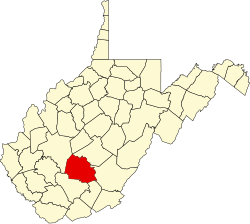
Coalfield, West Virginia

Last updated

Coalfield, West Virginia
USA West Virginia location map.svg
Red pog.svg
Coalfield
Usa edcp location map.svg
Red pog.svg
Coalfield
Coordinates: 38°00′16″N81°21′1″W / 38.00444°N 81.35028°W / 38.00444; -81.35028
Country United States
State West Virginia
County Fayette
Elevation
1,001 ft (305 m)
Time zone UTC-5 (Eastern (EST))
  Summer (DST) UTC-4 (EDT)
GNIS ID 1554165 [1]

Coalfield is an unincorporated community in Fayette County, West Virginia, United States. It was also called Krebs.

Related Research Articles

<span class="mw-page-title-main">McDowell County, West Virginia</span> County in West Virginia, United States

McDowell County is a county in the U.S. state of West Virginia. As of the 2020 census, the population was 19,111. Its county seat is Welch. McDowell County is the southernmost county in the state. It was created in 1858 by the Virginia General Assembly and named for Virginia Governor James McDowell. It became a part of West Virginia in 1863, when several Union-affiliated counties seceded from the state of Virginia during the American Civil War. McDowell County is located in the Cumberland Mountains, part of the Appalachia region.

<span class="mw-page-title-main">Northern Panhandle of West Virginia</span> Place in West Virginia, United States

The Northern Panhandle is the northern of the two panhandles in the U.S. state of West Virginia. It is a culturally and geographically distinct region of the state. It is the state's northernmost extension, bounded by Ohio and the Ohio River on the north and west and the state of Pennsylvania on the east. Its unusual configuration is the result of the Revolutionary-era claims of Virginia's former Yohogania County boundary lying along the Ohio River, conflicting with interpretations of the Colony of Pennsylvania's royal charter. The conflict was settled by compromise in the 1780s.

<span class="mw-page-title-main">U.S. Route 121</span>

U.S. Route 121 (US 121) is a proposed U.S. highway designated as the Coalfields Expressway, a four-lane highway stretching from Beckley, West Virginia, to Pound, Virginia, approximately 108 miles (174 km) in length. It is designed to connect Interstate 64 (I-64) and I-77 in West Virginia near Beckley to US 23 in Wise County, Virginia, at Pound. While US 121 will not connect directly to US 21, it will intersect at the latter road's original alignment, now a part of I-77.

<span class="mw-page-title-main">Whitby, West Virginia</span> Unincorporated community in West Virginia, United States

Whitby is an unincorporated community and coal town in the Winding Gulf Coalfield of southern West Virginia within Raleigh County, United States.

Jonben is an unincorporated community and coal town within the Winding Gulf Coalfield and is located within Raleigh County, West Virginia, United States.

<span class="mw-page-title-main">Fireco, West Virginia</span> Unincorporated community in West Virginia, United States

Fireco is an unincorporated community coal town in Raleigh County, West Virginia, United States. It lies in the Winding Gulf Coalfield of the southern part of the state. The name Fireco denotes the amount of heat the specific coal mined there could produce. This name was once a common descriptor.

The Winding Gulf Coalfield is located in western Raleigh County and eastern Wyoming County, in southern West Virginia. It is named after the Winding Gulf stream, a tributary of the Guyandotte River. In the early 20th century, it was promoted as the "Billion Dollar Coalfield".

<span class="mw-page-title-main">New River Coalfield</span>

The New River Coalfield is located in northeastern Raleigh County and southern Fayette County, West Virginia. Commercial mining of coal began in the 1870s and thrived into the 20th century. The coal in this field is a low volatile coal, known as "smokeless" coals. The seams of coal that have been mined include Sewell, Fire Creek, and Beckley. This is very high quality bituminous coal rated at approximately 15,000 BTU (16,000 kJ). The New River coalfield is named after the north flowing New River. Over 60 coal towns were once located there, supported by independent commercial districts at Beckley, Oak Hill, Mount Hope, and Fayetteville. By the 21st century many coal camps had partially or completely returned to nature. These company towns were located along Dunloup (Loup) Creek, Laurel Creek, White Oak Creek, lower Piney Creek, and, of course, the New River. The mainline of the Chesapeake and Ohio Railway ran right through the center of this coalfield, with spurs branching off in many directions, and rail yards were maintained at Quinnimont, Raleigh, and Thurmond, WV. The Virginian Railway's main line also passed through the western side of the field as well. Companies such as the New River Company, New River & Pocahontas Consolidated Coal Co., and Mary Frances Coal Co. were the largest operators in the New River Coalfield, but there were many smaller ones as well. These companies recruited native born whites, immigrants from Southern and Eastern Europe, and African-Americans from the South to work in their coal mines and railroads. The mines began to close down after World War II and today there are very few active coal mines in the field. The New River Gorge is now the domain of the National Park Service as the New River Gorge National Park and Preserve, and they have done what their budget allows to preserve the coal heritage of the area.

<span class="mw-page-title-main">Southwest Virginia</span> Mountainous region of Virginia in the westernmost part of the commonwealth

Southwest Virginia, often abbreviated as SWVA, is a mountainous region of Virginia in the westernmost part of the commonwealth. Located within the broader region of western Virginia, Southwest Virginia has been defined alternatively as all Virginia counties on the Appalachian Plateau, all Virginia counties west of the Eastern Continental Divide, or at its greatest expanse, as far east as Blacksburg and Roanoke. Another geographic categorization of the region places it as those counties within the Tennessee River watershed. Regardless of how borders are drawn, Southwest Virginia differs from the rest of the commonwealth in that its culture is more closely associated with Appalachia than the other regions of Virginia. Historically, the region has been and remains a rural area, but in the 20th century, coal mining became an important part of its economy. With the decline in the number of coal jobs and the decline of tobacco as a cash crop, Southwest Virginia is increasingly turning to tourism as a source of economic development. Collectively, Southwest Virginia's craft, music, agritourism and outdoor recreation are referred to as the region's "creative economy."

<span class="mw-page-title-main">Pocahontas Coalfield</span>

Pocahontas Coalfield, which is also known as the Flat Top-Pocahontas Coalfield, is located in Mercer County/McDowell County, West Virginia and Tazewell County, Virginia. The earliest mining of coal in the coalfield was in Pocahontas, Virginia in 1883 at Pocahontas Mine No. 1, now on the National Register of Historic Places.

The Logan Coalfield is a coalfield located in Logan County and Wyoming County of southern West Virginia, in the Appalachia region of the eastern United States.

Big Stick was an unincorporated community in Raleigh County, West Virginia, United States. It lies along County Route 3/2, beside Winding Gulf. This community is part of the Winding Gulf Coalfield in Raleigh County.

<span class="mw-page-title-main">Hot Coal, West Virginia</span> Unincorporated community in West Virginia, United States

Hot Coal or Hotcoal was an unincorporated community and coal town located along the Winding Gulf Creek in Raleigh County, West Virginia, United States. Originally, it was named Patterson and later acquired the name Hot Coal. It was the next community past Big Stick on County Route 3/2. Although, the community now no longer exists, the Winding Gulf Bank, now the National Bank at Beckley, resided at Hot Coal and was moved to Beckley on January 1, 1914. Hot Coal at one time had a Post Office

<span class="mw-page-title-main">National Register of Historic Places listings in McDowell County, West Virginia</span>

This is a list of the National Register of Historic Places listings in McDowell County, West Virginia.

Abney is an unincorporated community in Raleigh County, West Virginia, United States. Abney is 3 miles (4.8 km) southeast of Sophia. Abney was once known as Phillips.

Whipple is an unincorporated community in Fayette County, West Virginia, United States. Whipple is located on West Virginia Route 612, 1.5 miles (2.4 km) southwest of Oak Hill.

<span class="mw-page-title-main">Battleship, West Virginia</span> Unincorporated community in West Virginia, United States

Battleship is an unincorporated community located in Raleigh County, West Virginia, United States. Battleship has been known by two other names: Ralco and West Whitby. The community was part of the Winding Gulf Coalfield.

Coal Valley is an unincorporated community in Logan County, West Virginia, United States.

<span class="mw-page-title-main">Elverton, West Virginia</span> Unincorporated community in West Virginia, United States

Elverton is an unincorporated community and coal town in Fayette County, West Virginia, United States.

References