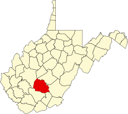
Garten, West Virginia

Last updated
Garten, West Virginia
USA West Virginia location map.svg
Red pog.svg
Garten
Usa edcp location map.svg
Red pog.svg
Garten
Coordinates: 38°2′4″N81°4′36″W / 38.03444°N 81.07667°W / 38.03444; -81.07667 Coordinates: 38°2′4″N81°4′36″W / 38.03444°N 81.07667°W / 38.03444; -81.07667
CountryUnited States
State West Virginia
County Fayette
Area
[1]
  Total0.42 sq mi (1.09 km2)
  Land0.42 sq mi (1.09 km2)
  Water0.0 sq mi (0.0 km2)
Elevation
1,980 ft (600 m)
Population
 (2020) [2]
204
Time zone UTC-5 (Eastern (EST))
  Summer (DST) UTC-4 (EDT)
ZIP Code
25840 (Fayetteville)
Area code(s) 304/681
FIPS code 54-30148
GNIS feature ID2807481 [3]

Garten is an unincorporated community and census-designated place (CDP) in Fayette County, West Virginia, United States. As of the 2020 census, it had a population of 204. [2]

Garten is in the center of the county, 2.5 miles (4.0 km) southeast of Fayetteville, the county seat, and 9 miles (14 km) northeast of Oak Hill. It is about 1 mile (1.6 km) southwest of the west rim of the New River Gorge.

Related Research Articles

Accoville is an unincorporated community and census-designated place (CDP) in Logan County, West Virginia, United States. The community lies along Buffalo Creek. As of the 2010 United States Census, its population was 574.

McConnell is an unincorporated community and census-designated place (CDP) in Logan County, West Virginia, United States, on the Guyandotte River. As of the 2010 census, its population was 514. It was established in 1933.

Sarah Ann is a census-designated place (CDP) in Logan County, West Virginia, United States. The CDP includes the unincorporated community of Sarah Ann, plus the neighboring communities of Crystal Block and part of Stirrat. As of the 2010 census, the population of the CDP was 345.

<span class="mw-page-title-main">Kistler, West Virginia</span> Census-designated place in West Virginia, United States

Kistler is an unincorporated community and census-designated place (CDP) in Logan County, West Virginia, United States. As of the 2010 census, its population was 528.

Greenville is an unincorporated community and census-designated place (CDP) in Logan County, West Virginia, United States. It was first listed as a CDP prior to the 2020 census.

Stollings is an unincorporated community and census-designated place (CDP) in central Logan County, West Virginia, United States. As of the 2010 census, it had a population of 316.

Robinette is an unincorporated community and census-designated place (CDP) in Logan County, West Virginia, United States, along Buffalo Creek. Its population was 663 as of the 2010 census. Prior to 2010, Robinette was part of the Amherstdale-Robinette CDP.

<span class="mw-page-title-main">Amherstdale, West Virginia</span> Census-designated place in West Virginia, United States

Amherstdale is a census-designated place (CDP) in Logan County, West Virginia, United States, situated along Buffalo Creek. The CDP includes the unincorporated communities of Amherstdale, Becco, Fanco, and Braeholm. The CDP population was 350 as of the 2010 census.

<span class="mw-page-title-main">Moorefield, Virginia</span> Census-designated place in Virginia

Moorefield is a census-designated place (CDP) in Loudoun County, Virginia, United States. As of the 2010 census, the CDP was named Moorefield Station, and the population was 77. As of 2019, the estimated population was 1,976. Moorefield is a mixed-use development currently in progress, located at the Ashburn station currently under construction at the planned terminus of the Metrorail Silver Line.

<span class="mw-page-title-main">Neibert, West Virginia</span> Census-designated place in West Virginia, United States

Neibert is an unincorporated community and census-designated place (CDP) in Logan County, West Virginia, United States. Its population was 183 as of the 2010 census.

Rossmore is an unincorporated community and census-designated place (CDP) in Logan County, West Virginia, United States, along West Virginia Route 44 and Island Creek. Its population was 301 as of the 2010 census.

Crooked Creek is an unincorporated community and census-designated place (CDP) in Logan County, West Virginia, United States. The CDP was first drawn for the 2020 census.

Justice Addition is an unincorporated community and census-designated place (CDP) in Logan County, West Virginia, United States. The community was first listed as a CDP prior to the 2020 census. The population was 331 at the 2020 census.

Goose Creek Village is a census-designated place (CDP) in Loudoun County, Virginia, United States. It was first drawn as a CDP prior to the 2020 census.

Schooner Bay is a census-designated place (CDP) in Accomack County, Virginia, United States. As of the 2020 census, it had a population of 97.

Stewartsville is an unincorporated community and census-designated place (CDP) in Bedford County, Virginia, United States. As of the 2020 census, it had a population of 533.

Mechanicsburg is an unincorporated community and census-designated place (CDP) in Bland County, Virginia, United States. As of the 2020 census, it had a population of 81.

Hilltown is an unincorporated community and census-designated place (CDP) in Grayson and Carroll counties, Virginia, United States. As of the 2020 census, it had a population of 216.

Innovation is an unincorporated area and census-designated place (CDP) in Prince William County, Virginia, United States. As of the 2020 census, it had a population of 926.

West Dunbar is an unincorporated community and census-designated place (CDP) in Kanawha County, West Virginia, United States. As of the 2020 census, it had a population of 617.

References

  1. "2020 U.S. Gazetteer Files – West Virginia". United States Census Bureau. Retrieved October 26, 2021.
  2. 1 2 "Garten CDP, West Virginia: 2020 DEC Redistricting Data (PL 94-171)". U.S. Census Bureau. Retrieved October 26, 2021.
  3. "Garten Census Designated Place". Geographic Names Information System . United States Geological Survey, United States Department of the Interior.