Gaymont, West Virginia

Last updated
Gaymont, West Virginia
USA West Virginia location map.svg
Red pog.svg
Gaymont
Usa edcp location map.svg
Red pog.svg
Gaymont
Coordinates: 38°6′53″N81°5′47″W / 38.11472°N 81.09639°W / 38.11472; -81.09639 Coordinates: 38°6′53″N81°5′47″W / 38.11472°N 81.09639°W / 38.11472; -81.09639
Country United States
State West Virginia
County Fayette
Elevation
1,470 ft (450 m)
Time zone UTC-5 (Eastern (EST))
  Summer (DST) UTC-4 (EDT)
GNIS ID 1554544 [1]

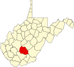
Gaymont or Camont is an unincorporated community and coal town in Fayette County, West Virginia, United States.

Related Research Articles

Ohio River Major river in the midwestern United States

The Ohio River is a 981-mile (1,579 km) long river in the United States. It is located in the Midwestern and Southern United States, flowing southwesterly from western Pennsylvania south of Lake Erie to its mouth on the Mississippi River at the southern tip of Illinois. It is the third largest river by discharge volume in the United States and the largest tributary by volume of the north-south flowing Mississippi River that divides the eastern from western United States. The river flows through or along the border of six states, and its drainage basin includes parts of 14 states. Through its largest tributary, the Tennessee River, the basin includes several states of the southeastern U.S. It is the source of drinking water for three million people.

Palestine Disambiguation page providing links to topics that could be referred to by the same search term

Palestine may refer to:

West Virginia State of the United States of America

West Virginia is a state in the Appalachian, Mid-Atlantic and Southeastern regions of the United States. It is bordered by Pennsylvania to the northeast, Maryland to the east and northeast, Virginia to the southeast, Kentucky to the southwest, and Ohio to the northwest. West Virginia is the 41st-largest state by area and ranks 38th in population, with a population of 1,795,045 residents. The capital and largest city is Charleston.

Charleston, West Virginia Capital of West Virginia

Charleston is the capital and most populous city of the U.S. state of West Virginia. Located at the confluence of the Elk and Kanawha rivers, the city had a population of 51,400 at the 2010 census and an estimated population of 46,536 in 2019. The Charleston metropolitan area as a whole had an estimated 208,089 residents in 2019. Charleston is the center of government, commerce, and industry for Kanawha County, of which it is the county seat.

Morgantown, West Virginia City in West Virginia, United States

Morgantown is the county seat of Monongalia County, West Virginia, United States, situated along the Monongahela River. West Virginia University is located in the city. The population was 29,660 at the 2010 Census Bureau, making Morgantown the largest city in North-Central West Virginia. The Morgantown metropolitan area has a population of 138,176.

Wheeling, West Virginia City in West Virginia, United States

Wheeling is a city in Ohio and Marshall counties in the U.S. state of West Virginia. Located almost entirely in Ohio County, of which it is the county seat, it lies along the Ohio River in the foothills of the Appalachian Mountains. Wheeling was originally a settlement in the British colony of Virginia, and later the second largest city in the Commonwealth of Virginia. Wheeling was where creation of West Virginia was planned, and it was the first capital of the new state. Due to its location along major transportation routes, including the Ohio River, National Road, and the B&O Railroad, Wheeling became a manufacturing center in the late nineteenth century. After experiencing the closing of factories and substantial population loss following World War II, Wheeling's major industries now include healthcare, education, law and legal services, entertainment and tourism, and energy.

West Virginia University Public university in West Virginia, U.S.

West Virginia University (WVU) is a public, land-grant, research university with its main campus in Morgantown, West Virginia. Its other campuses are those of the West Virginia University Institute of Technology in Beckley, Potomac State College of West Virginia University in Keyser, and a second clinical campus for the university's medical and dental schools at Charleston Area Medical Center in Charleston. WVU Extension Service provides outreach with offices in all of West Virginia's 55 counties.

Take Me Home, Country Roads 1971 single by John Denver

"Take Me Home, Country Roads", also known simply as "Take Me Home" or "Country Roads", is a song written by Bill Danoff, Taffy Nivert and John Denver about West Virginia. It was released as a single performed by Denver on April 12, 1971, peaking at number two on Billboard's US Hot 100 singles for the week ending August 28, 1971. The song was a success on its initial release and was certified Gold by the RIAA on August 18, 1971, and Platinum on April 10, 2017. The song became one of John Denver's most popular and beloved songs. It has continued to sell, with over 1.6 million digital copies sold in the United States.

Aurora, West Virginia Census-designated place in West Virginia, United States

Aurora is a census-designated place (CDP) in Preston County, West Virginia, United States. As of the 2010 census, its population was 201. Aurora was originally a German settlement. The town was originally called Salem and later Mount Carmel. Its current name was suggested because of the town's high altitude. One of the original settlers to the area was John Stough, a Lutheran minister. The primary industries throughout the early and mid-19th century were farming and timber. In the late 1880s the town became known as a resort area thanks to several large hotels which were built in the area. Some of these featured casinos, pools, and concert halls. In the 1930s an artist colony formed in the nearby Youghiogheny Forest area. Aurora is located on U.S. Route 50 between the Maryland state line and the town of Rowlesburg. Cathedral State Park is located to the east of Aurora's post office.
National Register of Historic Places listings in West Virginia

This is a list of properties and historic districts in West Virginia that are listed on the National Register of Historic Places. There are listings in every one of West Virginia's 55 counties.

West Virginia in the American Civil War Origin of West Virginia; during the U.S. Civil War

The U.S. state of West Virginia was formed out of western Virginia and added to the Union as a direct result of the American Civil War, in which it became the only modern state to have declared its independence from the Confederacy. In the summer of 1861, Union troops, which included a number of newly-formed Western Virginia regiments, under General George McClellan, drove off Confederate troops under General Robert E. Lee. This essentially freed Unionists in the northwestern counties of Virginia to form a functioning government of their own as a result of the Wheeling Convention. Prior to the admission of West Virginia the government in Wheeling formally claimed jurisdiction over all of Virginia, although from its creation it was firmly committed to the formation of a separate state.

West Virginia Mountaineers football American college football team

The West Virginia Mountaineers football team represents West Virginia University in the NCAA Football Bowl Subdivision (FBS) of college football. West Virginia plays its home games on Mountaineer Field at Milan Puskar Stadium on the campus of West Virginia University in Morgantown, West Virginia. The Mountaineers have won or shared a total of 15 conference championships, including eight Southern Conference titles and seven Big East Conference titles. The Mountaineers compete in the Big 12 Conference and are led by head coach Neal Brown.

The Huntington–Ashland metropolitan area is a metropolitan area in the Appalachian Plateau region of the United States. Referred to locally as the “Tri-State area”, the region spans seven counties in the three states of West Virginia, Kentucky, and Ohio. With a population of 361,580, the Tri-State area is nestled along the banks of the Ohio River. The region offers a diverse range of outdoor activities.

Gay Mont United States historic place

Gaymont, or Gay Mont, is a historic home located at Port Royal, Caroline County, Virginia. Originally called "Rose Hill", the central section of the house was built about 1790 by John Hipkins as a two-story frame structure with a gable roof and two exterior end chimneys. His grandson and heir, John Hipkins Bernard, renamed the house in honor of his wife, Jane Gay Bolling Robertson, a descendant of Pocahontas. It was enlarged in 1819 with the addition of flanking one-story stuccoed brick wings and a one-story colonnade of stuccoed brick Tuscan columns. In 1834 a one-story octagonal music room was added and in 1839 an octagonal library and office at the ends of each wing. Except for a brief 18-month change in ownership in 1958–1959, the house remained in the Bernard-Robb family until 2007 at which time it transferred to the Association for the Preservation of Virginia Antiquities. A family cemetery with almost 40 graves is set just to the north of the house along the forest edge.

Stephen A. Gaymont was a Hungarian bacteriologist who was one of the pioneers in the United States yogurt market.

COVID-19 pandemic in West Virginia COVID-19 pandemic in West Virginia, United States

The U.S. state of West Virginia reported its first confirmed case relating to the COVID-19 pandemic on March 17, 2020, becoming the last state to do so. However, the particular patient had been showing symptoms for several days prior. On March 29, 2020, the state reported its first COVID-19 death.

References