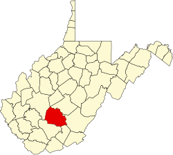
Mossy, West Virginia | |
---|---|
Coordinates: 37°58′34″N81°16′54″W / 37.97611°N 81.28167°W | |
Country | United States |
State | West Virginia |
County | Fayette |
Elevation | 1,417 ft (432 m) |
Time zone | UTC-5 (Eastern (EST)) |
• Summer (DST) | UTC-4 (EDT) |
Area code(s) | 304 & 681 |
GNIS feature ID | 1543600 [1] |
Mossy is an unincorporated community in Fayette County, West Virginia, United States. Mossy is located off exit 60 on the West Virginia Turnpike and is west of Oak Hill. As of 1993, the community had an Exxon gas station, and motel, all owned by Teddy Gray. [2] The motel has burned down and is gone.
A motel, also known as a motor hotel, motor inn or motor lodge, is a hotel designed for motorists, usually having each room entered directly from the parking area for motor vehicles rather than through a central lobby. Entering dictionaries after World War II, the word motel, coined as a portmanteau of "motor hotel", originates from the defunct motel named Milestone Mo-Tel in San Luis Obispo, California, which was built in 1925. The term referred to a type of hotel consisting of a single building of connected rooms whose doors faced a parking lot and in some circumstances, a common area or a series of small cabins with common parking. Motels are often individually owned, though motel chains do exist.
Centreville, Centerville, Centre-ville or Centre-Ville and variants may refer to:
Walton County is a county located on the Emerald Coast in the northwestern part of the U.S. state of Florida, with its southern border on the Gulf of Mexico. As of the 2020 census, the population was 75,305. Its county seat is DeFuniak Springs. The county is home to the highest natural point in Florida: Britton Hill, at 345 feet (105 m). Walton County is included in the Crestview–Fort Walton Beach–Destin Metropolitan Statistical Area.
Pendleton County is a county located in the U.S. state of West Virginia. As of the 2020 census, the population was 6,143, making it the second-least populous county in West Virginia. Its county seat is Franklin. The county was created by the Virginia General Assembly in 1788 from parts of Augusta, Hardy, and Rockingham counties and was named for Edmund Pendleton (1721–1803), a distinguished Virginia statesman and jurist. Pendleton County was strongly pro-Confederate during the American Civil War; however, there were pockets of Unionists who supported the state government in Wheeling.
Fayette County is a county in the U.S. state of West Virginia. As of the 2020 census, the population was 40,488. Its county seat is Fayetteville. It is part of the Beckley, WV Metropolitan Statistical Area in Southern West Virginia.
Jefferson City is a city in Jefferson County, Tennessee, United States. It is part of the Morristown Metropolitan Statistical Area. As of the 2020 census the population was 8,419.
Amboy is an unincorporated community in San Bernardino County, in California's Mojave Desert, west of Needles and east of Ludlow on historic Route 66. It is roughly 60 miles (97 km) northeast of Twentynine Palms. As of 2020, the town's business district still contained a post office, a historic restaurant-motel, and a Route 66 tourist shop, all operated by the town's population of four people. As of 2024, only the gas station was open, and the population was zero.
West Virginia Route 612 is an east–west state highway in Fayette County, West Virginia. The western terminus of the route is at Interstate 64 and Interstate 77 southeast of Mossy. The eastern terminus is at U.S. Route 19 south of Oak Hill.
Big Run is a 4.4-mile-long (7.1 km) tributary stream of the South Branch Potomac River, belonging to the Potomac River and Chesapeake Bay watersheds. Big Run flows through the city of Romney and the campus of the West Virginia Schools for the Deaf and Blind in Hampshire County, West Virginia. The stream is known by local residents as Town Run and Town Creek.
Interstate 77 (I-77) in the US state of West Virginia is a major north–south Interstate Highway. It extends for 187.21 miles (301.29 km) between Bluefield at the Virginia state line and Williamstown at the Ohio state line.
Zion Crossroads is an unincorporated community in Louisa and Fluvanna counties of Virginia. It is at the intersections of James Madison Highway and Three Notch Road. Interstate 64 in Virginia passes one-half mile to the northeast.
The Virginia Park Historic District is located on the north side of New Center, an area in Detroit, Michigan, along both sides of Virginia Park Street from Woodward Avenue to the John C. Lodge Freeway access road. The district was listed on the National Register of Historic Places in 1982.
Plum Orchard Lake Wildlife Management Area, is located near Pax, West Virginia in Fayette county. Located on 3,201 acres (1,295 ha) land that varies from wetlands to steeply forested woodlands, the Pleasant Creek WMA rises to an elevation of 1,600 feet (490 m).
Silver Lake is an unincorporated community in Preston County, West Virginia, United States. Silver Lake is located along U.S. Route 219, 7.5 miles (12.1 km) north of Thomas in Tucker County.
Mossy may refer to:
Mossy Creek is an unincorporated community in Augusta County, Virginia, United States. Mossy Creek is located on Virginia State Route 42 3.3 miles (5.3 km) west-southwest of Bridgewater. The Hannah Miller House and the Henry Miller House, which are listed on the National Register of Historic Places, are both located near Mossy Creek.
Paint Creek is a 42.1-mile (67.8 km) tributary of the Kanawha River in southern West Virginia. Paint Creek is part of the Mississippi River watershed via the Kanawha and Ohio Rivers and drains an area of 123 square miles (320 km2).
The 2016 Cactus Bowl was a post-season American college football bowl game played on January 2, 2016 at Chase Field in Phoenix, Arizona. This was the twenty-seventh edition of the Cactus Bowl, although only the second played under that name. Sponsored by the Motel 6 chain of budget motels, the game was officially known as the Motel 6 Cactus Bowl.
Mossy Creek may refer to: