Columbia, West Virginia

Last updated

Columbia, West Virginia
USA West Virginia location map.svg
Red pog.svg
Columbia
Usa edcp location map.svg
Red pog.svg
Columbia
Coordinates: 38°7′22″N81°18′39″W / 38.12278°N 81.31083°W / 38.12278; -81.31083
Country United States
State West Virginia
County Fayette
Elevation
728 ft (222 m)
Time zone UTC-5 (Eastern (EST))
  Summer (DST) UTC-4 (EDT)
GNIS ID 1537540 [1]

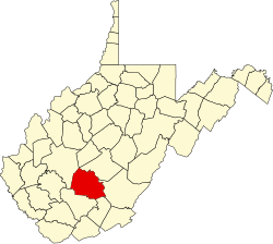
Columbia is an unincorporated community in Fayette County, West Virginia, United States, situated along Armstrong Creek. [2]

Related Research Articles

<span class="mw-page-title-main">Interstate 77</span> Interstate Highway from South Carolina to Ohio

Interstate 77 (I-77) is a north–south Interstate Highway in the eastern United States. It traverses diverse terrain, from the mountainous state of West Virginia to the rolling farmlands of North Carolina and Ohio. It largely supplants the old US Route 21 (US 21) between Cleveland, Ohio, and Columbia, South Carolina, as an important north–south corridor through the middle Appalachians. The southern terminus of I-77 is in Cayce, South Carolina, in Lexington County at the junction with I-26. The northern terminus is in Cleveland at the junction with I-90. Other major cities that I-77 connects to include Columbia, South Carolina; Charlotte, North Carolina; Charleston, West Virginia; and Akron, Ohio. The East River Mountain Tunnel, connecting Virginia and West Virginia, is one of only two instances in the United States where a mountain road tunnel crosses a state line. The other is the Cumberland Gap Tunnel, connecting Tennessee and Kentucky. I-77 is a snowbird route to the Southern United States for those traveling from the Great Lakes region.

<span class="mw-page-title-main">Washington–Baltimore combined statistical area</span> CSA in the United States

The Washington–Baltimore combined statistical area is a statistical area including two overlapping metropolitan areas, Washington, D.C., and Baltimore, Maryland. The region includes Central Maryland, Northern Virginia, three counties in the Eastern Panhandle of West Virginia, and one county in South Central Pennsylvania. It is the most educated, highest-income, and third-largest combined statistical area in the United States behind New York–Newark and Los Angeles–Long Beach.

<span class="mw-page-title-main">U.S. Route 21</span> Highway in the United States

U.S. Route 21 or U.S. Highway 21 (US 21) is a major north–south United States Numbered Highway in the Southeastern United States that travels 394 miles (634 km). The southern terminus is in Hunting Island State Park, South Carolina, 14.4 miles (23.2 km) south of the junction with US 21 Business and South Carolina Highway 802 (SC 802) in Beaufort. The northern terminus is in Wytheville, Virginia at an interchange with Interstate 81 (I-81) and US 52. Despite the "1" indicating that it is a major north-south highway, U.S. 21 only travels through three states, and is no longer a cross-country route as it has been replaced with Interstate 77 in both Ohio and West Virginia. It also has the second-shortest length of all of the major north-south routes, just behind U.S. 91. The route travels through the states of South Carolina, North Carolina, and Virginia. It also connects through major Southeastern cities such as Columbia, South Carolina and Charlotte, North Carolina. The northern portion of the road travels parallel to I-77 in northern South Carolina and North Carolina. The road also has three interchanges with I-26 in Lexington and Calhoun counties in South Carolina.

<span class="mw-page-title-main">South Atlantic states</span> U.S. census division

The South Atlantic United states form one of the nine Census Bureau Divisions within the United States that are recognized by the United States Census Bureau. This region, U.S. Census Bureau Region 3, Division 5, corresponds to the South with the addition of Florida.

<span class="mw-page-title-main">United States National Register of Historic Places listings</span> Register for landmarks in the United States

The National Register of Historic Places in the United States is a register including buildings, sites, structures, districts, and objects. The Register automatically includes all National Historic Landmarks as well as all historic areas administered by the U.S. National Park Service. Since its introduction in 1966, more than 90,000 separate listings have been added to the register.

Columbia blue is a light blue color named after Columbia University. The color itself derives from the official hue of the Philolexian Society, the university's oldest student organization. Although Columbia blue is often identified with Pantone 292, the Philolexian Society first used it in the early 19th century, before the standardization of colors. Pantone 290, a slightly lighter shade of blue, has also been specified by some Columbia University offices, and is the current official color listed by the Columbia University visual communications office. Several other shades are also used by parts of the university in an official capacity.

<span class="mw-page-title-main">National Register of Historic Places listings in Virginia</span>

Buildings, sites, districts, and objects in Virginia listed on the National Register of Historic Places:

<span class="mw-page-title-main">1810 United States census</span> The third U.S. national census increased by 36.4% since the 1800 census.

The United States census of 1810 was the third census conducted in the United States. It was conducted on August 6, 1810. It showed that 7,239,881 people were living in the United States, of whom 1,191,362 were slaves.

<span class="mw-page-title-main">1830 United States census</span> Fifth US census

The United States census of 1830, the fifth census undertaken in the United States, was conducted on June 1, 1830. The only loss of census records for 1830 involved some countywide losses in Massachusetts, Maryland, and Mississippi.

<span class="mw-page-title-main">Boundary markers of the original District of Columbia</span> Markers that marked the District of Columbias original boundary

The boundary markers of the original District of Columbia are the 40 milestones that marked the four lines forming the boundaries between the states of Maryland and Virginia and the square of 100 square miles (259 km2) of federal territory that became the District of Columbia in 1801. Working under the supervision of three commissioners that President George Washington had appointed in 1790 in accordance with the federal Residence Act, a surveying team that Major Andrew Ellicott led placed these markers in 1791 and 1792. Among Ellicott's assistants were his brothers Joseph and Benjamin Ellicott, Isaac Roberdeau, George Fenwick, Isaac Briggs and an African American astronomer, Benjamin Banneker.

<span class="mw-page-title-main">Stuart F. Reed</span> American politician

Stuart Felix Reed was an American lawyer and Republican politician who became the Secretary of State of West Virginia (1909–1917) and represented West Virginia's 3rd congressional district in the United States House of Representatives (1917–1925).

The following radio stations broadcast on FM frequency 100.1 MHz:

West Columbia is an unincorporated community in Mason County, West Virginia, United States. West Columbia is located on the Ohio River and West Virginia Route 62, 3 miles (4.8 km) southwest of Mason. West Columbia has a post office with ZIP code 25287.

<span class="mw-page-title-main">Patrick Morrisey</span> American politician (born 1967)

Patrick James Morrisey is an American politician and attorney serving as the 34th Attorney General of West Virginia since 2013. He is a member of the Republican Party.

<span class="mw-page-title-main">1980 United States presidential election in West Virginia</span> Election in West Virginia

The 1980 United States presidential election in West Virginia took place on November 4, 1980, in West Virginia as part of the 1980 United States presidential election.

References