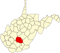
Glade, West Virginia

Last updated
Glade, West Virginia
USA West Virginia location map.svg
Red pog.svg
Glade
Usa edcp location map.svg
Red pog.svg
Glade
Coordinates: 37°49′56″N81°00′3″W / 37.83222°N 81.00083°W / 37.83222; -81.00083 Coordinates: 37°49′56″N81°00′3″W / 37.83222°N 81.00083°W / 37.83222; -81.00083
Country United States
State West Virginia
County Fayette
Elevation
1,243 ft (379 m)
Time zone UTC-5 (Eastern (EST))
  Summer (DST) UTC-4 (EDT)
GNIS ID 1554559 [1]

Glade is an unincorporated community in Fayette County, West Virginia, United States. It was also known as Paw Paw.

The community takes its name from nearby Glade Creek. [2]

Related Research Articles

Glades County, Florida County in Florida, United States

Glades County is a county located in the U.S. state of Florida. As of the 2010 census, the population was 12,884, making it the fourth-least populous county in Florida. Its county seat is Moore Haven.

Glade Spring, Virginia Town in Virginia, United States

Glade Spring is a town in Washington County, Virginia, United States. The population was 1,456 at the 2010 census. It is part of the Kingsport–Bristol (TN)–Bristol (VA) Metropolitan Statistical Area, which is a component of the Johnson City–Kingsport–Bristol, TN-VA Combined Statistical Area – commonly known as the "Tri-Cities" region.

Paw Paw, West Virginia Town in West Virginia, United States

Paw Paw is a town in Morgan County, West Virginia, United States. The population was 508 in the 2010 census. The town is known for the nearby Paw Paw Tunnel. Paw Paw was incorporated by the Circuit Court of Morgan County on April 8, 1891 and named for the pawpaw, a wild fruit which grows in abundance throughout this region. Paw Paw is the westernmost incorporated community in Morgan County and the Hagerstown-Martinsburg, MD-WV Metropolitan Statistical Area.

Okonoko, West Virginia Unincorporated community in West Virginia, United States

Okonoko is an unincorporated community in Hampshire County in the U.S. state of West Virginia. Okonoko is located north of Levels on the Potomac River at Bright's Hollow. The community's placename is the only one of its kind within the United States.

Cranberry Glades

Cranberry Glades — also known simply as The Glades — are a cluster of five small, boreal-type bogs in southwestern Pocahontas County, West Virginia, United States. This area, high in the Allegheny Mountains at about 3,400 feet (1,000 m), is protected as the Cranberry Glades Botanical Area, part of the Monongahela National Forest. This site is the headwaters of the Cranberry River, a popular trout stream, and is adjacent to the nearly 50,000-acre (200 km2) Cranberry Wilderness.

West Virginia Route 29 is a north–south state highway located in the Eastern Panhandle of West Virginia. The southern terminus of the route is at West Virginia Route 55 and West Virginia Route 259 in Baker, Hardy County. The northern terminus is at West Virginia Route 9 three miles (5 km) south of Paw Paw in Hampshire County.

Magnolia, West Virginia Unincorporated community in West Virginia, United States

Magnolia is an unincorporated community northeast of Paw Paw in Morgan County in the U.S. state of West Virginia on the Potomac River. Magnolia is located along the Baltimore and Ohio Railroad mainline and east of where the Western Maryland Railway crosses the Potomac, bypassing a series of bends in the river. As a depot and water station on the B&O, Magnolia has been known by a number of names including Magnolia Dale, Magnolia Vale, and sometimes as Water Station Number 12 on the railroad.

Jerome, West Virginia Unincorporated community in West Virginia, United States

Jerome is an uninhabited community along the old Baltimore and Ohio Railroad main line in Morgan County in the U.S. state of West Virginia. It is located entirely within the Chesapeake and Ohio Canal National Historical Park on the Potomac River. Jerome is also the site of a stretch of the Western Maryland Railway right-of-way from milepost 126 to milepost 160 listed on the National Register of Historic Places. Located in the "Paw Paw Bends", Jerome was considered to be one of the most inaccessible places reached by the Western Maryland Rwy.

Woodrow, Hampshire and Morgan Counties, West Virginia Unincorporated community in West Virginia, United States

Woodrow is an unincorporated community that lies south of Paw Paw along West Virginia Route 9 in both Hampshire and Morgan Counties in West Virginia's Eastern Panhandle. Woodrow lies on the eastern flanks of Spring Gap Mountain with Sideling Hill to its east. Woodrow Union Church has served the community since the late 19th century.

Calcareous glade Calcareous glades occur where bedrock such as limestone occurs near or at the surface, and have very shallow and little soil development.

A calcareous glade is a type of ecological community that is found in the central eastern United States. Calcareous glades occur where bedrock such as limestone occurs near or at the surface, and have very shallow and little soil development. Because of the shallow soil and the extreme conditions created by it, trees are often unable to grow in the glades. This creates a habitat that is usually sunny, dry, and hot. Calcareous glade vegetation is more similar to that of a desert habitat than a grassland, being dominated by small spring annuals with occasional geophytic or succulent perennials.

Grays Flat, West Virginia Unincorporated community in West Virginia, United States

Grays Flat is an unincorporated community in Marion County, West Virginia, United States. It lies along the Paw Paw Creek, adjacent on the northeast of Grant Town.

Mountview, West Virginia Unincorporated community in West Virginia, United States

Mountview is an unincorporated community in Raleigh and Summers counties, West Virginia, United States. Mountview is west of Hinton and southeast of Beckley. County Routes 3/1, 3/12, and 19/22 are in Mountview. There are two ponds: one near Mt. View Road and another near Country Route 3/12. Spicelick Creek, Glade Creek, and Farley Creek run through the town. Features close to Mountview are Lake View Golf Course and the artificial Flat Top Lake.

Glady, West Virginia Unincorporated community in West Virginia, United States

Glady is an unincorporated community in Randolph County, West Virginia, United States. Glady is 11 miles (18 km) southeast of Elkins. Glady had a post office, which closed on May 14, 2011.

Wadestown, West Virginia Unincorporated community in West Virginia, United States

Wadestown — formerly West Warren — is an unincorporated community in Monongalia County, West Virginia, United States. It is located on West Virginia Route 7, approximately 7.5 miles (12.1 km) west-southwest of Blacksville.

Glade Farms, West Virginia Unincorporated community in West Virginia, United States

Glade Farms is an unincorporated community in Preston County, West Virginia, United States. Glade Farms is located on West Virginia Route 26 6 miles (9.7 km) north-northeast of Brandonville.

Glade Springs, West Virginia is an unincorporated community consisting of a gated community and resort located just outside Beckley in Raleigh County, West Virginia.

Paw Paw, Marion County, West Virginia Unincorporated community in West Virginia, United States

Paw Paw is an unincorporated community in Marion County, West Virginia, United States.

Gladesville is an unincorporated community in Preston County, in the U.S. state of West Virginia.

References

  1. U.S. Geological Survey Geographic Names Information System: Glade, West Virginia
  2. Kenny, Hamill (1945). West Virginia Place Names: Their Origin and Meaning, Including the Nomenclature of the Streams and Mountains. Piedmont, WV: The Place Name Press. p. 270.