Edmond, West Virginia

Last updated

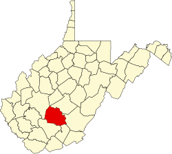
Edmond is an unincorporated community in Fayette County, in the U.S. state of West Virginia. [1]

Fayette County, West Virginia County in the United States

Fayette County is a county in the U.S. state of West Virginia. As of the 2010 census, the population was 46,039. Its county seat is Fayetteville. It is part of the Beckley, WV Metropolitan Statistical Area in Southern West Virginia.

U.S. state constituent political entity of the United States

In the United States, a state is a constituent political entity, of which there are currently 50. Bound together in a political union, each state holds governmental jurisdiction over a separate and defined geographic territory and shares its sovereignty with the federal government. Due to this shared sovereignty, Americans are citizens both of the federal republic and of the state in which they reside. State citizenship and residency are flexible, and no government approval is required to move between states, except for persons restricted by certain types of court orders. Four states use the term commonwealth rather than state in their full official names.

West Virginia State of the United States of America

West Virginia is a state located in the Appalachian region in the Southern United States and is also considered to be a part of the Middle Atlantic States. It is bordered by Pennsylvania to the north, Maryland to the east and northeast, Virginia to the southeast, Kentucky to the southwest, and Ohio to the northwest. West Virginia is the 41st largest state by area, and is ranked 38th in population. The capital and largest city is Charleston.

History

The community derives its name from Eddie Ryan, an early postmaster's son. [2]

Related Research Articles

Beards Fork, West Virginia Census-designated place in West Virginia, United States

Beards Fork is a census-designated place (CDP) and coal town in Fayette County, West Virginia, United States that was founded as a coal town. As of the 2010 census, its population was 199.

The West Yeocomico River is a 1.9-mile-long (3.1 km) tidal river in the U.S. state of Virginia. It is an arm of the Yeocomico River, itself a branch from the Potomac River.

Avoca is an unincorporated community in Clay County, in the U.S. state of West Virginia.

Friendsville is an unincorporated community in Medina County, in the U.S. state of Ohio.

Countsville is an unincorporated community in Roane County, in the U.S. state of West Virginia.

Elkhurst is an unincorporated community in Clay County, in the U.S. state of West Virginia.

Gatewood is an unincorporated community in Fayette County, in the U.S. state of West Virginia.

Graham Station is an unincorporated community in Mason County, in the U.S. state of West Virginia.

Leander is an unincorporated community in Fayette County, in the U.S. state of West Virginia.

Losie is an extinct town in Calhoun County, in the U.S. state of West Virginia.

Osbornes Mills is an unincorporated community in Roane County, in the U.S. state of West Virginia.

Reedyville is an unincorporated community in Roane County, in the U.S. state of West Virginia.

Staten is an unincorporated community in Calhoun County, in the U.S. state of West Virginia.

Triplett is an unincorporated community in Roane County, in the U.S. state of West Virginia.

Vaughan is an unincorporated community in Nicholas County, in the U.S. state of West Virginia.

Vicars is an unincorporated community in Roane County, in the U.S. state of West Virginia.

Walgrove is an unincorporated community in Kanawha County, in the U.S. state of West Virginia.

Wellford is an unincorporated community in Kanawha County, in the U.S. state of West Virginia.

Hanson Ferry is an extinct town in Asotin County, in the U.S. state of Washington. The GNIS classifies it as a populated place.

Sargent is an unincorporated community in southern Texas County, in the U.S. state of Missouri. The community is adjacent to the Burlington Northern Railroad about four miles southeast of Cabool. The Texas County-Howell county line is about two miles south of the location. Potter Creek flows past the east side of the community.

References