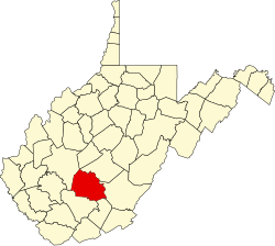
Boonesborough, West Virginia

Last updated

Boonesborough, West Virginia
USA West Virginia location map.svg
Red pog.svg
Boonesborough
Usa edcp location map.svg
Red pog.svg
Boonesborough
Coordinates: 38°7′46″N81°12′58″W / 38.12944°N 81.21611°W / 38.12944; -81.21611
Country United States
State West Virginia
County Fayette
Elevation
843 ft (257 m)
Time zone UTC-5 (Eastern (EST))
  Summer (DST) UTC-4 (EDT)
GNIS ID 1553948 [1]

Boonesborough is an unincorporated community in Fayette County, West Virginia, United States.

Related Research Articles

<span class="mw-page-title-main">Daniel Boone</span> American pioneer and frontiersman (1734–1820)

Daniel Boone was an American pioneer and frontiersman whose exploits made him one of the first folk heroes of the United States. He became famous for his exploration and settlement of Kentucky, which was then beyond the western borders of the Thirteen Colonies. In 1775, Boone blazed the Wilderness Road through the Cumberland Gap and into Kentucky, in the face of resistance from American Indians, for whom the area was a traditional hunting ground. He founded Boonesborough, one of the first English-speaking settlements west of the Appalachian Mountains. By the end of the 18th century, more than 200,000 people had entered Kentucky by following the route marked by Boone.

<span class="mw-page-title-main">Madison County, Kentucky</span> County in Kentucky, United States

Madison County is a county located in the central part of the U.S. state of Kentucky. At the 2020 census, its population was 92,701. Its county seat is Richmond. The county is named for Virginia statesman James Madison, who later became the fourth President of the United States.

<span class="mw-page-title-main">Transylvania Colony</span> Short-lived extra-legal colony in frontier Kentucky

The Transylvania Colony, also referred to as the Transylvania Purchase, was a short-lived, extra-legal colony founded in early 1775 by North Carolina land speculator Richard Henderson, who formed and controlled the Transylvania Company. Henderson and his investors had reached an agreement to purchase a vast tract of Cherokee lands west of the southern and central Appalachian Mountains through the acceptance of the Treaty of Sycamore Shoals with most leading Cherokee chieftains then controlling these lands. In exchange for the land the tribes received goods worth, according to the estimates of some scholars, about 10,000 British pounds. To further complicate matters, this frontier land was also claimed by the Virginia Colony and a southern portion by Province of North Carolina.

Boone may refer to:

<span class="mw-page-title-main">Boonesborough, Kentucky</span> Historic site in Kentucky

Boonesborough or Boonesboro is an unincorporated community in Madison County, Kentucky, United States. Founded by famed frontiersman Daniel Boone in 1775 as one of the first English-speaking settlements west of the Appalachian Mountains, Boonesborough lies in the central part of the state along the Kentucky River and is the site of Fort Boonesborough State Park, which includes the Kentucky River Museum. The park site has been rebuilt to look like a working fort of the time that Boone resided there.

The Kentucky River Museum is located in Boonesborough, Kentucky, in Fort Boonesborough State Park.

Boonesborough or Boonesboro may refer to a place in the United States:

Blackfish, was a Native American leader, war chief of the Chillicothe band of the Shawnee tribe.

<span class="mw-page-title-main">U.S. Route 227</span>

U.S. Route 227 was a U.S. Highway that was commissioned in Kentucky from 1928 to 1972, and ran from Richmond to Carrollton.

<span class="mw-page-title-main">Siege of Boonesborough</span> Frontier siege of the American Revolutionary War

The siege of Boonesborough was a military engagement which took place in September 1778 during the American Revolutionary War. On September 7, Shawnee chief Blackfish, who was allied to the British, led an attack on the Kentucky settlement of Boonesborough. Months before the battle, Blackfish had captured and adopted Daniel Boone, the founder of Boonesborough. Boone escaped the Shawnees in time to lead the defense of the settlement. Blackfish's siege was unsuccessful and was lifted after eleven days. Boone was then court-martialed by fellow officers who suspected him of harboring Loyalist sympathies. He was acquitted, but soon left the settlement.

Richard Callaway was an American frontiersman, military officer, politician, and hunter who was one of the first white settlers in modern-day Kentucky. Born in Essex County, Virginia, Callaway joined Daniel Boone in 1775 in marking the Wilderness Road into central Kentucky, becoming one of the founders of Boonesborough, Kentucky. He took part in organizing the short-lived Transylvania Colony. In 1776, two of Callaway's daughters, along with Daniel Boone's Jemima, were abducted outside Boonesborough by Cherokee and Shawnee raiding party. Callaway led one of a group of settlers in the successful rescue of the girls. His nephew Flanders Callaway later married Jemima Boone. In April 1777, Callaway and John Todd were elected to the Virginia legislature as burgesses from Kentucky County, Virginia.

<span class="mw-page-title-main">Fort Boonesborough State Park</span> State park in Kentucky, United States

Fort Boonesborough was a frontier fort in Kentucky, founded by Daniel Boone and his men following their crossing of the Kentucky River on April 1, 1775. The settlement they founded, known as Boonesborough, Kentucky, is Kentucky's second oldest European-American settlement. It served as a major frontier outpost during the American Revolutionary War, and survived into the early 19th century before its eventual abandonment. A National Historic Landmark now administered as part of Fort Boonesborough State Park, the site is one of the best-preserved archaeological sites of early westward expansion by British colonists in that period. It is located in Madison County, Kentucky off Kentucky Route 627.

<span class="mw-page-title-main">Indian Reserve (1763)</span> Native North American Areas

"Indian Reserve" is a historical term for the largely uncolonized land in North America that was claimed by France, ceded to Great Britain through the Treaty of Paris (1763) at the end of the Seven Years' War—also known as the French and Indian War—and set aside for the First Nations in the Royal Proclamation of 1763. The British government had contemplated establishing an Indian barrier state in a portion of the reserve west of the Appalachian Mountains, bounded by the Ohio and Mississippi rivers and the Great Lakes. British officials aspired to establish such a state even after the region was assigned to the United States in the Treaty of Paris (1783) ending the American Revolutionary War, but abandoned their efforts in 1814 after losing military control of the region during the War of 1812.

Peter Hackett was an American frontiersman.

<span class="mw-page-title-main">John Floyd (pioneer)</span>

James John Floyd (1750–1783) was an early settler of St. Matthews, Kentucky, and helped lay out Louisville. In Kentucky he served as a Colonel of the Kentucky Militia in which he participated in raids with George Rogers Clark and later became one of the first judges of Kentucky.

<span class="mw-page-title-main">Robert Trimble</span> US Supreme Court justice from 1826 to 1828

Robert Trimble was a lawyer and jurist who served as Justice of the Kentucky Court of Appeals, as United States district judge of the United States District Court for the District of Kentucky and as Associate Justice of the Supreme Court of the United States from 1826 to his death in 1828. During his brief Supreme Court tenure he authored several majority opinions, including the decision in Ogden v. Saunders, which was the only majority opinion that Chief Justice John Marshall ever dissented from during his 34 years on the Court.

Samuel South was born circa 1770 in Maryland. He was the second son of John South. The South family moved to Boonesborough when Samuel was still young. At the time, Boonesborough was in Fayette County in the District of Kentucky, a part of the state of Virginia. John South was in command of the militia at Boonesborough.

<span class="mw-page-title-main">Kentucky Route 388</span> State highway in Kentucky

Kentucky Route 388 (KY 388) is a 12.937-mile (20.820 km) state highway in Madison County, Kentucky, that runs from U.S. Route 25 Business, Kentucky Route 52, and South Second Street in downtown Richmond to Kentucky Route 627 just to the west of Boonesborough. The route passes through Fort Boonesborough State Park, and also comes within 0.5 miles (0.80 km) of Clark County.

References