
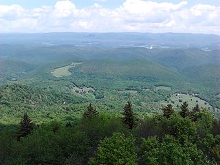
The Monongahela National Forest is a national forest located in the Allegheny Mountains of eastern West Virginia, USA. It protects over 921,000 acres of federally managed land within a 1,700,000 acres proclamation boundary that includes much of the Potomac Highlands Region and portions of 10 counties.

Shenandoah Mountain is a mountain ridge approximately 73 miles (117 km) long in Virginia and West Virginia. The steep, narrow, sandstone-capped ridge extends from northern Bath County, Virginia to southern Hardy County, West Virginia. Along the way, its crest defines the borders between Highland and Augusta counties, Virginia, and between Pendleton County, West Virginia, and Rockingham County, Virginia. Its high point is 4397’/1340 m Reddish Knob along the Virginia/West Virginia border.
Bald Knob is the highest summit of Back Allegheny Mountain in Pocahontas County, West Virginia and is part of Cass Scenic Railroad State Park. At an altitude of 4,843 feet (1,476 m) above sea level, Bald Knob is the third-highest point in West Virginia and the Allegheny Mountains.

Cass Scenic Railroad State Park is a state park and heritage railroad located in Cass, Pocahontas County, West Virginia.
The Potomac Highlands of West Virginia centers on five West Virginian counties in the upper Potomac River watershed in the western portion of the state's Eastern Panhandle, bordering Maryland and Virginia. Because of geographical proximity, similar topography and landscapes, and shared culture and history, the Potomac Highlands region also includes Pocahontas, Randolph, and Tucker counties, even though they are in the Monongahela River or New River watersheds and not that of the Potomac River.
Patterson Creek Mountain is a mountain ridge that forms the border between Mineral and Hampshire counties and Grant and Hardy Counties in West Virginia's Eastern Panhandle. The mountain's namesake, Patterson Creek, parallels its western flank. The southern end of the Patterson Creek Mountain is near the confluence of Lunice Creek and the South Branch Potomac River and its northern end is located southwest of Springfield. The mountain reaches its highest elevation at Charles Knob.
Holly River State Park is a state park located in Webster County, West Virginia. Situated on the Left Fork of the Holly River near the town of Hacker Valley, it is the second largest park in the West Virginia state park system with a total of 8,294 acres (3,356 ha). The park features over 42 miles (68 km) of hiking trails, ten vacation cabins, an 88-unit campground, and many recreation and picnic areas.

Spruce Knob–Seneca Rocks National Recreation Area is a national recreation area in the Monongahela National Forest of eastern West Virginia.

Reddish Knob of Shenandoah Mountain is one of the highest points in Virginia, rising 4,397 feet (1,340 m). A narrow, paved road reaches the summit from Harrisonburg, Virginia.

North Mountain is a mountain ridge within the Ridge-and-valley Appalachians in the U.S. states of Virginia and West Virginia.

Allegheny Mountain is a major mountain ridge in the southern range of the Allegheny Mountains, part of the Appalachian Mountains. It forms the Eastern Continental Divide along part of its course and also serves as part of the Virginia–West Virginia state line.

North Fork Mountain is a quartzite-capped mountain ridge in the Ridge and Valley physiographic province of the Allegheny Mountains, also known as the High Alleghenies or Potomac Highlands, of eastern West Virginia. Kile Knob, at 4,588 feet, is the mountain's highest point, and Panther Knob and Pike Knob are nearly as high.

Back Allegheny Mountain is a long mountain ridge in eastern West Virginia. It is part of the Shavers Fork Mountain Complex in the Allegheny Range of the Appalachians.

Shavers Mountain, is a high and rugged ridge situated in the Allegheny Mountains of eastern West Virginia. It is about 35 miles (56 km) long, north to south, and several of its peaks exceed 4,000 feet (1,200 m) in elevation. Shavers Mountain is notable for being "bookended", at its northern and southern ends, by two exceptional natural areas: the Otter Creek Wilderness and the Gaudineer Scenic Area, respectively, both of which preserve small stands of old growth forest on the mountain.

Gaudineer Knob is a mountain summit on the Randolph/Pocahontas County line in eastern West Virginia, US. It is the highest elevation of Shavers Mountain, a ridge of the Alleghenies, and is located about 1.7 miles (2.7 km) east of Cheat Bridge. The Gaudineer Knob Lookout Tower, an important US Forest Service (USFS) fire tower, formerly occupied the crown of the knob.

Spruce Mountain, located in eastern West Virginia, is the highest ridge of the Allegheny Mountains. The whale-backed ridge extends for only 16 miles (26 km) from northeast to southwest, but several of its peaks exceed 4,500 feet (1,400 m) in elevation. The summit, Spruce Knob, is the highest Allegheny Mountain point both in the state and the entire range, which spans four states.
The coal towns, or "coal camps" of Fayette County, West Virginia were situated to exploit the area's rich coal seams. Many of these towns were located in deep ravines that afforded direct access to the coal through the hillsides, allowing mined coal to be dropped or conveyed downhill to railway lines at the valley floor. Many of these encampments were set up as company towns, and when their mines closed, the towns vanished. A few, like Thurmond, West Virginia, have survived in a reduced state. Fayette County covers portions of three coalfields: the New River Coalfield, the Kanawha Coalfield and the Greenbrier Coalfield. Below is a partial list of known coal towns within the three coalfields: the New River Coalfield, the Kanawha Coalfield and the Greenbrier Coalfield. More may be found here
Beelick Knob is an unincorporated community and coal town in Fayette County, West Virginia, United States.


