Robson, West Virginia | |
---|---|
Unincorporated community | |
Nickname(s): SIRI | |
Coordinates: 38°06′11″N81°15′00″W / 38.10306°N 81.25000°W Coordinates: 38°06′11″N81°15′00″W / 38.10306°N 81.25000°W | |
Country | United States |
State | West Virginia |
County | Fayette |
Elevation [1] | 876 ft (267 m) |
Time zone | Eastern (EST) (UTC-5) |
• Summer (DST) | EDT (UTC-4) |
ZIP code | 25173 |
Area code(s) | 304 |
FIPS code | 54-54019 |
GNIS feature ID | 1555495 [1] |
[2] |
Robson is an unincorporated community in Fayette County, West Virginia, United States, situated primarily on the banks of Loup Creek. Robson is served by State Highway 61, and is located 8 miles (13 km) from Montgomery and 15 miles (24 km) from Oak Hill. Robson's Post Office serves the smaller communities of Beards Fork and Mulberry.
In law, an unincorporated area is a region of land that is not governed by a local municipal corporation; similarly an unincorporated community is a settlement that is not governed by its own local municipal corporation, but rather is administered as part of larger administrative divisions, such as a township, parish, borough, county, city, canton, state, province or country. Occasionally, municipalities dissolve or disincorporate, which may happen if they become fiscally insolvent, and services become the responsibility of a higher administration. Widespread unincorporated communities and areas are a distinguishing feature of the United States and Canada. In most other countries of the world, there are either no unincorporated areas at all, or these are very rare; typically remote, outlying, sparsely populated or uninhabited areas.
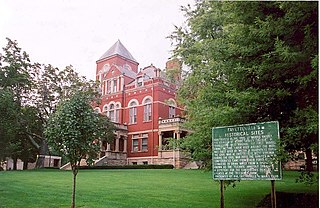
Fayette County is a county in the U.S. state of West Virginia. As of the 2010 census, the population was 46,039. Its county seat is Fayetteville. It is part of the Beckley, WV Metropolitan Statistical Area in Southern West Virginia.
West Virginia is a state located in the Appalachian region in the Southern United States and is also considered to be a part of the Middle Atlantic States. It is bordered by Pennsylvania to the north, Maryland to the east and northeast, Virginia to the southeast, Kentucky to the southwest, and Ohio to the northwest. West Virginia is the 41st largest state by area, and is ranked 38th in population. The capital and largest city is Charleston.
The community was named after James Robson, an early settler. [3]
Beards Fork is a census-designated place (CDP) and coal town in Fayette County, West Virginia, United States that was founded as a coal town. As of the 2010 census, its population was 199.
Williamsburg is a small unincorporated community in Greenbrier County, West Virginia, United States. Williamsburg is 10 miles (16 km) west of Falling Spring. Williamsburg has a post office with ZIP code 24991.
Clearco is an unincorporated community and coal town in Greenbrier County, West Virginia, United States. Clearco is 8 miles (13 km) east-northeast of Quinwood.
Nallen is an unincorporated community in Fayette and Nicholas counties, West Virginia, United States. Nallen is located along West Virginia Route 41 12 miles (19 km) south of Summersville. Nallen has a post office with ZIP code 26680.
Russellville is an unincorporated community in Fayette County, West Virginia, United States. Russellville is located along West Virginia Route 41 14.5 miles (23.3 km) south of Summersville.
Shawver is an unincorporated community in Fayette and Greenbrier counties, West Virginia, United States. Shawver is 5 miles (8.0 km) northeast of Meadow Bridge.
Sunlight is an unincorporated community in Greenbrier County, West Virginia, United States. Sunlight is 6 miles (9.7 km) west of Falling Spring.
Linn is an unincorporated community in Gilmer County, West Virginia, United States. Linn is located at the junction of U.S. Route 33, U.S. Route 119, and West Virginia Route 47, along Leading Creek, 8 miles (13 km) northeast of Glenville. Linn has a post office with ZIP code 26384.
Hansford is an unincorporated community in Kanawha County, West Virginia, United States. Hansford is located along the Kanawha River and West Virginia Route 61 1 mile (1.6 km) southwest of Pratt. Hansford has a post office with ZIP code 25103.
Summerlee is an unincorporated community and coal town in Fayette County, West Virginia, United States. Summerlee is 2 miles (3.2 km) north-northwest of Oak Hill.
Maplewood is an unincorporated community in Fayette County, West Virginia, United States. Maplewood is located on West Virginia Route 41 6.5 miles (10.5 km) northwest of Meadow Bridge.
Riverside is an unincorporated community in Kanawha County, West Virginia, United States. Riverside is located on the north bank of the Kanawha River and U.S. Route 60 1 mile (1.6 km) southeast of Glasgow.
Kingston is an unincorporated community and coal town in Fayette County, West Virginia, United States. Kingston is 8.5 miles (13.7 km) west of Oak Hill.
Surveyor is an unincorporated community in Raleigh County, West Virginia, United States. Surveyor is located on West Virginia Route 305 7 miles (11 km) west of Beckley. Surveyor has a post office with ZIP code 25932.
Naoma is an unincorporated community in Raleigh County, West Virginia, United States. Naoma is located on West Virginia Route 3 7.5 miles (12.1 km) south-southeast of Whitesville. Naoma has a post office with ZIP code 25140.
Cunard is an unincorporated community in Fayette County, West Virginia, United States. Cunard is 5 miles (8.0 km) southeast of Fayetteville.
Wallace is an unincorporated community in Kanawha County, West Virginia, United States. Wallace is 7 miles (11 km) north of Charleston.
Carbon is an unincorporated community in Kanawha County, West Virginia, United States, along Cabin Creek. Carbon is 7.5 miles (12.1 km) northeast of Whitesville.
Burnwell is an unincorporated community in Kanawha County, West Virginia, United States. Burnwell is 10.5 miles (16.9 km) east-northeast of Sylvester.
Dickinson, also known as Quincy, is an unincorporated community in Kanawha County, West Virginia, United States. Dickinson is located on the north bank of the Kanawha River 3 miles (4.8 km) southeast of Belle. The community is served by U.S. Route 60.
This article about a location in Fayette County, West Virginia is a stub. You can help Wikipedia by expanding it. |