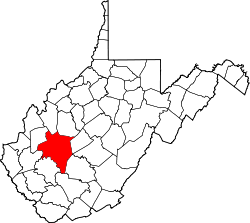
Etowah, West Virginia

Last updated

Etowah, West Virginia
USA West Virginia location map.svg
Red pog.svg
Etowah
Location within West Virginia and the United States
Usa edcp location map.svg
Red pog.svg
Etowah
Etowah (the United States)
Coordinates: 38°22′34″N81°36′3″W / 38.37611°N 81.60083°W / 38.37611; -81.60083
Country United States
State West Virginia
County Kanawha
Elevation
610 ft (190 m)
Time zone UTC-5 (Eastern (EST))
  Summer (DST) UTC-4 (EDT)
GNIS ID 1554415 [1]

Etowah is an unincorporated community in Kanawha County, West Virginia, United States.

The name Etowah is Native American in origin. [2]

Related Research Articles

<span class="mw-page-title-main">Calhoun County, Alabama</span> County in Alabama, United States

Calhoun County is a county in the east central part of the U.S. state of Alabama. As of the 2020 census, the population was 116,441. Its county seat is Anniston. It is named in honor of John C. Calhoun, a US Senator from South Carolina who was a staunch supporter of slavery.

<span class="mw-page-title-main">Etowah County, Alabama</span> County in Alabama, United States

Etowah County is a county located in the northeastern part of the U.S. state of Alabama. As of the 2020 census the population was 103,436. Its county seat is Gadsden. Its name is from a Cherokee word meaning "edible tree". In total area, it is the smallest county in Alabama, albeit one of the most densely populated. Etowah County comprises the Gadsden Metropolitan Statistical Area.

<span class="mw-page-title-main">Dawson County, Georgia</span> County in Georgia, United States

Dawson County is a county located in the northeast region of the U.S. state of Georgia. As of the 2020 census, the population was 26,798 up from 22,330 in 2010. The county seat is Dawsonville.

<span class="mw-page-title-main">Cherokee County, Georgia</span> County in Georgia, United States

Cherokee County is located in the US state of Georgia. As of the 2020 Census, the population was 266,620. The county seat is Canton. The county Board of Commissioners is the governing body, with members elected to office. Cherokee County is included in the Atlanta Metropolitan Area.

<span class="mw-page-title-main">Gadsden, Alabama</span> City in Alabama, United States

Gadsden is the county seat of Etowah County in the U.S. state of Alabama. It is located on the Coosa River about 56 miles (90 km) northeast of Birmingham and 90 miles (140 km) southwest of Chattanooga, Tennessee. It is the primary city of the Gadsden Metropolitan Statistical Area, which has a population of 103,931. The population 33,945 at the 2020 census.

<span class="mw-page-title-main">Etowah, Arkansas</span> Town in Arkansas, United States

Etowah is a town in Mississippi County, Arkansas, United States. The population was 254 at the 2020 census, down from 351 in 2010.

<span class="mw-page-title-main">Etowah, North Carolina</span> Census-designated place in Henderson County, North Carolina, USA

Etowah is an unincorporated community and census-designated place (CDP) in Henderson County, North Carolina, United States. The population was 6,944 at the 2010 census. It is part of the Asheville Metropolitan Statistical Area.

<span class="mw-page-title-main">French Broad River</span> River in North Carolina and Tennessee, United States

The French Broad River is a river in the U.S. states of North Carolina and Tennessee. It flows 218 miles (351 km) from near the town of Rosman in Transylvania County, North Carolina, into Tennessee, where its confluence with the Holston River at Knoxville forms the beginning of the Tennessee River. The river flows through the counties of Transylvania, Buncombe, Henderson, and Madison in North Carolina, and Cocke, Jefferson, Sevier, and Knox in Tennessee. It drains large portions of the Pisgah National Forest and the Cherokee National Forest.

Gad or GAD may refer to:

<span class="mw-page-title-main">Etowah River</span> River in Georgia, U.S.

The Etowah River is a 164-mile-long (264 km) waterway that rises northwest of Dahlonega, Georgia, north of Atlanta. On Matthew Carey's 1795 map the river was labeled "High Town River". On later maps, such as the 1839 Cass County map, it was referred to as "Hightower River", a name that was used in most early Cherokee records.

<span class="mw-page-title-main">Etowah Indian Mounds</span> Archaeological site in Georgia, U.S.

Etowah Indian Mounds (9BR1) are a 54-acre (220,000 m2) archaeological site in Bartow County, Georgia, south of Cartersville. Built and occupied in three phases, from 1000–1550 CE, the prehistoric site is located on the north shore of the Etowah River.

Etowah is a Muskogee (Creek) word for 'town'/'people'/'tribe', and may also refer to:

<span class="mw-page-title-main">Sutallee, Georgia</span> Unincorporated community in Georgia, U.S.

Sutallee is an unincorporated community in western Cherokee County, Georgia, United States. Located about two miles northwest of current-day Lake Allatoona, it is one of the county's earliest white settlements. It is believed that former Georgia Governor and U.S. Senator Joseph E. Brown maintained a farm in the area, on lowlands near the Etowah River, and was there harvesting wheat when told of the surprising news that he had been nominated for governor. Sutallee derives its unique name, which is often spelled "Sutalee" or "Suttallee", from an old Cherokee village that was located near the Etowah River named "Sutali" — the Cherokee word for the number six. Sixes, a community that sits on the eastern side of Lake Allatoona, also derives its name from this Native American village. Today, Sutallee is traversed by Georgia Highway 20 and remains mostly rural.

<span class="mw-page-title-main">Little River (Etowah River tributary)</span> River in the United States

The Little River is a 29.3-mile-long (47.2 km) tributary of the Etowah River in the U.S. state of Georgia in the United States.

<span class="mw-page-title-main">Gallant, Alabama</span> Unincorporated community in Alabama, United States

Gallant, also known as Clear Springs or Greasy Cove, is a census-designated place and unincorporated community in Etowah, and St. Clair counties, Alabama, United States. It lies west of the city of Gadsden, the county seat of Etowah County. As of the 2010 census, its population was 855. It has a post office with the ZIP code 35972.

The Battle of Hightower in 1793 was part of the Cherokee–American wars, in which the Cherokee sought to defend tribal territory from increasing settlement by the citizens of the new United States. This particular battle took place at the Cherokee village of High Town (Itawayi), overlooking downtown Rome in present-day Floyd County, Georgia, resulting in the defeat of the Cherokee by a force led by John Sevier, future Governor of Tennessee.

Barnabus is an unincorporated community in Logan County, West Virginia, United States, along West Virginia Route 44 and Island Creek. Barnabus is 7.5 miles (12.1 km) south of Logan. Barnabus was named for one of its founding citizens, Barnabus Curry.

<span class="mw-page-title-main">Wulfing cache</span>

The Wulfing cache, or Malden plates, are eight Mississippian copper plates crafted by peoples of the Mississippian culture. They were discovered in Dunklin County, Missouri in 1906 by Ray Grooms, a farmer, while plowing a field south of Malden. The repousséd copper plates were instrumental to archaeologists' developing the concept known as the Southeastern Ceremonial Complex.

<span class="mw-page-title-main">Etowah plates</span>

The Etowah plates, including the Rogan Plates, are a collection of Mississippian copper plates discovered in Mound C at the Etowah Indian Mounds near Cartersville, Georgia. Many of the plates display iconography that archaeologists have classified as part of the Southeastern Ceremonial Complex (S.E.C.C.), specifically "Birdman" imagery associated with warriors and the priestly elite. The plates are a combination of foreign imports and local items manufactured in emulation of the imported style. The designs of the Rogan plates are in the Classic Braden style from the American Bottom area. It is generally thought that some of the plates were manufactured at Cahokia before ending up at sites in the Southeast.

Keener, also known as Greenwood, is an unincorporated community in Etowah County, Alabama, United States.

References

  1. U.S. Geological Survey Geographic Names Information System: Etowah, West Virginia
  2. Kenny, Hamill (1945). West Virginia Place Names: Their Origin and Meaning, Including the Nomenclature of the Streams and Mountains. Piedmont, WV: The Place Name Press. p. 233.