Coal Fork, West Virginia

Last updated
Coal Fork, West Virginia
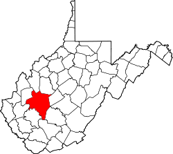
Kanawha County West Virginia incorporated and unincorporated areas Coal Fork highlighted.svg
Location in Kanawha County and state of West Virginia.
Coordinates: 38°19′2″N81°31′37″W / 38.31722°N 81.52694°W / 38.31722; -81.52694 Coordinates: 38°19′2″N81°31′37″W / 38.31722°N 81.52694°W / 38.31722; -81.52694
Country United States
State West Virginia
County Kanawha
Area
  Total5.1 sq mi (13.3 km2)
  Land5.1 sq mi (13.3 km2)
  Water0.0 sq mi (0.0 km2)
Elevation
650 ft (198 m)
Population
 (2010)
  Total1,233
  Density240/sq mi (93/km2)
Time zone UTC-5 (Eastern (EST))
  Summer (DST) UTC-4 (EDT)
Area code(s) 304
FIPS code 54-16612 [1]
GNIS feature ID1537443 [2]

Coal Fork is an unincorporated census-designated place (CDP) in Kanawha County, West Virginia, United States. It is part of a larger unincorporated community known as Campbells Creek, approximately 10 minutes east of Charleston, West Virginia. The population was 1,233 at the 2010 census. [3]

Contents

Geography

Coal Fork is located at 38°19′2″N81°31′37″W / 38.31722°N 81.52694°W / 38.31722; -81.52694 (38.317216, -81.526864). [4]

According to the United States Census Bureau, the Coal Fork CDP has a total area of 5.1 square miles (13.3 km2), all of it land.

Demographics

As of the census [1] of 2000, there were 1,350 people, 581 households, and 415 families living in the community. The population density was 262.8 people per square mile (101.4/km2). There were 614 housing units at an average density of 119.5/sq mi (46.1/km2). The racial makeup of the community was 98.67% White, 0.30% African American, 0.15% Native American, and 0.89% from two or more races. Hispanic or Latino of any race were 0.67% of the population.

There were 581 households, out of which 24.8% had children under the age of 18 living with them, 54.2% were married couples living together, 13.4% had a female householder with no husband present, and 28.4% were non-families. 26.3% of all households were made up of individuals, and 13.8% had someone living alone who was 65 years of age or older. The average household size was 2.32 and the average family size was 2.75.

The community's age distribution is 19.7% under the age of 18, 6.7% from 18 to 24, 26.7% from 25 to 44, 28.0% from 45 to 64, and 18.9% who were 65 years of age or older. The median age was 43 years. For every 100 females, there were 95.1 males. For every 100 females age 18 and over, there were 91.5 males.

The median income for a household in the community was $26,250, and the median income for a family was $29,808. Males had a median income of $25,568 versus $21,667 for females. The per capita income for the community was $14,002. About 16.5% of families and 18.0% of the population were below the poverty line, including 17.0% of those under age 18 and 10.9% of those age 65 or over.

Related Research Articles

Healy, Alaska Census-designated place in Alaska, United States

Healy is a census-designated place (CDP) and the borough seat of Denali Borough in the U.S. state of Alaska. The population was 1,021 at the 2010 census, up from 1,000 in 2000.

Plantation Island, Florida Census-designated place in Florida

Plantation Island is a census-designated place (CDP) in Collier County, Florida, United States. The population was 163 at the 2010 census. It is part of the Naples–Marco Island Metropolitan Statistical Area.

Nassau Village-Ratliff, Florida CDP in Florida, United States

Nassau Village-Ratliff is a census-designated place (CDP) in Nassau County, Florida, United States. The population was 5,337 at the 2010 census.

McRoberts, Kentucky Census-designated place in Kentucky, United States

McRoberts is an unincorporated community and census-designated place (CDP) in Letcher County, Kentucky, United States. The population was 784 at the 2010 United States Census, down from 921 at the 2000 census. McRoberts is in the Eastern Kentucky Coalfield region.

Cordaville, Massachusetts CDP in Massachusetts, United States

Cordaville is a census-designated place (CDP) in the town of Southborough in Worcester County, Massachusetts, United States. The population was 2,650 at the 2010 census.

Willow Creek, Montana Census-designated place in Montana, United States

Willow Creek is an unincorporated community and census-designated place (CDP) in Gallatin County, Montana, United States. The population was 210 at the 2010 census. It is part of the Bozeman, MT Micropolitan Statistical Area.

Noyack, New York Census-designated place in New York, United States

Noyack is a hamlet and census-designated place (CDP) in Suffolk County, New York, United States. The CDP population was 3,568 at the 2010 census.

South Gastonia, North Carolina Neighborhood in Gaston, North Carolina, United States

South Gastonia is a neighborhood of Gastonia in Gaston County, North Carolina, United States. The population was 5,433 at the 2000 census, at which time it was erroneously listed as a census-designated place. Majority of the community has now been annexed into the city of Gastonia and is now considered to be a neighborhood on the southside of Gastonia.

Choctaw Lake, Ohio CDP in Ohio, United States

Choctaw Lake is a census-designated place (CDP) in Madison County, Ohio, United States. The population was 1,562 at the 2000 census.

North Fork Village, Ohio Former CDP in Ohio, United States

North Fork Village is an unincorporated community and former census-designated place (CDP) in Ross County, Ohio, United States. The population was 1,726 at the 2000 census. It was not delineated as a CDP for the 2010 census.

Lawnton, Pennsylvania Census-designated place in Pennsylvania, United States

Lawnton is an unincorporated area and census-designated place (CDP) in Swatara Township, Dauphin County, Pennsylvania, United States. The population was 3,813 at the 2010 census. It is part of the Harrisburg–Carlisle Metropolitan Statistical Area.

Baring, Washington Census-designated place in Washington, United States

Baring is an unincorporated community and census-designated place (CDP) in King County, Washington, United States. The population was 220 at the 2010 census. It is located on U.S. Highway 2 about 23 miles (37 km) west of Stevens Pass, along a very flat and straight three-mile section of highway that has been dubbed the "Baring Straight", since US-2 is otherwise hilly and curvy through the mountains.

Madison, West Virginia City in West Virginia, United States

Madison is a city and former coal town in Boone County, West Virginia, United States. The population was 3,076 at the 2010 census. It is the county seat of Boone County.

Powellton, West Virginia CDP in West Virginia, United States

Powellton is a census-designated place (CDP) in Fayette County, West Virginia, United States. The population was 619 at the 2010 census.

Alum Creek, West Virginia CDP in West Virginia, United States

Alum Creek is a census-designated place (CDP) in Kanawha and Lincoln counties along the Coal River in the U.S. state of West Virginia. It had a population of 1,749 at the 2010 census.

Mallory, West Virginia CDP in West Virginia, United States

Mallory is a census-designated place (CDP) in Logan County, West Virginia, United States. The population was 1,654 at the 2010 census.

Red Jacket, West Virginia Census-designated place in West Virginia, United States

Red Jacket is a census-designated place (CDP) in Mingo County, West Virginia, in the United States. The population was 581 at the 2010 census. The community was named for Red Jacket, a Seneca chief.

Coal City, West Virginia Census-designated place in West Virginia, United States

Coal City is a census-designated place (CDP) in Raleigh County, West Virginia, United States. The population was 1,815 at the 2010 census. Coal City's population is composed of other surrounding unincorporated communities.

Stanaford, West Virginia Census-designated place in West Virginia, United States

Stanaford is a census-designated place (CDP) and coal town in Raleigh County, West Virginia, United States. The population was 1,350 at the 2010 census.

Duncott, Pennsylvania CDP in Pennsylvania, United States

Duncott is a census-designated place (CDP) in Schuylkill County, Pennsylvania, United States, near Minersville in the Coal Region. The population was 76 at the 2000 census. It is located in Cass Township.

References

  1. 1 2 "U.S. Census website". United States Census Bureau . Retrieved 2008-01-31.
  2. "US Board on Geographic Names". United States Geological Survey. 2007-10-25. Retrieved 2008-01-31.
  3. "U.S. Census website". United States Census Bureau . Retrieved 2011-05-14.
  4. "US Gazetteer files: 2010, 2000, and 1990". United States Census Bureau. 2011-02-12. Retrieved 2011-04-23.