South Charleston, West Virginia

Last updated

South Charleston, West Virginia
Criel Mound.jpg
Flag of South Charleston, West Virginia.svg
Seal of South Charleston, West Virginia.png
Kanawha County West Virginia Incorporated and Unincorporated areas South Charleston Highlighted.svg
Location of South Charleston in Kanawha County, West Virginia.
Coordinates: 38°21′9″N81°42′43″W / 38.35250°N 81.71194°W / 38.35250; -81.71194
CountryUnited States
StateFlag of West Virginia.svg  West Virginia
County Kanawha
Founded1906
Incorporated1919
Government
  MayorFrank A. Mullens, Jr. (R)
Area
[1]
   City 9.53 sq mi (24.69 km2)
  Land8.64 sq mi (22.38 km2)
  Water0.89 sq mi (2.31 km2)
Elevation
604 ft (183 m)
Population
 (2020) [2]
   City 13,639
  Estimate 
(2021) [2]
13,352
  Density1,394.01/sq mi (538.22/km2)
   Urban
153,199 (US: 214th)
   Metro
222,878 (US: 198th)
Time zone UTC-5 (EST)
  Summer (DST) UTC-4 (EDT)
ZIP codes
25303, 25309
Area code 304
FIPS code 54-75292
GNIS feature ID1555663 [3]
Website City of South Charleston

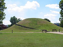
South Charleston is a city in Kanawha County, West Virginia, United States. It is located to the west of the state capital of Charleston. The population was 13,639 at the 2020 census. [2] It was established in 1906, but not incorporated until 1917. [4] The Criel Mound built circa 0 BCE by the Adena culture is adjacent to the city's downtown business district.

Contents

It is home to the Charleston Ordnance Center, a former naval munitions factory established for use in World War I.

The city is serviced by Interstate 64, U.S. Route 60, U.S. Route 119, West Virginia Route 601 and West Virginia Route 214, and is adjacent to the Kanawha River. The city is serviced by the Kanawha Valley Regional Transportation Authority bus system. A general aviation airfield, Mallory Airport, is located off Chestnut Street, approximately two miles south of U.S. Route 60, with the nearest commercial aviation service being at Yeager Airport in Charleston. South Charleston serves as the headquarters to the West Virginia Division of Natural Resources and the West Virginia State Police.

History

South Charleston was established in 1906, but not incorporated until 1917. [4]

Leonidas Henrie Oakes Sr. (1843-1894) was a member of the West Virginia State Legislature. His son, Leonidas Henrie Oakes Jr. (1873-1949) was the mayor of South Charleston for many years. He was mayor from 1920 to 1921 and also from 1930 to 1946. He acquired funds to build the Thomas Memorial Hospital and also the Oakes Field in South Charleston, West Virginia. He was instrumental in developing recreational activities for the youth of the city.

It is home to the Charleston Ordnance Center, a former naval munitions factory established for use in World War I. [5] [6] It employed over 11,000 workers and produced 130,000 gun barrels for U.S. warships. [7]

Geography

South Charleston is located at 38°21′9″N81°42′43″W / 38.35250°N 81.71194°W / 38.35250; -81.71194 (38.352455, −81.712001).

According to the United States Census Bureau, the city has a total area of 8.51 square miles (22.04 km2), of which 7.61 square miles (19.71 km2) is land and 0.90 square miles (2.33 km2) is water. [8]

Climate

The climate in this area is characterized by hot, humid summers and generally mild to cool winters. According to the Köppen Climate Classification system, South Charleston has a humid subtropical climate, abbreviated "Cfa" on climate maps. [9]

Demographics

Historical population
CensusPop.Note
1920 3,650
1930 5,90461.8%
1940 10,37775.8%
1950 16,68660.8%
1960 19,18014.9%
1970 16,333−14.8%
1980 15,968−2.2%
1990 13,645−14.5%
2000 13,390−1.9%
2010 13,4500.4%
2020 13,6391.4%
2021 (est.)13,352 [2] −2.1%
U.S. Decennial Census [10]

The median income for a household in the city was $37,905, and the median income for a family was $50,528. Males had a median income of $39,036 versus $25,978 for females. The per capita income for the city was $24,928. About 9.7% of families and 12.1% of the population were below the poverty line, including 19.4% of those under age 18 and 9.8% of those age 65 or over.

2010 census

As of the census [11] of 2010, there were 13,450 people, 6,283 households, and 3,675 families residing in the city. The population density was 1,767.4 inhabitants per square mile (682.4/km2). There were 6,819 housing units at an average density of 896.1 per square mile (346.0/km2). The racial makeup of the city was 86.9% White, 8.4% African American, 0.3% Native American, 1.1% Asian, 0.3% from other races, and 3.0% from two or more races. Hispanic or Latino of any race were 1.0% of the population.

There were 6,283 households, of which 26.1% had children under the age of 18 living with them, 39.6% were married couples living together, 15.5% had a female householder with no husband present, 3.4% had a male householder with no wife present, and 41.5% were non-families. 36.0% of all households were made up of individuals, and 13.4% had someone living alone who was 65 years of age or older. The average household size was 2.14 and the average family size was 2.77.

The median age in the city was 42.3 years. 20.9% of residents were under the age of 18; 6.5% were between the ages of 18 and 24; 25.7% were from 25 to 44; 29.5% were from 45 to 64; and 17.6% were 65 years of age or older. The gender makeup of the city was 45.7% male and 54.3% female.

D Street D Street.JPG
D Street

Economy

In South Charleston are the headquarters of International Industries, the parent company of a group of subsidiaries founded in 1947 by James H. "Buck" Harless, based primarily in natural resources such as coal and timber, but which also include the manufacturing, hotel and real estate industries. [12]

Education

There are six elementary schools in South Charleston: Montrose Elementary, Ruthlawn Elementary, Richmond Elementary, Alum Creek Elementary, Bridgeview Elementary, and Weberwood Elementary. The main middle school is South Charleston Middle School (SCMS), which is located on 3rd Ave. SCMS houses grades 6–8. South Charleston High School (SCHS) is one of eight high schools in Kanawha County. SCHS is located on Eagle Way and houses grades 9–12. There are also two colleges located in the city. A South Charleston campus for BridgeValley Community and Technical College is located at the former Dow Chemical research facility and the Marshall University – South Charleston Campus is a branch of Marshall University.

Arts and culture

South Charleston attractions include Criel Mound (also known as the South Charleston Adena Burial Mound), and the South Charleston Museum. The South Charleston Museum is located in the historic LaBelle Theater on D Street, and features a West Virginia Film Series, Open Mic Night, exhibitions, and other events.

The city is also home to a community center, an ice arena, Little Creek Park, Little Creek Country Club and Joplin Park. The Interpretive Center is located at 313 D street and features the Appalachian trail, the Mound, Indian artifacts, arrowheads, chemical history and artifacts, and a Belgium display depicting the first business in South Charleston also Blenko birthday pieces donated by Pearl Watson.

Notable people

See also

Related Research Articles

<span class="mw-page-title-main">Charleston, West Virginia</span> Capital city of West Virginia, U.S.

Charleston is the capital and most populous city of the U.S. state of West Virginia and the seat of Kanawha County. Located at the confluence of the Elk and Kanawha rivers, the city had a population of 48,864 at the 2020 census and an estimated population of 48,018 in 2021. The Charleston metropolitan area had 210,605 residents in 2020.

<span class="mw-page-title-main">Kanawha County, West Virginia</span> County in West Virginia, United States

Kanawha County is a county in the U.S. state of West Virginia. As of the 2020 census, the population was 180,745, making it West Virginia's most populous county. The county seat is Charleston, which is also the state capital and most populous city. Kanawha County is part of the Charleston, WV Metropolitan Statistical Area.

<span class="mw-page-title-main">Boone County, West Virginia</span> County in West Virginia, United States

Boone County is a county in the U.S. state of West Virginia. As of the 2020 census, the population was 21,809. Its county seat is Madison. Boone County is part of the Charleston, WV Metropolitan Statistical Area. Leading industries and chief agricultural products in Boone County include coal, lumber, natural gas, tobacco, and strawberries.

<span class="mw-page-title-main">Shepherdsville, Kentucky</span> City in Kentucky, United States

Shepherdsville is a home rule-class city on the Salt River in Bullitt County, Kentucky, in the United States. It is the second largest city and seat of its county, located just south of Louisville. The population was 14,201 during the 2020 U.S. Census.

<span class="mw-page-title-main">Buchanan, Virginia</span> Town in Virginia, United States

Buchanan is a town in Botetourt County, Virginia, United States. The population was 1,196 at the 2020 census. It is part of the Roanoke Metropolitan Statistical Area. It was the western terminus of the James River and Kanawha Canal when construction on the canal ended.

<span class="mw-page-title-main">Glenville, West Virginia</span> Town in West Virginia, United States

Glenville is a town in and the county seat of Gilmer County, West Virginia, United States, along the Little Kanawha River. The population was 1,128 at the 2020 census. It is the home of Glenville State University.

<span class="mw-page-title-main">Clendenin, West Virginia</span> Town in West Virginia, United States

Clendenin is a town in Kanawha County, West Virginia, United States, situated along the Elk River. The population was 850 at the 2020 census.

<span class="mw-page-title-main">Dunbar, West Virginia</span> City in West Virginia, United States

Dunbar is a city in Kanawha County, West Virginia, United States, situated along the Kanawha River. The population was 7,479 at the 2020 census.

<span class="mw-page-title-main">Elkview, West Virginia</span> Census-designated place in West Virginia, United States

Elkview is a census-designated place (CDP) in Kanawha County, West Virginia, United States. The population was 1,222 at the 2010 census. It is named after the Elk River, which flows into the Kanawha River.

<span class="mw-page-title-main">Handley, West Virginia</span> Town in West Virginia, United States

Handley is a town in Kanawha County, West Virginia, United States. The population was 224 at the 2020 census. Handley was first established in 1877 and known as Upper Creek until July 29, 1881, when its name was changed to Handley for pioneer settlers who farmed the area. Handley has the distinction of bearing a name like no other town in the United States. The town was incorporated November 1972.

<span class="mw-page-title-main">Sissonville, West Virginia</span> Census-designated place in West Virginia, United States

Sissonville is a census-designated place (CDP) in Kanawha County, West Virginia, United States, along the Pocatalico River. The population was 4,028 at the 2010 census. Sissonville is located within 14 miles of Charleston, the state capital.

<span class="mw-page-title-main">St. Albans, West Virginia</span> City in West Virginia, United States

St. Albans is a city in western Kanawha County, West Virginia, United States, at the confluence of the Kanawha and Coal rivers. The population was 10,861 at the 2020 census. It is part of the Charleston metropolitan area.

<span class="mw-page-title-main">Eleanor, West Virginia</span> Town in West Virginia, United States

Eleanor is a town in Putnam County, West Virginia, United States, along the Kanawha River. Its population was 1,548 at the 2020 census. It is part of the Huntington–Ashland metropolitan area. The town, named for Eleanor Roosevelt, was established as a New Deal project in the 1930s like other Franklin D. Roosevelt towns around the nation.

<span class="mw-page-title-main">Teays Valley, West Virginia</span> Census-designated place in West Virginia, United States

Teays Valley is a census-designated place in Putnam County, West Virginia, United States. The population was 14,350 at the 2020 census. Located about 20 miles (32 km) west of Charleston and 30 miles (48 km) east of Huntington, it is part of the Huntington–Ashland metropolitan area.

<span class="mw-page-title-main">Middlebourne, West Virginia</span> Town in West Virginia, United States

Middlebourne is a town in Tyler County, West Virginia, United States. The population was 715 at the 2020 census. It serves as the county seat of Tyler County.

<span class="mw-page-title-main">Williamstown, West Virginia</span> City in West Virginia, United States

Williamstown is a city in Wood County, West Virginia, United States, along the Ohio River. It is part of the Parkersburg–Vienna metropolitan area. The population was 2,997 at the 2020 census. The now closed Fenton Art Glass Company was located in the city.

<span class="mw-page-title-main">Nitro, West Virginia</span> City in West Virginia, United States

Nitro is a city in Kanawha and Putnam counties in the U.S. state of West Virginia. It takes its name from a World War I era nitrocellulose plant. The population was 6,618 according to the 2020 census. It is part of the Charleston metropolitan area.

<span class="mw-page-title-main">Tornado, West Virginia</span> Census-designated place in West Virginia, United States

Tornado, also called Upper Falls, is a census-designated place (CDP) in Kanawha County, West Virginia, United States.

<span class="mw-page-title-main">Kanawha River</span> Tributary of the Ohio River in West Virginia, United States

The Kanawha River is a tributary of the Ohio River, approximately 97 mi (156 km) long, in the U.S. state of West Virginia. The largest inland waterway in West Virginia, its watershed has been a significant industrial region of the state since early in the 19th century.

<span class="mw-page-title-main">Criel Mound</span> United States historic place

The Criel Mound, also known as the South Charleston Mound, is a Native American burial mound located in South Charleston, West Virginia. It is one of the few surviving mounds of the Kanawha Valley Mounds that were probably built in the Woodland period after 500 B.C. The mound was built by the Adena culture, probably around 250–150 BC, and lay equidistant between two “sacred circles”, earthwork enclosures each 556 feet (169 m) in diameter. It was originally 33 feet (10 m) high and 173 feet (53 m) in diameter at the base, making it the second-largest such burial mound in the state of West Virginia. This archaeological site is listed on the National Register of Historic Places.

References

  1. "2019 U.S. Gazetteer Files". United States Census Bureau. Retrieved August 7, 2020.
  2. 1 2 3 4 "City and Town Population Totals: 2020-2021". Census.gov. US Census Bureau. Retrieved July 3, 2022.
  3. "US Board on Geographic Names". United States Geological Survey. October 2, 2007. Retrieved January 31, 2008.
  4. 1 2 [ dead link ]
  5. "Charleston Ordnance Center". www.wvencyclopedia.org. Retrieved June 28, 2019.
  6. Gardner, Jennifer. "Exhibit showcases history of South Charleston's former Naval Ordnance Plant". Charleston Gazette-Mail. Retrieved June 28, 2019.
  7. "South Charleston Industrial Park (Formerly Naval Ordnance Plant)". Clio. Retrieved June 28, 2019.
  8. "US Gazetteer files 2010". United States Census Bureau. Archived from the original on July 2, 2012. Retrieved January 24, 2013.
  9. Climate Summary for South Charleston, West Virginia
  10. United States Census Bureau. "Census of Population and Housing" . Retrieved August 27, 2013.
  11. "U.S. Census website". United States Census Bureau . Retrieved January 24, 2013.
  12. "Under Construction". Intlind.com. Retrieved March 20, 2022.