Pineville, West Virginia | |
---|---|
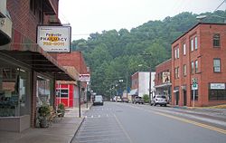
![]() Main Street (West Virginia Route 97) in Pineville in 2007 | |
![]() Location of Pineville in Wyoming County, West Virginia. | |
Coordinates: 37°34′59″N81°32′7″W / 37.58306°N 81.53528°W | |
Country | United States |
State | West Virginia |
County | Wyoming |
Settled | 1853 |
Incorporated | 1907 |
Government | |
• Mayor | Tim Ellison [1] |
Area | |
• Total | 0.81 sq mi (2.10 km2) |
• Land | 0.77 sq mi (1.99 km2) |
• Water | 0.04 sq mi (0.11 km2) |
Elevation | 1,299 ft (396 m) |
Population | |
• Total | 648 |
638 | |
• Density | 747.40/sq mi (288.68/km2) |
Time zone | UTC-5 (Eastern (EST)) |
• Summer (DST) | UTC-4 (EDT) |
ZIP codes | 24859, 24874 |
Area code | 304 |
FIPS code | 54-63940 [4] |
GNIS feature ID | 1544914 [5] |
Website | www |
Pineville is a town in and the county seat [6] of Wyoming County, West Virginia, United States, situated along the Guyandotte River. The population was 648 at the 2020 census. [3]
Pineville was settled by William Short in 1853.
In 1863, Hiram Clay first settled near the site of present Pineville. The community was once called Castlerock, and the post office there was once named Rock Castle. The town was renamed Pineville for the local pine forest and incorporated as a town under that name in 1907. [7] It was named because it was built on the site of a black or pitch pine forest. [8]
Pineville became the county seat in 1907, replacing Oceana after a series of disputed elections. Castle Rock, the towering sandstone formation for which Rockcastle Creek is named, is located at Pineville and is the major local landmark. The Wyoming County Courthouse (1916) is on the National Register of Historic Places. [7]
On April 29, 1960, then Senator John F. Kennedy stopped into Pineville, drawing a crowd of 800. Kennedy spoke briefly over the local radio station WWYO during his time in the town. He then marched with the Pineville High School (West Virginia) band from the radio station to the Wyoming County Courthouse where he spoke to the crowd. [9]
The Pinnacle Drive Inn has operated in Pineville since the late 1950s, and was operated by Carolyn Clay, a well-known native of the town. It closed for a brief period in early 2017, but reopened later that year under new ownership in honor of Clay, and her legacy of service to her community. [10]
Pineville is located at 37°34′59″N81°32′7″W / 37.58306°N 81.53528°W (37.582925, −81.535302). [11] The Guyandotte River flows through Pineville, and collects its tributaries Rockcastle Creek and Pinnacle Creek within the town. [12]
According to the United States Census Bureau, the town has a total area of 0.84 square miles (2.18 km2), of which 0.80 square miles (2.07 km2) is land and 0.04 square miles (0.10 km2) is water. [13]
Many subdivisions or outer areas are considered part of Pineville, including Key Rock, New Richmond, Skin Fork, Mullensville, Glover, Wolf Pen, Rock View, and others, but the town limits are much smaller than the area considered part of Pineville. Unique in the county school system, Pineville's secondary school had no feeder schools. Only after the county's population declined sharply in the 1990s did consolidation and closure of the Glen Rogers High School cause students who attended elementary school outside of Pineville to attend middle or high school in Pineville. Further consolidation ended the town's high school, which was consolidated with Mullens High School to form Wyoming East High School. Students from the catchment areas of the former Herndon, Glen Rogers, Mullens, and Pineville High Schools attend this high school.
Climate data for Pineville, West Virginia (1991–2020 normals, extremes 1908–1910, 1948–2021) | |||||||||||||
---|---|---|---|---|---|---|---|---|---|---|---|---|---|
Month | Jan | Feb | Mar | Apr | May | Jun | Jul | Aug | Sep | Oct | Nov | Dec | Year |
Record high °F (°C) | 79 (26) | 84 (29) | 87 (31) | 92 (33) | 94 (34) | 99 (37) | 101 (38) | 101 (38) | 102 (39) | 96 (36) | 84 (29) | 83 (28) | 102 (39) |
Mean maximum °F (°C) | 63.9 (17.7) | 68.3 (20.2) | 75.3 (24.1) | 85.1 (29.5) | 86.5 (30.3) | 90.0 (32.2) | 91.4 (33.0) | 90.2 (32.3) | 88.0 (31.1) | 80.9 (27.2) | 74.3 (23.5) | 63.7 (17.6) | 92.6 (33.7) |
Mean daily maximum °F (°C) | 41.3 (5.2) | 45.7 (7.6) | 54.8 (12.7) | 67.2 (19.6) | 74.2 (23.4) | 80.6 (27.0) | 83.4 (28.6) | 82.4 (28.0) | 76.8 (24.9) | 66.3 (19.1) | 54.6 (12.6) | 44.4 (6.9) | 64.3 (17.9) |
Daily mean °F (°C) | 32.9 (0.5) | 36.2 (2.3) | 43.4 (6.3) | 54.0 (12.2) | 62.8 (17.1) | 70.4 (21.3) | 73.9 (23.3) | 73.0 (22.8) | 66.7 (19.3) | 55.2 (12.9) | 43.8 (6.6) | 36.2 (2.3) | 54.0 (12.2) |
Mean daily minimum °F (°C) | 24.5 (−4.2) | 26.6 (−3.0) | 32.0 (0.0) | 40.9 (4.9) | 51.3 (10.7) | 60.2 (15.7) | 64.5 (18.1) | 63.7 (17.6) | 56.6 (13.7) | 44.0 (6.7) | 33.0 (0.6) | 28.0 (−2.2) | 43.8 (6.6) |
Mean minimum °F (°C) | 5.7 (−14.6) | 10.2 (−12.1) | 16.6 (−8.6) | 27.7 (−2.4) | 37.0 (2.8) | 49.6 (9.8) | 56.1 (13.4) | 55.6 (13.1) | 43.8 (6.6) | 30.3 (−0.9) | 20.2 (−6.6) | 12.5 (−10.8) | 2.5 (−16.4) |
Record low °F (°C) | −17 (−27) | −16 (−27) | −6 (−21) | 14 (−10) | 25 (−4) | 31 (−1) | 42 (6) | 43 (6) | 32 (0) | 15 (−9) | 4 (−16) | −13 (−25) | −17 (−27) |
Average precipitation inches (mm) | 3.85 (98) | 3.52 (89) | 4.33 (110) | 4.20 (107) | 5.05 (128) | 4.75 (121) | 5.47 (139) | 4.23 (107) | 3.39 (86) | 2.90 (74) | 2.82 (72) | 4.03 (102) | 48.54 (1,233) |
Average snowfall inches (cm) | 9.8 (25) | 4.5 (11) | 2.7 (6.9) | 0.0 (0.0) | 0.0 (0.0) | 0.0 (0.0) | 0.0 (0.0) | 0.0 (0.0) | 0.0 (0.0) | 0.0 (0.0) | 0.4 (1.0) | 2.6 (6.6) | 20.0 (51) |
Average precipitation days (≥ 0.01 in) | 15.0 | 13.4 | 14.7 | 13.9 | 13.7 | 12.8 | 13.5 | 10.8 | 8.9 | 9.3 | 10.9 | 14.4 | 151.3 |
Average snowy days (≥ 0.1 in) | 3.5 | 2.6 | 1.0 | 0.0 | 0.0 | 0.0 | 0.0 | 0.0 | 0.0 | 0.0 | 0.3 | 1.9 | 9.3 |
Source: NOAA [14] [15] |
Census | Pop. | Note | %± |
---|---|---|---|
1910 | 334 | — | |
1920 | 304 | −9.0% | |
1930 | 462 | 52.0% | |
1940 | 769 | 66.5% | |
1950 | 1,082 | 40.7% | |
1960 | 1,137 | 5.1% | |
1970 | 1,187 | 4.4% | |
1980 | 1,140 | −4.0% | |
1990 | 865 | −24.1% | |
2000 | 715 | −17.3% | |
2010 | 668 | −6.6% | |
2020 | 648 | −3.0% | |
2021 (est.) | 638 | [3] | −1.5% |
U.S. Decennial Census [16] |
As of the census [17] of 2010, there were 668 people, 303 households, and 200 families living in the town. The population density was 835.0 inhabitants per square mile (322.4/km2). There were 345 housing units at an average density of 431.3 per square mile (166.5/km2). The racial makeup of the town was 97.8% White, 0.4% African American, 0.4% Asian, and 1.3% from two or more races. Hispanic or Latino of any race were 0.3% of the population.
There were 303 households, of which 24.1% had children under the age of 18 living with them, 50.8% were married couples living together, 10.2% had a female householder with no husband present, 5.0% had a male householder with no wife present, and 34.0% were non-families. 29.4% of all households were made up of individuals, and 15.5% had someone living alone who was 65 years of age or older. The average household size was 2.20 and the average family size was 2.69.
The median age in the town was 49.4 years. 17.4% of residents were under the age of 18; 6.6% were between the ages of 18 and 24; 21% were from 25 to 44; 30.8% were from 45 to 64; and 24% were 65 years of age or older. The gender makeup of the town was 49.6% male and 50.4% female.
As of the census [4] of 2000, there were 715 people, 334 households, and 219 families living in the town. The population density was 908.7 inhabitants per square mile (349.4/km2). There were 377 housing units at an average density of 479.1 per square mile (184.3/km2). The racial makeup of the town was 98.74% White, 0.70% African American, 0.14% Native American, 0.28% Asian, and 0.14% from two or more races. Hispanic or Latino of any race were 0.14% of the population.
There were 334 households, out of which 23.1% had children under the age of 18 living with them, 54.2% were married couples living together, 9.0% had a female householder with no husband present, and 34.4% were non-families. 32.0% of all households were made up of individuals, and 16.8% had someone living alone who was 65 years of age or older. The average household size was 2.14 and the average family size was 2.64.
In the town, the population was spread out, with 17.9% under the age of 18, 7.1% from 18 to 24, 21.3% from 25 to 44, 29.8% from 45 to 64, and 23.9% who were 65 years of age or older. The median age was 47 years. For every 100 females, there were 86.7 males. For every 100 females age 18 and over, there were 83.4 males.
The median income for a household in the town was $31,008, and the median income for a family was $45,000. Males had a median income of $39,688 versus $29,167 for females. The per capita income for the town was $25,184. About 5.2% of families and 10.0% of the population were below the poverty line, including 21.3% of those under age 18 and 7.1% of those age 65 or over.
Lincoln County is a county in the U.S. state of Wyoming. As of the 2020 United States Census, the population was 19,581. Its county seat is Kemmerer. Its western border abuts the eastern borders of the states of Idaho and Utah.
Wyoming County is a county in the U.S. state of West Virginia. As of the 2020 census, the population was 21,382. Its county seat is Pineville. The county was created in 1850 from Logan County and named for the Lenape word meaning "large plains".
Cabell County is a county located in the U.S. state of West Virginia. As of the 2020 census, the population was 94,350, making it West Virginia's fourth most-populous county. Its county seat is Huntington. The county was organized in 1809 and named for William H. Cabell, the Governor of Virginia from 1805 to 1808. Cabell County is part of the Huntington–Ashland, WV–KY–OH Metropolitan Statistical Area.
Pineville is a city in and the county seat of McDonald County, Missouri, United States. The population was 802 at the 2020 census.
Neeses is a town in Orangeburg County, South Carolina, United States. The population was 374 at the 2010 census.
West Hamlin is a town in Lincoln County, West Virginia, United States, along the Guyandotte River. The population was 519 at the 2020 census, and is now down to 509, according to the 2021 census. West Hamlin is a part of the Huntington-Ashland, WV-KY-OH, Metropolitan Statistical Area (MSA). West Hamlin is west of the county seat at Hamlin, hence the name.
Chapmanville is a town in Logan County, West Virginia, United States. The population was 1,025 at the 2020 census. Chapmanville is named for Ned Chapman, an early settler who operated a store and post office. It was incorporated in 1947.
Logan is a city in Logan County, West Virginia, United States, along the Guyandotte River. The population was 1,438 at the 2020 census. It is the county seat of Logan County.
Mallory is a census-designated place (CDP) in Logan County, West Virginia, United States. The population was 1,654 at the 2010 census. The CDP contains the unincorporated communities, from west to east, of Huff Junction, Mallory, Davin, Mineral City, Claypool, Combs Addition, and Gillman Bottom.
Man is a town in Logan County, West Virginia, United States. The population was 772 at the 2020 census. The town is located along the Guyandotte River at the mouth of Buffalo Creek, which was the site of the 1972 Buffalo Creek Flood following a dam collapse. The name of the town reportedly derives from the last syllable of the surname of Ulysses Hinchman, who was a member of the House of Delegates from Logan County between 1866 and 1869.
Mitchell Heights is a town in Logan County, West Virginia, United States. The population was 315 at the 2020 census. The town was named for an early farm on which it was established.
West Logan is a town along the Guyandotte River in Logan County, West Virginia, United States. The population was 400 at the 2020 census. For unknown reasons, some sources report West Logan to lay west of the county seat at Logan, attributing to this fact the name.
Elk Garden is a town in Mineral County, West Virginia, United States. It is part of the 'Cumberland, MD-WV Metropolitan Statistical Area'. The population was 211 at the 2020 census. Elk Garden High School was consolidated into Keyser High School in 1997. However the Primary School is still in session, offering classes from Pre-Kindergarten through the fifth grade. The school mascot is the Elk Garden Stags. Elk Garden was incorporated in 1890 by the Mineral County Circuit Court. It is named for an elk lick near the original town site.
Gilbert is a town in Mingo County, West Virginia, United States, along the Guyandotte River. The population was 333 at the 2020 census. Gilbert was incorporated in 1918 and named for Gilbert Creek, which derives its name from the name of an early traveler in the area who was killed by Native Americans. Gilbert is known nationwide for the Hatfield-McCoy ATV Trails that are located in the area. There are a number of lodges and restaurants in Gilbert.
Mill Creek is a town in Randolph County, West Virginia, United States, along the Tygart Valley River. The population was 563 at the 2020 census.
Mullens is a city in Wyoming County, West Virginia. The population was 1,475 at the time of the 2020 census.
Oceana is a town in Wyoming County, West Virginia. The population was 1,462 at the time of the 2020 census. Oceana is the oldest city in Wyoming County and was the county seat until 1907.
Exeter is a town in Green County, Wisconsin, United States. The population was 1,261 at the 2000 census. The unincorporated communities of Dayton and Ross Crossing are located in the town.
Byron is a town in Big Horn County, Wyoming, United States. The population was 562 according to the 2020 census.
La Valle is a village in Sauk County, Wisconsin, United States, along the Baraboo River. The population was 367 at the 2010 census. The village is located within the Town of La Valle.