War, West Virginia

Last updated

War, West Virginia
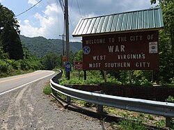
2017-07-22 12 09 09 "Welcome to the City of War" sign along southbound West Virginia State Route 16 (Main Street) at Excelsior A Road (McDowell County Route 102-08) in War, McDowell County, West Virginia.jpg
Nickname: 
West Virginia's most southern city
McDowell County West Virginia Incorporated and Unincorporated areas War Highlighted.svg
Location of War in McDowell County, West Virginia.
USA West Virginia location map.svg
Red pog.svg
War, West Virginia
Location in the State of West Virginia
Coordinates: 37°18′4″N81°41′3″W / 37.30111°N 81.68417°W / 37.30111; -81.68417
Country United States
State West Virginia
County McDowell
Named for War Creek
Government
   Mayor Robert Beavers [1]
Area
[2]
  Total0.92 sq mi (2.38 km2)
  Land0.89 sq mi (2.31 km2)
  Water0.03 sq mi (0.08 km2)
Elevation
1,342 ft (409 m)
Population
 (2020) [3]
  Total690
  Estimate 
(2019) [3]
662
  Density768.80/sq mi (296.85/km2)
Time zone UTC-5 (EST)
  Summer (DST) UTC-4 (EDT)
ZIP code
24892
Area code 304
FIPS code 54-84484 [4]
GNIS feature ID1555916 [5]
Website local.wv.gov/war/Pages/default.aspx

War is a city in McDowell County, West Virginia, United States. The population was 690 at the 2020 census. [3] War was incorporated in 1920 by the Circuit Court of McDowell County. Its name is derived from War Creek, [6] whose confluence with Dry Fork is located within the city. War is the only place in the United States with this name. War was formerly known as Miner's City. It is also known for being a setting in the movie October Sky ; as writer Homer Hickam's Big Creek High School.[ citation needed ]

Contents

Geography

According to the United States Census Bureau, the city has a total area of 0.92 square miles (2.38 km2), of which 0.89 square miles (2.31 km2) is land and 0.03 square miles (0.08 km2) is water. [7]

War had a railway station on the Norfolk Southern Railway (former Norfolk and Western)

Demographics

Historical population
CensusPop.Note
1930 1,392
1940 1,277−8.3%
1950 3,992212.6%
1960 3,006−24.7%
1970 2,004−33.3%
1980 2,1587.7%
1990 417−80.7%
2000 78889.0%
2010 8629.4%
2020 690−20.0%
2021 (est.)662 [3] −4.1%
U.S. Decennial Census [8]

2010 census

As of the census [9] of 2010, there were 862 people, 373 households, and 243 families living in the city. The population density was 968.5 inhabitants per square mile (373.9/km2). There were 436 housing units at an average density of 489.9 per square mile (189.2/km2). The racial makeup of the city was 94.7% White, 3.2% African American, 0.6% Native American, and 1.5% from two or more races. Hispanic or Latino of any race were 0.6% of the population.

There were 373 households, of which 27.6% had children under the age of 18 living with them, 46.1% were married couples living together, 13.4% had a female householder with no husband present, 5.6% had a male householder with no wife present, and 34.9% were non-families. 28.7% of all households were made up of individuals, and 13.5% had someone living alone who was 65 years of age or older. The average household size was 2.31 and the average family size was 2.78.

The median age in the city was 44.7 years. 19.5% of residents were under the age of 18; 6.8% were between the ages of 18 and 24; 23.9% were from 25 to 44; 30.2% were from 45 to 64; and 19.7% were 65 years of age or older. The gender makeup of the city was 49.2% male and 50.8% female.

2000 census

As of the census of 2000, there were 788 people, 331 households, and 225 families living in the city. The population density was 870.6 people per square mile (334.3/km2). There were 388 housing units at an average density of 428.7 per square mile (164.6/km2). The racial makeup of the city was 94.67% White, 4.57% African American, 0.25% Native American, 0.38% from other races, and 0.13% from two or more races. Hispanic or Latino of any race were 0.63% of the population.

There were 331 households, out of which 28.7% had children under the age of 18 living with them, 50.5% were married couples living together, 14.8% had a female householder with no husband present, and 32.0% were non-families. 29.3% of all households were made up of individuals, and 13.0% had someone living alone who was 65 years of age or older. The average household size was 2.38 and the average family size was 2.93.

In the city, the population was spread out, with 24.5% under the age of 18, 5.5% from 18 to 24, 26.1% from 25 to 44, 27.7% from 45 to 64, and 16.2% who were 65 years of age or older. The median age was 41 years. For every 100 females, there were 86.7 males. For every 100 females age 18 and over, there were 83.1 males.

The median income for a household in the city was $16,012, and the median income for a family was $20,521. Males had a median income of $32,500 versus $18,438 for females. The per capita income for the city was $9,285. About 34.8% of families and 43.3% of the population were below the poverty line, including 66.5% of those under age 18 and 15.1% of those age 65 or over.
See also

Related Research Articles

<span class="mw-page-title-main">Madison, West Virginia</span> City in West Virginia, United States

Madison is a city and former coal town in Boone County, West Virginia, United States. The population was 2,911 at the 2020 census. It is the county seat of Boone County.

<span class="mw-page-title-main">Burnsville, West Virginia</span> Town in West Virginia, United States

Burnsville is a town in Braxton County, West Virginia, United States, at the confluence of the Little Kanawha River and Saltlick Creek. The population was 401 at the 2020 census. Burnsville was incorporated in 1902 by the Circuit Court and named for Captain John Burns who operated the first sawmill in that section of the state and who established the town shortly after the close of the American Civil War. It was named "All West Virginia City" in 1976.

<span class="mw-page-title-main">Follansbee, West Virginia</span> City in West Virginia, United States

Follansbee is a city in Brooke County, West Virginia, United States, located along the Ohio River. The population was 2,853 at the 2020 census, a decrease from 2,986 at the 2010 census. It is part of the Weirton–Steubenville metropolitan area. The city was named after the Follansbee brothers, the proprietors of a local steel mill.

<span class="mw-page-title-main">Windsor Heights, West Virginia</span> Village in West Virginia, United States

Windsor Heights is a village in Brooke County, West Virginia, United States. It is part of the Wheeling, West Virginia Metropolitan Statistical Area. The population was 423 at the 2010 census. Grace Davis was the mayor as of June, 2017.

<span class="mw-page-title-main">Stonewood, West Virginia</span> City in West Virginia, United States

Stonewood is a city in Harrison County, West Virginia, United States. The population was 1,810 at the 2020 census.

<span class="mw-page-title-main">Fairview, West Virginia</span> Town in West Virginia, United States

Fairview is a town in Marion County, West Virginia, United States. The population was 374 at the 2020 census.

<span class="mw-page-title-main">Glen Dale, West Virginia</span> Town in West Virginia

Glen Dale is a city in Marshall County, West Virginia, United States, along the Ohio River. It is part of the Wheeling, West Virginia Metropolitan Statistical Area. The population was 1,514 at the 2020 census. Glen Dale was incorporated in 1924. It is in the northwest part of the county, which is above the Mason–Dixon line and forms the base of the Northern Panhandle of West Virginia.

<span class="mw-page-title-main">McMechen, West Virginia</span> City in West Virginia

McMechen is a city in Marshall County, West Virginia, United States, situated along the Ohio River. It is part of the Wheeling, West Virginia Metropolitan Statistical Area. The population was 1,714 at the 2020 census.

<span class="mw-page-title-main">New Haven, West Virginia</span> Town in West Virginia, United States

New Haven is a town in Mason County, West Virginia, United States, along the Ohio River. The population was 1,485 at the 2020 census. It is part of the Point Pleasant, WV–OH Micropolitan Statistical Area.

<span class="mw-page-title-main">Davy, West Virginia</span> Town in West Virginia, United States

Davy is a town in McDowell County, West Virginia, United States. The population was 420 at the 2010 census. Founded in 1873, the town was originally called Hallsville but the name would change to Davy by 1901. Davy was officially incorporated in 1948. It is a mostly residential community in a coal mining district along the main line of the Norfolk Southern Railway.

<span class="mw-page-title-main">Belmont, West Virginia</span> Town in West Virginia, United States

Belmont is a town in Pleasants County, West Virginia, United States. It is part of the Parkersburg–Vienna metropolitan area. The population was 872 at the 2020 census. Belmont was incorporated on April 19, 1946 by the Circuit Court of Pleasants County. The city was named for the beautiful hills in the area.

<span class="mw-page-title-main">Sophia, West Virginia</span> Town in West Virginia, United States

Sophia is a town in Raleigh County, West Virginia, United States. It was incorporated in 1912. The population was 1,124 at the 2020 census.

<span class="mw-page-title-main">Cairo, West Virginia</span> Town in West Virginia, United States

Cairo is a town in Ritchie County, West Virginia, United States, along West Virginia Route 31, the North Fork of the Hughes River, and the North Bend Rail Trail. The population was 174 at the 2020 census.

<span class="mw-page-title-main">Ellenboro, West Virginia</span> Town in West Virginia, United States

Ellenboro is a town in Ritchie County, West Virginia, United States. The population was 222 at the 2020 census. The town is located at the junction of U.S. Route 50 and West Virginia Route 16; the North Bend Rail Trail also passes through the town. The town was named for Ellen Mariah Williamson, the eldest daughter of the family that granted a right of way for the Baltimore and Ohio Railroad to build their line through the town; an earlier name for the community was Shumley. Ellenboro was incorporated in 1903.

<span class="mw-page-title-main">Pennsboro, West Virginia</span> City in West Virginia, United States

Pennsboro is a city in Ritchie County, West Virginia, United States. The population was 1,050 at the 2020 census. The city is located at the junction of U.S. Route 50 and West Virginia Route 74; the North Bend Rail Trail also passes through the city.

<span class="mw-page-title-main">Reedy, West Virginia</span> Town in West Virginia, United States

Reedy is a town in Roane County, West Virginia, United States. The population was 152 at the 2020 census.

<span class="mw-page-title-main">Camden-on-Gauley, West Virginia</span> Town in West Virginia, United States

Camden-on-Gauley is a town in Webster County, West Virginia, United States, along the Gauley River. The population was 126 at the 2020 census.

<span class="mw-page-title-main">Pine Grove, West Virginia</span> Town in West Virginia, United States

Pine Grove is a town in Wetzel County, West Virginia, United States. The population was 363 at the 2020 census. The community was named for a grove of pine trees near the original town site.

<span class="mw-page-title-main">North Hills, West Virginia</span> Town in West Virginia, United States

North Hills is a town in Wood County, West Virginia, United States. It is a suburb of Parkersburg. The population was 837 at the 2020 census. North Hills was incorporated on February 15, 1979.

<span class="mw-page-title-main">Vienna, West Virginia</span> City in West Virginia, United States

Vienna is a city in Wood County, West Virginia, United States, situated along the Ohio River. The population was 10,676 at the 2020 census. It is the second-largest city in the Parkersburg–Vienna metropolitan area.

References

  1. "Archived copy" (PDF). www.regiononepdc.org. Archived from the original (PDF) on September 27, 2006. Retrieved January 17, 2022.{{cite web}}: CS1 maint: archived copy as title (link)
  2. "2019 U.S. Gazetteer Files". United States Census Bureau. Retrieved August 7, 2020.
  3. 1 2 3 4 "City and Town Population Totals: 2020-2021". Census.gov. US Census Bureau. Retrieved July 3, 2022.
  4. "U.S. Census website". United States Census Bureau . Retrieved January 31, 2008.
  5. U.S. Geological Survey Geographic Names Information System: War, West Virginia
  6. Capace, Nancy (1999). Encyclopedia of West Virginia. North American Book Dist LLC. p. 195. ISBN   978-0-403-09843-9.
  7. "US Gazetteer files 2010". United States Census Bureau . Retrieved January 24, 2013.
  8. "U.S. Decennial Census". Census.gov. Retrieved June 11, 2013.
  9. "U.S. Census website". United States Census Bureau . Retrieved January 24, 2013.