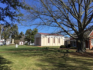
Gloucester County is a county in the Commonwealth of Virginia. As of the 2010 census, the population was 36,858. Its county seat is Gloucester Courthouse. The county was founded in 1651 in the Virginia Colony and is named for Henry Stuart, Duke of Gloucester.

York County is a county in the eastern part of the Commonwealth of Virginia, located in the Tidewater. As of the 2010 census, the population was 65,464. The county seat is the unincorporated town of Yorktown.

Powhatan County is a county located in the Commonwealth of Virginia. As of the 2010 census, the population was 28,046. Its county seat is Powhatan.

Pocahontas was a Native American woman notable for her association with the colonial settlement at Jamestown, Virginia. She was the daughter of Powhatan, the paramount chief of a network of tributary tribes in the Tsenacommacah, encompassing the Tidewater region of Virginia. She saved the life of Colonist John Smith in 1607, who was being held captive by her tribe, by placing her head upon Smith's when her father raised his war club to execute him.

The Powhatan people are an Indigenous group traditionally from Virginia. In some instances, The Powhatan may refer to one of the leaders of the people. This is most commonly the case in historical writings by the English. The Powhatans have also been known as Virginia Algonquians, as the Powhatan language is an eastern-Algonquian language, also known as Virginia Algonquian. It is estimated that there were about 14,000–21,000 Powhatan people in eastern Virginia, when the English colonized Jamestown in 1607.

Powhatan, whose proper name was Wahunsenacawh, was the paramount chief of Tsenacommacah, an alliance of Algonquian-speaking Virginia Indians in the Tidewater region of Virginia at the time English settlers landed at Jamestown in 1607.
Weroance is an Algonquian word meaning leader or commander among the Powhatan confederacy of the Virginia coast and Chesapeake Bay region. Weroances were under a paramount chief called Powhatan. The Powhatan Confederacy, encountered by the colonists of Jamestown and adjacent area of the Virginia Colony beginning in 1607, spoke an Algonquian language. Each tribe of the Powhatan Confederacy was led by its own weroance. Most foreign writers who have come across a weroance only did so on a special occasion. This is the case because a foreigners presence was special. John Smith noted that there are few differences between weroances and their subjects.

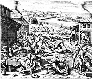
The Indian massacre of 1622 took place in the English Colony of Virginia, in what is now the United States, on Friday, 22 March 1622. John Smith, though he had not been in Virginia since 1609 and was not an eyewitness, related in his History of Virginia that braves of the Powhatan "came unarmed into our houses with deer, turkeys, fish, fruits, and other provisions to sell us". The Powhatan grabbed any tools or weapons available and killed all the English settlers they found, including men, women, and children of all ages. Chief Opechancanough led the Powhatan Confederacy in a coordinated series of surprise attacks; they killed 347 people, a quarter of the population of the Virginia colony.

Werowocomoco was a village that served as the headquarters of the Powhatan, a Virginia Algonquian political and spiritual leader when the English founded Jamestown in 1607. The name Werowocomoco comes from the Powhatan werowans (weroance), meaning "leader" in English; and komakah (-comoco), "settlement". The town was documented by English settlers in 1608 as located near the north bank of the York River in what is now Gloucester County. It was separated by that river and the narrow Virginia Peninsula from the English settlement of Jamestown, located on the James River.

The Native American tribes in Virginia are the indigenous tribes who currently live or have historically lived in what is now the Commonwealth of Virginia in the United States of America.

Ballsville is an unincorporated community in Powhatan County, Virginia. The community is located approximately forty miles due west of Richmond. It is on Virginia State Route 13 between Powhatan, Virginia and Cumberland, Virginia.

The Anglo–Powhatan Wars were three wars fought between English settlers of the Virginia Colony, and Algonquin of the Powhatan Confederacy in the early seventeenth century. The First War started in 1610, and ended in a peace settlement in 1614. Another war between the two powers lasted from 1622 to 1626. The third war lasted from 1644 until 1646, and ended when Opechancanough was captured and killed. That war resulted in a boundary being defined between the Indians and English lands that could only be crossed for official business with a special pass. This situation would last until 1677 and the Treaty of Middle Plantation, which established Indian reservations following Bacon's Rebellion.
Totopotomoi was an Wyanoke Native American leader from what is now Virginia. He served as the chief of Pamunkey and as werowance of the Powhatan Confederacy for the term lasting from 1646 until 1657, when he died in the Battle of Bloody Run.

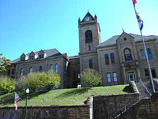
Powhatan is a census-designated place in and the county seat of Powhatan County, Virginia, United States. Powhatan was initially known as Scottville for a brief time, and historically has also been known as Powhatan Court House and Powhatan Courthouse. Powhatan is named after Chief Powhatan, father of Pocahontas.

The East End of Richmond, Virginia is the quadrant of the City of Richmond, Virginia, and more loosely the Richmond metropolitan area, east of the downtown.
Goode Crossing is an unincorporated community in Powhatan County, in the U.S. state of Virginia.
Macon is an unincorporated community in Powhatan County, in the U.S. state of Virginia. Macon was a stop on the Farmville and Powhatan Railroad from 1884 to 1905 and then on the Tidewater and Western Railroad from 1905 to 1917. It is on the new Virginia State Route 13 between Powhatan, Virginia and Cumberland, Virginia from 1918 to today.

Tobaccoville is an unincorporated community in Powhatan County, Virginia. Tobaccoville was a stop on the Farmville and Powhatan Railroad from 1884 to 1905 and then on the Tidewater and Western Railroad from 1905 to 1917. A magazine notice for renting the "Indian Camp" farm advertised that the farm was near the Tobaccoville station of the Tidewater and Western Railroad. This would help the tenant farmer get dairy products to market.
Sunny Side is an unincorporated community in Buckingham and Cumberland counties, in the U.S. state of Virginia. Sunny Side was a stop on the Farmville and Powhatan Railroad from 1884 to 1905 and then on the Tidewater and Western Railroad from 1905 to 1917. It is on the new Virginia State Route 13 between Powhatan, Virginia and Cumberland, Virginia from 1918 to today.
Powhatan Shores is an unincorporated community in Gloucester County, in the U. S. state of Virginia.


