McDowell | |
---|---|
Unincorporated community | |
Coordinates: 37°24′10″N81°22′49″W / 37.40278°N 81.38028°W Coordinates: 37°24′10″N81°22′49″W / 37.40278°N 81.38028°W | |
Country | United States |
State | West Virginia |
County | McDowell |
Elevation | 1,965 ft (599 m) |
Time zone | Eastern (EST) (UTC-5) |
• Summer (DST) | EDT (UTC-4) |
Area code(s) | 304 & 681 |
GNIS feature ID | 1555083 [1] |
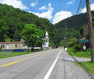
McDowell is an unincorporated community in McDowell County, West Virginia, United States. McDowell is 3.5 miles (5.6 km) east-southeast of Northfork.
In law, an unincorporated area is a region of land that is not governed by a local municipal corporation; similarly an unincorporated community is a settlement that is not governed by its own local municipal corporation, but rather is administered as part of larger administrative divisions, such as a township, parish, borough, county, city, canton, state, province or country. Occasionally, municipalities dissolve or disincorporate, which may happen if they become fiscally insolvent, and services become the responsibility of a higher administration. Widespread unincorporated communities and areas are a distinguishing feature of the United States and Canada. In most other countries of the world, there are either no unincorporated areas at all, or these are very rare; typically remote, outlying, sparsely populated or uninhabited areas.
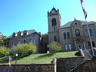
McDowell County is a county in the U.S. state of West Virginia. As of the 2010 census, the population was 22,113. Its county seat is Welch. McDowell county is the southernmost county in the state. It was created in 1858 by the Virginia General Assembly and named for Virginia Governor James McDowell. It became a part of West Virginia in 1863, when several counties seceded from the state of Virginia during the American Civil War.
West Virginia is a state located in the Appalachian region in the Southern United States that is also considered to be a part of the Middle Atlantic States. It is bordered by Pennsylvania to the north, Maryland to the east and northeast, Virginia to the southeast, Kentucky to the southwest, and Ohio to the northwest. West Virginia is the 41st largest state by area, and is ranked 38th in population. The capital and largest city is Charleston.
The community most likely was named after the local McDowell Coal and Coke Company. [2]
Rockridge is an unincorporated community in McDowell County, West Virginia. It was originally named Collins Ridge on account of a large shared of the first settlers having the surname Collins. The present name is for the rocky soil near the original town site.
Capels is an unincorporated community on the Tug Fork River in McDowell County, West Virginia, United States.
Ennis is an unincorporated community in McDowell County, West Virginia, United States. Ennis lies on U.S. Route 52 west of Switchback.
Gilliam is an unincorporated community on the North Fork River in McDowell County, West Virginia, United States. It lies between Algoma and Rolfe along County Route 17.
Isaban is an unincorporated community located on Fourpole Creek, in McDowell and Mingo counties in the U.S. state of West Virginia.
Mohegan is an unincorporated community on the Tug Fork River in McDowell County, West Virginia, United States. It sits at an altitude of 1,230 feet.
Powhatan is an unincorporated community in McDowell County, West Virginia located approximately one mile from Northfork, West Virginia.
Panther is an unincorporated community in McDowell County, West Virginia, United States. Panther is located along the Tug Fork 4.5 miles (7.2 km) west-northwest of Iaeger. Panther has a post office with ZIP code 24872.
Premier is an unincorporated community in McDowell County, West Virginia, United States. Premier is located along U.S. Route 52 3.5 miles (5.6 km) west-southwest of Welch. Premier has a post office with ZIP code 24878.
Squire is an unincorporated community in McDowell County, West Virginia, United States. Squire is located on West Virginia Route 16 6.5 miles (10.5 km) southeast of War. Squire has a post office with ZIP code 24884.
Six is an unincorporated community in McDowell County, West Virginia, United States. Six is located on West Virginia Route 16 5 miles (8.0 km) southwest of Welch.
Superior is an unincorporated community in McDowell County, West Virginia, United States. Superior is located on U.S. Route 52 2.5 miles (4.0 km) east-southeast of Welch.
Leckie is an unincorporated community in McDowell County, West Virginia, United States. Leckie is 1 mile (1.6 km) northeast of Anawalt.
Twin Branch is an unincorporated community in McDowell County, West Virginia, United States. Twin Branch is 1 mile (1.6 km) west-southwest of Davy. It was founded by Henry Ford as a mining community.
Vallscreek is an unincorporated community in McDowell County, West Virginia, United States. Vallscreek is 5.5 miles (8.9 km) south-southeast of War. It was also known as Hartwell.
Worth is an unincorporated community in McDowell County, West Virginia, United States. Worth is 3 miles (4.8 km) east of Northfork.
Monson is an unincorporated community in McDowell County, West Virginia, United States. Monson is located along West Virginia Route 161 5.5 miles (8.9 km) south-southwest of Anawalt.
Lex is an unincorporated community in McDowell County, West Virginia, United States. Lex is located on West Virginia Route 80 1.3 miles (2.1 km) north of Bradshaw.
Litwar is an unincorporated community in McDowell County, West Virginia, United States. Litwar is located on the Tug Fork 2 miles (3.2 km) west-northwest of Iaeger.
This article about a location in McDowell County, West Virginia is a stub. You can help Wikipedia by expanding it. |