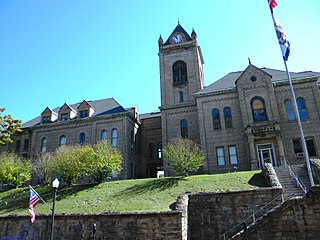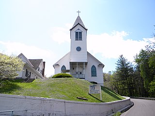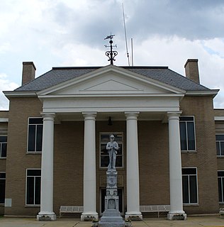
McDowell County is a county in the U.S. state of West Virginia. As of the 2020 census, the population was 19,111. Its county seat is Welch. McDowell County is the southernmost county in the state. It was created in 1858 by the Virginia General Assembly and named for Virginia Governor James McDowell. It became a part of West Virginia in 1863, when several Union-affiliated counties seceded from the state of Virginia during the American Civil War. McDowell Country is located in the Cumberland Mountains, part of the Appalachia region.

Pike County is a county in the U.S. state of Kentucky. As of the 2020 census, the population was 58,669. Its county seat is Pikeville. The county was founded in 1821. With regard to the sale of alcohol, it is classified as a moist county—a county in which alcohol sales are prohibited, but containing a "wet" city. There are three cities, Pikeville, Elkhorn City, and Coal Run Village, in the county where package alcohol sales are allowed.

Marion is a city in McDowell County, North Carolina, United States. It is the county seat of McDowell County. Founded in 1844, the city was named in honor of Brigadier General Francis Marion, the American Revolutionary War Hero whose talent in guerrilla warfare earned him the name "Swamp Fox". Marion's Main Street Historic District is listed on the National Register of Historic Places. The population was 7,717 at the 2020 Census.

Uniontown is a city in Fayette County, Pennsylvania, United States, 46 miles (74 km) southeast of Pittsburgh and part of the Greater Pittsburgh Region. The population was 10,372 at the 2010 census, down from 12,422 at the 2000 census. It is the county seat and largest city of Fayette County.

Thurmond is a town in Fayette County, West Virginia, United States, on the New River. The population was five at the 2020 census. During the heyday of coal mining in the New River Gorge, Thurmond was a prosperous town with a number of businesses and facilities for the Chesapeake and Ohio Railway.

Shinnston is a city and former coal town in Harrison County, West Virginia, United States, along the West Fork River. In 1778, Levi Shinn constructed his log home along what is now Route 19; today it is the oldest standing structure in north-central West Virginia. As of the 2020 census, Shinnston had a population of 2,332.

Alum Creek is a census-designated place (CDP) in Kanawha and Lincoln counties along the Coal River in the U.S. state of West Virginia. It includes the unincorporated communities of Alum Creek, Forks of Coal, and Priestley. The CDP had a population of 1,749 at the 2010 census, down from 1,839 at the 2000 census.

Gary is a city located along the Tug Fork River in McDowell County, West Virginia, United States. According to the 2020 census, the city had a population of 762. It was named for Elbert Henry Gary, one of the founders of U.S. Steel. The former coal towns of Elbert, Filbert, Thorpe, and Wilcoe became part of Gary at the time of its incorporation in 1971.

Welch is a city located in McDowell County in the State of West Virginia, United States. The population was 3,590 at the 2020 census, though a 2021 census estimate put the population at 1,914, likely due to changes in city boundary lines. Incorporated as a city in 1893, it is the county seat of McDowell County.

Princeton, is a city in and the county seat of Mercer County, West Virginia, United States. The city is coined the "Heart of Mercer County" or the "Jewel of the South" in past decades. The population was 6,432 at the 2010 census with approximately 35,000 residents living in the greater Princeton area. It is part of the Bluefield, WV-VA micropolitan area which has a population of 107,342. The city hosts the Princeton WhistlePigs baseball club of the Appalachian League. A main tourist destination of the city is the Mercer Street Grassroots District located in Downtown Princeton. This area has been revitalized and is now home to cafes, restaurants, shops, and artistic venues.

Grafton is a city in and the county seat of Taylor County, West Virginia, United States. The population was 4,729 at the 2020 census. It originally developed as a junction point for the Baltimore and Ohio Railroad, serving numerous branches of a network that was vital to the regional coal industry.

Parsons is the county seat and largest city in Tucker County, West Virginia, United States. The population was 1,322 at the 2020 census. The mayor of Parsons is Dorothy Judy and the city administrator is Jason Myers. The city is also governed by a city council.

Thomas is a city and former coal town in Tucker County, West Virginia, United States. The population was 623 at the 2020 census.

Tazewell County is a county located in the southwestern portion of the U.S. state of Virginia. As of the 2010 census, the population was 40,429. Its county seat is Tazewell.
Pageton is a census-designated place (CDP) in McDowell County, West Virginia, United States. As of the 2010 census, its population was 187. Pageton is located on the Tug Fork Branch of the Norfolk and Western Railway, along the Pocahontas seam of rich bituminous coal. Pageton is located on State Route 161 between Thorpe and Anawalt.

Pocahontas Coalfield, which is also known as the Flat Top-Pocahontas Coalfield, is located in Mercer County/McDowell County, West Virginia and Tazewell County, Virginia. The earliest mining of coal in the coalfield was in Pocahontas, Virginia in 1883 at Pocahontas Mine No. 1, now on the National Register of Historic Places.
Vivian is a census-designated place (CDP) in McDowell County, West Virginia, United States. Vivian is located along U.S. Route 52, 1 mile (1.6 km) southeast of Kimball. As of the 2010 census, its population was 82.

Pocahontas Fuel Company Store, also known as Norfolk Coal & Coke Company Store and Henderson Market, was a historic Pocahontas Fuel Company company store building located at Maybeury, McDowell County, West Virginia. It was built before 1903, and was a one- to two-story wood-frame building on a stone foundation. It featured a pyramidal roof in one corner.

Pocahontas Fuel Company operated mines in the state of Virginia in Boissevain and Amonate, and in West Virginia at Jenkinjones, Bishop, and Itmann. Pocahontas Fuel Company founded the Pocahontas Consolidated Collieries Company in 1907. In 1956 Pocahontas was acquired by the Consolidation Coal Company. Consolidation Coal Company became Consol Energy in 1991. Consol Energy mines coal at Amonate. Pocahontas Fuel Company used the Norfolk & Western Railway bring the coal to ports for shipment.


