Yerba Buena Island sits in the San Francisco Bay between San Francisco and Oakland, California. The Yerba Buena Tunnel runs through its center and connects the western and eastern spans of the San Francisco–Oakland Bay Bridge. It has had several other names over the decades: Sea Bird Island, Wood Island, and Goat Island. The island is named after the town of Yerba Buena, which was named for the plant of the same name that was abundant in the area. The plant's English and Spanish common name, Yerba buena, is an alternate form of the Spanish hierba buena, generally used to describe local species of the mint family.

Yerba mate is a species of the holly genus (Ilex), with the botanical name Ilex paraguariensis A. St.-Hil., named by the French botanist Auguste François César Prouvençal de Saint-Hilaire.

The San Francisco–Oakland Bay Bridge, known locally as the Bay Bridge, is a complex of bridges spanning San Francisco Bay in California. As part of Interstate 80 and the direct road between San Francisco and Oakland, it carries about 260,000 vehicles a day on its two decks. It has one of the longest spans in the United States.

Yerba Buena Gardens is the name for two blocks of public parks located between Third and Fourth, Mission and Folsom Streets in downtown San Francisco, California. The first block bordered by Mission and Howard Streets was opened on October 11, 1993. The second block, between Howard and Folsom Streets, was opened in 1998, with a dedication to Martin Luther King, Jr. by Mayor Willie Brown. A pedestrian bridge over Howard Street connects the two blocks, sitting on top of part of the Moscone Center convention center. The Yerba Buena Gardens are owned by the San Francisco Redevelopment Agency and were planned and built as the final centerpiece of the Yerba Buena Redevelopment Area which includes the Yerba Buena Center for the Arts.

The Financial District is a neighborhood in San Francisco, California, that serves as its main central business district. It is home to the city's largest concentration of corporate headquarters, law firms, insurance companies, real estate firms, savings and loan banks, and other financial institutions. All six San Francisco Fortune 500 companies—McKesson, Wells Fargo, PG&E, Gap, Charles Schwab, and Salesforce.com— are located in the district.

Yerba Buena High School is a public, comprehensive four-year high school located in the East San Jose area of San Jose, California, USA. Its athletic teams are well-known, and the school has the Engineering MAGNET program and the Green Construction/Architecture MAGNET program.
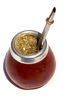
Mate, also known as chimarrão or cimarrón, is a traditional South American caffeine-rich infused drink, that was first consumed by the Guaraní and also spread by the Tupí people. In the last centuries, it became particularly popular in Argentina and Uruguay, as also in Paraguay, the Bolivian Chaco, Southern Chile and Southern Brazil. It is also consumed in Syria, the largest importer in the world, and in Lebanon.
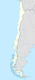
Yerbas Buenas is a Chilean town and commune in Linares Province, Maule Region. It lies in the geographical center of the country, on the fertile central plain, some 300 km (186 mi) south of the national capital of Santiago, 50 km (31 mi) south of Talca, the regional capital and 12 km (7 mi) north of Linares, the provincial capital.

Yerba Buena Lighthouse is a lighthouse in California, United States, in the San Francisco Bay on Yerba Buena Island, California
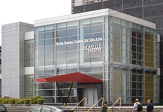
Yerba Buena Center for the Arts (YBCA) is a multi-disciplinary contemporary arts center in San Francisco, California, United States. Located in Yerba Buena Gardens, YBCA features visual art, performance, and film/video that celebrates local, national, and international artists and the Bay Area's diverse communities. YBCA programs year-round in two landmark buildings—the Galleries and Forum by Japanese architect Fumihiko Maki and Theater by American architect James Stewart Polshek and Todd Schliemann. Betti-Sue Hertz served as Curator from 2008 through 2015.

The monotypic genus Anemopsis has only one species, Anemopsis californica, with the common names yerba mansa or lizard tail.

Yerba Buena was the original name of the settlement that later became San Francisco, California. Located near the northeastern end of the San Francisco Peninsula, between the Presidio of San Francisco and the Mission San Francisco de Asís, it was originally intended as a trading post for ships visiting San Francisco Bay. The settlement was arranged in the Spanish style around a plaza that remains as the present day Portsmouth Square.
Magdalena Solís, also known as the High Priestess of Blood, was a serial killer and member of a Mexican cult responsible for orchestrating several murders which involved the drinking of the victims' blood. She was convicted of two of the murders and sentenced to 50 years in prison.
Events from the year 1822 in the United States.

The Yerba Buena Tunnel, also known as the Yerba Buena Island Tunnel, is a highway tunnel in San Francisco, California. It is the part of San Francisco–Oakland Bay Bridge complex that crosses Yerba Buena Island. The Yerba Buena Tunnel carries ten lanes of Interstate 80 (I-80) on two decks, connecting the two component spans of the Bay Bridge, the western suspension span and the eastern self-anchored suspension span. At the opening of the Bay Bridge in 1936, it was the world's largest-bore tunnel.

Yerba Buena Cove was a cove on San Francisco Bay where the Mexican pueblo of Yerba Buena was located. It lay between Clarks Point to the north and Rincon Point to the south. The beach of the cove was set back as far as what is now Montgomery Street between Clay and Washington Streets. Between the beginning of the California Gold Rush and 1860 the cove was filled in, and the downtown of the city of San Francisco built over it. A number of ships were sunk in the cove, some intentionally scuttled to allow the owners to claim the land around the sunken ship. Wrecks known to remain buried include the Apollo, the Niantic, and the Rome, the latter of which was discovered in 1994 during construction of the Muni Metro Turnback Tunnel.
Baccharis pteronioides is a North American shrub in the aster family known by the common name Yerba de pasmo. It is widespread in Mexico and also found in the southwestern United States.