State Route 127 is a primary state highway in the U.S. state of Virginia. The state highway begins at the West Virginia state line at Good, West Virginia, where the highway continues west as West Virginia Route 127. SR 127 heads east 3.55 miles (5.71 km) to U.S. Route 522 near Cross Junction in northwestern Frederick County. SR 127 is the easternmost portion of Bloomery Pike, a turnpike that connected Winchester with the namesake iron smelting center.
West Virginia Route 971 is a 9.9-mile (15.9 km) north–south state highway in Wyoming County, West Virginia. The route runs from West Virginia Route 97 in Baileysville north to West Virginia Route 10 in Oceana. It runs through mountainous, rural terrain, connecting Baileysville and Oceana to the communities of Clear Fork, Lillydale, and Lillyhaven.

Seneca Creek is a 19.6-mile-long (31.5 km) tributary of the North Fork of the South Branch of the Potomac River located entirely within Pendleton County, West Virginia, USA.
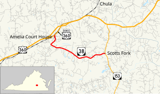
State Route 38 is a primary state highway in the U.S. state of Virginia. Known for most of its length as Five Forks Road, the state highway runs 7.03 miles (11.31 km) from U.S. Route 360 Business in Amelia Court House east to SR 153 at Scotts Fork.
Clear Fork may refer to a location in the United States:

Back Allegheny Mountain is a long mountain ridge in eastern West Virginia. It is part of the Shavers Fork Mountain Complex in the Allegheny Range of the Appalachians.

Clear Fork is an unincorporated community in Wyoming County, West Virginia, United States, along the Clear Fork.

Lillydale is an unincorporated community in Wyoming County, West Virginia, United States. Lillydale is located on West Virginia Route 971 along the Clear Fork, 2.5 miles (4.0 km) southwest of Oceana.

Artie is an unincorporated community in Raleigh County, West Virginia, United States. Artie is 5.5 miles (8.9 km) west-northwest of Pax. Artie had a post office, which opened on October 5, 1903, and closed on February 1, 1997.
Cohasset is an unincorporated community in Fluvanna County, in the U.S. state of Virginia located about two miles west of Fork Union on State Route 6.
Judy Gap is an unincorporated community in Pendleton County, West Virginia, United States. Judy Gap is located at the junction of U.S. Route 33 and West Virginia Route 28 8.5 miles (13.7 km) west-northwest of Franklin, just west of the mountain gap also called Judy Gap. The Judy Rocks geological formation is just to the south. North Fork Mountain is to the east, and the North Fork of the South Branch of the Potomac River is to the west, with Spruce Mountain and Spruce Knob beyond the river. Most of the surrounding land is within the Monongahela National Forest.
Liverpool is an unincorporated community in Jackson and Roane counties, West Virginia, United States. Liverpool is located along the Right Fork Sandy Creek at the junction of Jackson County Route 13 and Roane County Route 1, 5.7 miles (9.2 km) west of Reedy Liverpool had a post office, which closed on May 30, 1989. The community was named after Liverpool, in England.
Crany is an unincorporated community in Wyoming County, West Virginia, along the Clear Fork.
Fork Junction is an unincorporated community in Lincoln County, West Virginia, United States.

The Clear Fork is a tributary of the Guyandotte River, 29 miles (47 km) long, in southern West Virginia in the United States. Via the Guyandotte and Ohio rivers, it is part of the watershed of the Mississippi River, draining an area of 129 square miles (330 km2) in a rural area on the unglaciated portion of the Allegheny Plateau. The Clear Fork flows for its entire length in Wyoming County; its tributary the Laurel Fork also drains a small area of western Raleigh County.
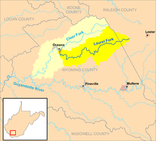
The Laurel Fork is a tributary of the Clear Fork, 23.5 miles (37.8 km) long, in southern West Virginia in the United States. Via the Clear Fork and the Guyandotte and Ohio rivers, it is part of the watershed of the Mississippi River, draining an area of 56.4 square miles (146 km2) in a rural area on the unglaciated portion of the Allegheny Plateau.
Toney Fork is an unincorporated community in Wyoming County, West Virginia, United States. Toney Fork is located on West Virginia Route 85 at the confluence of the Clear Fork and the Toney Fork, 2 miles (3.2 km) northeast of Oceana.

Forks of Waters is an unincorporated community located in Highland County, Virginia, United States. Forks of Waters is located approximately 6 miles (9.7 km) northeast of Monterey, Virginia at the junction of U.S. Route 220 and Virginia State Route 642. Forks of Waters is so named due to the convergence of the Strait Creek with the South Branch Potomac River near the community. After passing through Forks of Waters, the South Branch Potomac River enters West Virginia approximately 1 mile (1.6 km) to the northeast.