As early as 1772, settlers began claiming lands near where Clarksburg now stands and building cabins. In 1773, Major Daniel Davisson (1748–1819) took up 400 acres (1.6km2), upon which the principal part of the town is now located. By 1774, those settling near present Clarksburg included Daniel, Obadiah, and Amaziah Davisson, Thomas, John, and Matthew Nutter, Samuel and Andrew Cottrill, Sotha Hickman, and Samuel Beard. Others likely settled on public lands without record.[6]
The Virginia General Assembly authorized the town of Clarksburg in 1785. It is named for George Rogers Clark, a Virginian whose Revolutionary War campaigns included the capture of Vincennes in 1778.[8] In 1786, the Assembly authorized a road from Winchester, Virginia to Morgantown that later tied into what became the Northwestern Turnpike. In 1787, it chartered the Randolph Academy at Clarksburg, a private school led by Rev. George Towers and the first west of the Alleghenies.[9]
Construction of the first Harrison County courthouse began in 1787. Four larger courthouses followed, the most recent completed in 1932. The first stood at the northeast corner of Second and Main Streets, with the jail opposite on Main Street.[9]
Two notable early landmarks survive from this era: the Stealey–Goff–Vance House (1807, expanded 1891, NRHP 1979) and Waldomore (begun 1839, public library 1931–1976, NRHP 1978).[9]
Union General McClellan established his headquarters near Clarksburg until the First Battle of Bull Run. The B&O line made the city an important Union supply base, with more than 7,000 troops at one point. Confederate raiders struck the region but did not take the city. The Jones–Imboden Raid of April and May 1863 sought to impede recognition of West Virginia, which became the 35th state in June 1863.[9]
The wartime influx of troops and demand for goods stimulated the local economy, while debates over slavery and secession heightened political tensions.[12]
Postwar industrialization
In 1877, Clarksburg was one of three cities on the ballot for state capital. Despite an early lead, it finished second and Charleston became the capital.[13]
Industry expanded in the late 19th century, particularly glass and coal.[14] The Despard Building dates to 1870. Telephone service, the first in the state, arrived in the mid-1880s. In 1887 the city laid six miles of water lines and in 1889 installed electric street lighting. A late-1890s visitor nevertheless called Clarksburg a "sleepy, moss-covered town."[15]
Clarksburg's boom years began around the turn of the century, as coal and glass production increased. Population grew from 4,050 in 1900 to 27,869 in 1920, aided by 1917 annexations of Adamston, Stealey, North View, and Broad Oaks. It may have reached 35,000 in 1929 before the Great Depression.[16]
The period saw extensive civic and commercial construction. The Traders' Hotel rose in 1894. Sewer lines were installed in 1900, and Main and Pike streets were paved with brick. The city's first trolley opened in 1901 and operated until 1947. Merchants Smith, Brown and Company built an early department store beginning in 1890. The Northwestern Academy was razed in 1894 and the Towers School erected. Merchants National Bank built a structure in 1894 that later became the Community Bank. Empire National Bank built a seven-story headquarters in 1907. Other significant buildings include the Goff Building (1911), Municipal Building (1888), the Waldo Hotel (1901–1904), Robinson Grand (1912, 1940), Harrison County Courthouse (1931–1932), U.S. Post Office (1932), Masonic Temple (1911–1914), First United Presbyterian Church (1894), and First Methodist Church (1909, 1956).[17][16]
Automobiles reached Clarksburg by 1902. U.S. Route 50 was paved through the city in 1928, and Interstate 79 opened in 1979, connecting Clarksburg with Charleston and Pennsylvania. In 1924, the city hosted a parade for “native son” John W. Davis, the Democratic presidential nominee. The following year, former U.S. Secretary of Agriculture Howard M. Gore became Governor of West Virginia. During the 1920s, Clarksburg's Melville Davisson Post (1869–1930) was among the nation’s highest paid authors, known for Randolph Mason and Uncle Abner.[16]
As the Great Depression began, the Farmers Bank closed in 1929 and the Bank of West Virginia failed in 1933. The population dropped to 30,579 by 1940 and further as the decade progressed. Former Gov. Gore later served as state agricultural commissioner (1931–33) and as Public Service Commissioner (1941–47).[18]
Clarksburg avoided the worst urban blight and preserved much of its boom-era architecture. The West Virginia Preservation Alliance, the state's first, was created in Clarksburg in 1981.[16]
Mountaineer Militia
On October 11, 1996, seven men with connections to the Mountaineer Militia, a local anti-government paramilitary group, were arrested on charges of plotting to bomb the Federal Bureau of Investigation's Criminal Justice Information Services Division complex in Clarksburg. Militia leader Floyd Raymond Looker obtained blueprints of the FBI facility from a Clarksburg firefighter and arranged to sell them for $50,000 to an undercover FBI agent. Plastic explosives were confiscated at five locations in West Virginia, Pennsylvania, and Ohio. In 1998, Looker was sentenced to 18 years in prison. Two other defendants were sentenced on explosives charges, and the firefighter received a year in prison for providing the blueprints.[19]
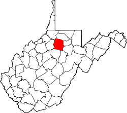
Geography
Downtown Clarksburg as viewed from the east on Main Street
Clarksburg had a humid continental climate if one considers the 0°C isotherm. The latest temperature numbers have the climate as humid subtropical (Cfa). To the molds of Köppen the climate may be considered the southern boundary of the Dfb zone at low altitudes in the North American continent (limit of 39 ° N), although in the immediate vicinity it is Dfa.[23] The city still suffers strong influences from the south, especially from the Gulf of Mexico but due to its location has a much more significant influence of the cold air intrusion of Canada, where it is not protected by the Appalachians. The extent further to the south is due to the eastern and southeastern mountain ranges blocking the oceanic influence in part, even if it is minimal anyway by the considerable distance from the coast. At the same time it can be classified as Cfa or hybrid of different climatic zones according to the criterion to be surveyed,[24] a situation similar to that of Boston.[23] It is the Dfb boundary throughout the northern hemisphere if it is to be disregarded in elevated regions on all continents. The southern record could appear on the Korean peninsula but the dry season defined version (Dwb) predominates in these locations.[25] The average temperature is 52.2°F (11.2°C) with a high average of 63.3°F (17.4°C) and a low average of 41.1°F (5.1°C). It has 45.6 inches (1,160mm) of rain with peak in May (4.8 inches or 122mm) and lower value in February with 3.2 inches (81mm). The amount of total snow is 25 inches (64cm), with highest values between January and February, 8 inches (20cm) in total for each month. Since the season of snowfall goes from November to March.[26]
Record temperatures range from −24°F (−31°C) on January 19, 1994, up to 102°F (39°C) as recently as September 3 and 4, 1953.[27]
There were 6,588 households, of which 37.4% were married couples living together, 35.2% had a female householder with no spouse present, 20.4% had a male householder with no spouse present. The average household and family size was 3.3. The median age in the city was 39.7 years.[32]
2010 census
As of the census[2] of 2010, there were 16,578 people, 7,213 households, and 4,179 families residing in the city. The population density was 1,702.1 inhabitants per square mile (657.2/km2). There were 8,132 housing units at an average density of 834.9 per square mile (322.4/km2). The racial makeup of the city was 92.9% White, 3.9% African American, 0.2% Native American, 0.3% Asian, 0.3% from other races, and 2.4% from two or more races. Hispanic or Latino people of any race were 1.6% of the population.
There were 7,213 households, of which 28.5% had children under the age of 18 living with them, 38.0% were married couples living together, 14.7% had a female householder with no husband present, 5.2% had a male householder with no wife present, and 42.1% were non-families. 35.3% of all households were made up of individuals, and 14.6% had someone living alone who was 65 years of age or older. The average household size was 2.25 and the average family size was 2.91.
The median age in the city was 39.5 years. 21.9% of residents were under the age of 18; 7.9% were between the ages of 18 and 24; 26.8% were from 25 to 44; 27.1% were from 45 to 64; and 16.3% were 65 years of age or older. The gender makeup of the city was 48.0% male and 52.0% female.
2000 census
As of the census of 2000, there were 16,743 people, 7,447 households, and 4,378 families residing in the city. The population density was 1,758.3 inhabitants per square mile (678.9/km2). There were 8,662 housing units at an average density of 909.7 per square mile (351.2/km2). The racial makeup of the city was 93.86% White, 3.83% African American, 0.13% Native American, 0.36% Asian, 0.05% Pacific Islander, 0.44% from other races, and 1.34% from two or more races. Hispanic or Latino people were 1.06% of the population.
There were 7,447 households, out of which 25.0% had children under the age of 18 living with them, 41.6% were married couples living together, 13.4% had a female householder with no husband present, and 41.2% were non-families. 36.7% of all households were made up of individuals, and 17.3% had someone living alone who was 65 years of age or older. The average household size was 2.20 and the average family size was 2.87.
In the city, the population was spread out, with 21.1% under the age of 18, 8.3% from 18 to 24, 27.3% from 25 to 44, 22.7% from 45 to 64, and 20.7% who were 65 years of age or older. The median age was 40 years. For every 100 females, there were 86.2 males. For every 100 females age 18 and over, there were 81.6 males.
The median income for a household in the city was $27,722, and the median income for a family was $35,075. Males had a median income of $30,194 versus $22,388 for females. The per capita income for the city was $17,587. About 14.8% of families and 19.8% of the population were below the poverty line, including 28.5% of those under age 18 and 11.9% of those age 65 or over.
Economy
Postcard of Main Street in Clarksburg, looking east (1904)
Clarksburg’s economy historically centered on manufacturing, glass production, and transportation. The city’s location along major rail lines and its proximity to natural gas and raw materials attracted industries such as chemical plants, brickworks, potteries, foundries, machine shops, hardwood and casket companies, and several major glass factories. Among these were the Akro-Agate marble company, the Hazel-Atlas Glass Company, the Rolland Glass Company, and the Jackson (later Phillips) Sheet and Tin Plate Company, an early forerunner of Weirton Steel. Economic growth brought successive waves of immigrants in the 19th and early 20th centuries, including Irish, Italians, Greeks, French, Belgians, and Spanish.[9]
During the early 20th century Clarksburg became one of the nation’s foremost glass-making centers. Akro Agate relocated from Akron, Ohio, in 1914 and became famous for colorful marbles and pressed-glass housewares, producing more than two million marbles per week at its peak. Hazel-Atlas Glass Company operated the world’s largest tumbler factory in Clarksburg, employing more than 1,000 people by 1920. The Rolland Glass Company, founded in 1921 by Albert Rolland, produced fine tableware and stemware until its closure in 1985. Other firms included the Clarksburg Glass Company, National Bottle Company, Diamond Glass Company, and West Virginia Glass Specialty Company. Collectors continue to prize Clarksburg glass products for their craftsmanship and color.[33][34][35]
By 1929 Clarksburg reached its peak population of more than 35,000 residents. The Great Depression and mid-century industrial decline reduced employment, but the city remained an important transportation and distribution hub during World War II. Construction of Interstate 79 and the four-lane U.S. Route 50 in the 1970s reconnected Clarksburg to major markets and encouraged suburban retail growth, particularly at the Eastpointe and Newpointe shopping centers along the interstate.
Clarksburg-Harrison Public Library
Federal and technology employment expanded in the 1990s, highlighted by the opening of the FBI’s Criminal Justice Information Services Division (CJIS) complex in 1995. The $200-million facility, located on 986 acres (399ha), serves as the national repository for the FBI’s criminal justice records and remains one of the largest employers in north-central West Virginia.[36]
In 1975 Clarksburg opened a new public library designed by architect Marcel Breuer, adding another distinctive element to its architecturally rich downtown.[37] The city today relies primarily on government, health care, education, and professional services. Downtown now hosts law offices, financial institutions, and cultural venues, while retail activity has largely relocated to the interstate corridor. Clarksburg also supports a daily newspaper, the Exponent-Telegram, several local television stations, and six radio outlets.[38]
Clarksburg serves as a cultural center for north-central West Virginia, noted for its historic architecture, festivals, and performing-arts venues.[39]
Faith-based and arts programming have expanded in recent years. The downtown Jesus Fest WV features Christian music and community outreach each August,[41] while the Robinson Grand Performing Arts Center—originally opened in 1913 and restored in 2018—hosts touring performances and local productions, including the Born & Bred Concert Series highlighting West Virginia musicians.[42] Since 2023 the city has also been home to the MTN Craft Film Festival, which showcases Appalachian-themed and independent films.[43]
Recreational traditions are another part of the city’s identity. The Greater Clarksburg 10K, established in 1997 and renamed in 2007 in memory of journalist J. Cecil Jarvis, serves as the official West Virginia 10K State Championship.[45]
Several notable individuals in American politics, science, and the arts were born in or have strong ties to Clarksburg. The city was the birthplace of Thomas J. "Stonewall" Jackson, Confederate general during the American Civil War, and John W. Davis, the 1924 Democratic presidential nominee and U.S. ambassador to the United Kingdom.[49]
Author Melville Davisson Post, a pioneer of the American detective story and creator of the Uncle Abner series, was also born in Clarksburg.[50]
Cyrus Vance, born in Clarksburg in 1917, served as U.S. Secretary of State under President Jimmy Carter.[51]
NASA mathematician Katherine Johnson, whose story was dramatized in the film Hidden Figures, attended the former Kelly Miller High School in Clarksburg before graduating from West Virginia State University.[52]
↑"Station: Clarksburg Benedum AP, WV". U.S. Climate Normals 2020: U.S. Monthly Climate Normals (1991–2020). National Oceanic and Atmospheric Administration. Archived from the original on June 24, 2021. Retrieved June 13, 2021.
↑"Station: Clarksburg 1, WV". U.S. Climate Normals 2020: U.S. Monthly Climate Normals (1991–2020). National Oceanic and Atmospheric Administration. Archived from the original on June 13, 2021. Retrieved June 13, 2021.
This page is based on this Wikipedia article Text is available under the CC BY-SA 4.0 license; additional terms may apply. Images, videos and audio are available under their respective licenses.


