The Potomac River is located within the Mid-Atlantic region of the United States and flows from the Potomac Highlands into the Chesapeake Bay. The river is approximately 405 miles (652 km) long, with a drainage area of about 14,700 square miles (38,000 km2). In terms of area, this makes the Potomac River the fourth largest river along the Atlantic coast of the United States and the 21st largest in the United States. Over 5 million people live within the Potomac watershed.

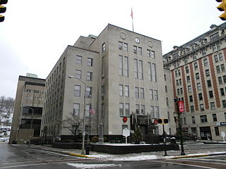
Clarksburg is a city in and the county seat of Harrison County, West Virginia, United States, in the north-central region of the state. The population of the city was 16,578 at the 2010 census. It is the principal city of the Clarksburg, WV Micropolitan Statistical Area, which had a population of 94,221 in 2014. Clarksburg was named National Small City of the Year in 2011 by the National League of Cities.

Tornado is a census-designated place (CDP) in Kanawha County, West Virginia, United States. Tornado is also known as Upper Falls, the U.S. Census Bureau's official name for the community. The United States Board on Geographic Names declared the community's official name to be Tornado in 2013 due to a request from the Kanawha County Commission, which determined that residents of the community supported the name Tornado over Upper Falls. It is also known as Andrews Heights, Big Bend and Upper Falls of Coal River.

The Midland Trail is a National Scenic Byway which carries U.S. Route 60 (US 60) through a portion of the southern part of the U.S. state of West Virginia between Charleston and Sam Black Church. It was part of the longer transcontinental Midland Trail.

The New River Gorge National River is a unit of the United States National Park Service designed to protect and maintain the New River Gorge in southern West Virginia. Established in 1978, the NPS-protected area stretches for 53 miles (85 km) from just downstream of Hinton to Hawks Nest State Park near Ansted.

The Elk River is a tributary of the Kanawha River, 172 miles (277 km) long, in central West Virginia in the United States. Via the Kanawha and Ohio rivers, it is part of the watershed of the Mississippi River.

The Coal River is a tributary of the Kanawha River in southern West Virginia. It is formed near the community of Alum Creek by the confluence of the Big and Little Coal Rivers, and flows generally northward through western Kanawha County, past the community of Upper Falls and into the Kanawha River at St. Albans.

The West Fork River is a principal tributary of the Monongahela River, 103 miles (166 km) long, in north-central West Virginia in the United States. Via the Monongahela and Ohio Rivers, it is part of the watershed of the Mississippi River, draining an area of 881 square miles (2,284 km²) on the unglaciated portion of the Allegheny Plateau.

The Blackwater River is a 34.3-mile-long (55.2 km) river in the Allegheny Mountains of eastern West Virginia, USA. Via the Black Fork, it is a principal tributary of the Cheat River. Via the Cheat, the Monongahela and the Ohio rivers, it is part of the watershed of the Mississippi River and drains an area of 142 square miles (370 km2). It is a true blackwater stream, owing to spruce and hemlock trees in its watershed, the tannins of which impart a tea or amber color to its water.

Arlington is an unincorporated community along the West Fork River in Harrison County, West Virginia, United States. It is located directly north of the city of Clarksburg.
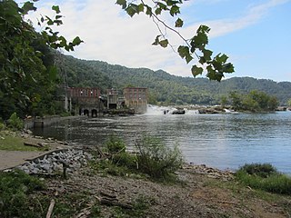
Glen Ferris is a census-designated place (CDP) on the western bank of the Kanawha River in Fayette County, West Virginia. It is situated approximately one mile south of the town of Gauley Bridge. The sole highway linking Glen Ferris to the area is U.S. Route 60, known also as the Midland Trail. As of the 2010 census, its population was 203; the community had 104 housing units, 87 of which were occupied. The village is roughly a mile and a half in length. Glen Ferris is home to two churches, one Apostolic and one Methodist. A railway owned by Norfolk Southern runs parallel to US Route 60 through the village.

Elk Creek is a tributary of the West Fork River, 29 miles (47 km) long, in north-central West Virginia, USA. Via the West Fork, Monongahela and Ohio Rivers, it is part of the watershed of the Mississippi River, draining an area of 121 square miles (310 km2) on the unglaciated portion of the Allegheny Plateau. The stream is believed to have been named by an 18th-century trapper and hunter named John Simpson, who encountered herds of elk along the stream.

Simpson Creek is a tributary of the West Fork River, 28 miles (45 km) long, in north-central West Virginia, USA. The stream was named for hunter and trapper John Simpson, who left his name on it after building and living in a cabin there for several months in 1763 and '64.
Ashford is an unincorporated community and once active coal town in Boone County, West Virginia, United States. It was established by the Crawford and Ashby land company. A former mining town, Ashford includes all of the communities in the 25009 zip code from the top of Lens Creek Mountain to the bridge crossing Big Coal River, thence up the river (south) toward Costa and down the river (north) to Emmons and Lower White Oak. Rumble was a separate coal camp located within the area known as Ashford, but never had its own post office although there was an elementary school there that burned circa 1960. What was known as Rumble starts near Casey Fork Hollow and continues along County Route 1 to just past the new Ashford-Rumble School. From the Ashford bridge you can travel to Lower White Oak and Emmons and to Dartmont. Ashford Hill Road follows the east side of Big Coal River and is also considered part of Ashford. Ashford Hill Road ends at Brier Branch. Ashford no longer has a post office. The Ashford post office was destroyed by fire in 2005, and was never reopened. In August 2008, the brand new Ashford bridge opened to the public. The new bridge was named as a memorial to Willis W. Elkins a WWII Navy submarine crewman and long-time educator who was born about 100 yards from where the new bridge stands. The original bridge, constructed in 1923, was demolished on August 26, 2008.

Scott's Gulf is a canyon situated along the Caney Fork in White County, Tennessee, in the southeastern United States. The canyon stretches for approximately 18 miles (29 km) as the Caney Fork drops from the top of the Cumberland Plateau down to the eastern Highland Rim. This remote section of the river is home to a wilderness area consisting of a largely undisturbed deciduous forest, numerous waterfalls, caves and other geological formations, and Class IV and Class V whitewater rapids.
Glen Jean is a census-designated place (CDP) in Fayette County, West Virginia, United States, near Oak Hill. As of the 2010 census, its population is 210.
Cannelton is an unincorporated community in Fayette County, West Virginia, United States. Cannelton is 1 mile (1.6 km) northeast of Smithers, along Smithers Creek. Cannelton has a post office with ZIP code 25036. The community was named for the deposits of cannel coal in the area.

Virginia State Route 102 and West Virginia Route 102 are adjoining state highways in the U.S. states of Virginia and West Virginia. The two state highways together run 11.4 miles (18.3 km) from Center Street in Pocahontas, Virginia east to the Virginia – West Virginia state line between the twin cities of Bluefield, Virginia and Bluefield, West Virginia. Most of Route 102 consists of three sections in Virginia maintained by the Virginia Department of Transportation (VDOT); the two intervening sections in West Virginia are maintained by the West Virginia Division of Highways. In addition to connecting Pocahontas with the two Bluefields, the state highway passes through Nemours, West Virginia and Falls Mills, Virginia and provides access to Bluefield College.