Enterprise, West Virginia

Last updated
Enterprise, West Virginia
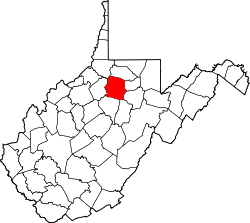
WVMap-doton-Enterprise.PNG
Location of Enterprise, West Virginia
Coordinates: 39°25′11″N80°16′36″W / 39.41972°N 80.27667°W / 39.41972; -80.27667
Country United States
State West Virginia
County Harrison
Area
  Total2.9 sq mi (7.6 km2)
  Land2.9 sq mi (7.6 km2)
  Water0.0 sq mi (0.0 km2)
Elevation
951 ft (290 m)
Population
 (2010) [1]
  Total961
  Density330/sq mi (130/km2)
Time zone UTC-5 (Eastern (EST))
  Summer (DST) UTC-4 (EDT)
ZIP code
26568
Area code 304
FIPS code 54-25516 [2]
GNIS feature ID1554406 [3]

Enterprise is a census-designated place (CDP) in Harrison County, West Virginia, United States, along the West Fork River. The population was 961 at the 2010 census. [1]

Contents

Geography

Enterprise is located at 39°25′11″N80°16′36″W / 39.41972°N 80.27667°W / 39.41972; -80.27667 (39.419860, -80.276738). [4]

According to the United States Census Bureau, the CDP has a total area of 2.9 square miles (7.5 km2), all land.

Demographics

As of the census [2] of 2000, there were 939 people, 378 households, and 275 families residing in the CDP. The population density was 319.8 people per square mile (123.5 people/km2). There were 413 housing units at an average density of 140.7 per square mile (54.3/km2). The racial makeup of the CDP was 99.89% White, and 0.11% from two or more races. Hispanic or Latino of any race were 0.64% of the population.

There were 378 households, out of which 27.2% had children under the age of 18 living with them, 61.1% were married couples living together, 10.1% had a female householder with no husband present, and 27.0% were non-families. 24.6% of all households were made up of individuals, and 13.8% had someone living alone who was 65 years of age or older. The average household size was 2.48 and the average family size was 2.94.

In the CDP, the population was spread out, with 21.7% under the age of 18, 7.7% from 18 to 24, 27.5% from 25 to 44, 26.1% from 45 to 64, and 17.0% who were 65 years of age or older. The median age was 41 years. For every 100 females, there were 93.2 males. For every 100 females age 18 and over, there were 92.4 males.

The median income for a household in the CDP was $29,583, and the median income for a family was $35,417. Males had a median income of $27,798 versus $20,341 for females. The per capita income for the CDP was $13,541. About 13.1% of families and 20.2% of the population were below the poverty line, including 30.3% of those under age 18 and 19.0% of those age 65 or over.

Related Research Articles

<span class="mw-page-title-main">Underwood-Petersville, Alabama</span> Census-designated place in Alabama, United States

Underwood-Petersville is a census-designated place (CDP) in Lauderdale County, Alabama United States. It is part of the Florence - Muscle Shoals Metropolitan Statistical Area known as "The Shoals". As of the 2010 census, the population of the CDP is 3,247.

<span class="mw-page-title-main">Long Hill, Groton, Connecticut</span> Census-designated place in Connecticut, United States

Long Hill is a census-designated place (CDP) in the town of Groton in New London County, Connecticut, United States. The population was 4,205 at the 2010 census.

Moss Bluff is a census-designated place (CDP) in Calcasieu Parish, Louisiana, United States. The population was 12,522 at the 2020 census. Located just north of the city of Lake Charles, it is considered a suburb of that city. Moss Bluff is a burgeoning community, and is one of the communities in Calcasieu Parish besides Lake Charles and Sulphur experiencing growth. Several efforts have been made to incorporate Moss Bluff, but at the present time the community is unincorporated.

<span class="mw-page-title-main">Clover Hill, Maryland</span> Unincorporated community in Maryland

Clover Hill is an unincorporated community and former census-designated place (CDP) in Frederick County, Maryland, United States. The population was 3,260 at the 2000 census. The area was not listed as a CDP for the 2010 census, and no population total was published.

<span class="mw-page-title-main">Dry Run, Ohio</span> Census-designated place in Ohio, United States

Dry Run is a census-designated place (CDP) in Hamilton County, Ohio, United States. The population was 7,672 at the 2020 census.

<span class="mw-page-title-main">Woodbourne-Hyde Park, Ohio</span> Unincorporated community & former census-designated place in Ohio, United States

Woodbourne-Hyde Park is an unincorporated area in Washington Township in Montgomery County, Ohio, United States. A Suburb of Dayton. It was delineated as a census-designated place (CDP) at the 2000 census, at which time its population was 7,910. It was not delineated as a CDP for the 2010 census.

<span class="mw-page-title-main">North Fork Village, Ohio</span> Former CDP in Ohio, United States

North Fork Village is an unincorporated community and former census-designated place (CDP) in Ross County, Ohio, United States. The population was 1,726 at the 2000 census. It was not delineated as a CDP for the 2010 census.

<span class="mw-page-title-main">Sciotodale, Ohio</span> Census-designated place in Ohio, United States

Sciotodale is a census-designated place (CDP) in Scioto County, Ohio, United States. The population was 1,081 at the 2010 census.

<span class="mw-page-title-main">Bolindale, Ohio</span> Census-designated place in Ohio, United States

Bolindale is an unincorporated community and census-designated place in southern Howland Township, Trumbull County, Ohio, United States. The population was 1,921 at the 2020 census. It is part of the Youngstown–Warren metropolitan area.

<span class="mw-page-title-main">Adamsville, Pennsylvania</span> Census-designated place in Pennsylvania, United States

Adamsville is a census-designated place (CDP) in Crawford County, Pennsylvania, United States. The population was 67 at the 2010 census, down from 117 in 2000.

<span class="mw-page-title-main">Fairdale, Pennsylvania</span> Census-designated place in Pennsylvania, United States

Fairdale is a community and census-designated place (CDP) in Greene County, Pennsylvania, United States. The population was 2,059 at the 2010 census.

<span class="mw-page-title-main">Morrisville, Greene County, Pennsylvania</span> Census-designated place in Pennsylvania, United States

Morrisville is a census-designated place (CDP) in Franklin Township, Greene County, Pennsylvania, United States. The population was 1,265 at the 2010 census.

<span class="mw-page-title-main">McGovern, Pennsylvania</span> Census-designated place in Pennsylvania, United States

McGovern is a census-designated place (CDP) in Washington County, Pennsylvania, United States. The population was 2,742 at the 2010 census.

<span class="mw-page-title-main">Weigelstown, Pennsylvania</span> CDP in Pennsylvania, United States

Weigelstown is a census-designated place (CDP) in York County, Pennsylvania, United States. The population was 12,875 at the 2010 census.

Shiloh is a census-designated place (CDP) in Sumter County, South Carolina, United States. The population was 259 at the 2000 census. It is included in the Sumter, South Carolina Metropolitan Statistical Area.

<span class="mw-page-title-main">Lakeside, Virginia</span> Census-designated area in Virginia

Lakeside is a census-designated place (CDP) in Henrico County, Virginia, United States. It is an inner suburb of Richmond, Virginia. The population was 11,849 at the 2010 census.

<span class="mw-page-title-main">Wiley Ford, West Virginia</span> CDP in West Virginia, United States

Wiley Ford is a census-designated place (CDP) in Mineral County, West Virginia, United States and part of the 'Cumberland, MD-WV Metropolitan Statistical Area'. The population was 1,026 at the 2010 census.

<span class="mw-page-title-main">Littleton, West Virginia</span> Census-designated place in West Virginia, United States

Littleton is a census-designated place (CDP) in Wetzel County, West Virginia, United States. The population was 198 at the 2010 census.

<span class="mw-page-title-main">Ipswich (CDP), Massachusetts</span> Census-designated place in Massachusetts, United States

Ipswich is a census-designated place (CDP) located in the town of Ipswich in Essex County, Massachusetts, United States. The population was 4,222 at the 2010 census.

<span class="mw-page-title-main">Brookhaven (CDP), New York</span> Hamlet and census-designated place in New York, United States

Brookhaven is a hamlet and census-designated place in Suffolk County, New York, United States. The population was 3,451 at the 2010 census.

References

  1. 1 2 "U.S. Census website". United States Census Bureau . Retrieved 2011-05-14.
  2. 1 2 "U.S. Census website". United States Census Bureau . Retrieved 2008-01-31.
  3. "US Board on Geographic Names". United States Geological Survey. 2007-10-25. Retrieved 2008-01-31.
  4. "US Gazetteer files: 2010, 2000, and 1990". United States Census Bureau. 2011-02-12. Retrieved 2011-04-23.